Climate change, drought, and anthropogenic effects are among the main drivers causing alterations in natural resources one of which is the lake level (LL) of large saline lakes, which are mainly located in arid and semi-arid regions. As an urgent need to manage natural resources, this study focuses on determining the significant reasons for the shrinkage problem of saltwater lakes. To this end, the long-term severity and frequency of droughts from 2003 to 2020 and their spatiotemporal distribution in the Lake Urmia Basin (the second largest saline lake on Earth) were investigated based on the normalized difference vegetation index (NDVI) anomaly. Thereafter, monthly soil moisture, evapotranspiration, land surface temperature (LST), LL, NDVI, and precipitation time series were collected, Boolean images were used to generate drought frequency maps, and Mann-Kendall trend test techniques and wavelet transform coherence (WTC) were used to determine the impacts of anthropogenic activities and climate change on the region. The results indicated that the basin had only non-drought and mild drought conditions and did not experience moderate, severe, or very severe droughts. The results indicated that the mild drought indices covered 80% of the total area and were exposed for more than seven years. Pearson correlation analysis indicated that the primary reason for the drought was temperature anomalies (r = −0.68) in the basin. The annually changing drought conditions in the basin revealed human effects on the basin. The results indicated a statistically significant positive trend in evapotranspiration time series, which was a reason for the LL decline. Thereafter, wavelet coherence was employed to delve deeper into the correlation between LL and the hydro-environmental datasets. The increasing vegetation cover in the situation that precipitation, land surface temperature, and soil moisture had stable conditions as well as common periodicities between the hydro-environmental variables, and the abrupt change points in significant periodicities revealed that anthropogenic activities in terms of agricultural expansion had increased in the basin. Besides, the annually changing condition of drought in the basin is also an indicator of anthropogenic activities that affect the environment. The differences in the spatial distribution of the NDVI maps also indicated that people living in the western, eastern, and southern regions of the basin had cultivated more land.
Related content
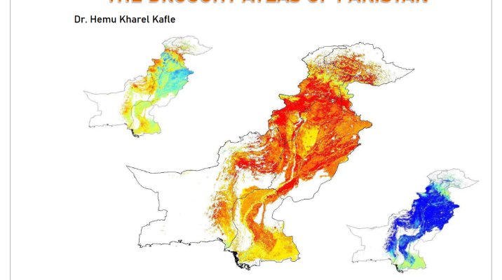
The Drought Atlas of Pakistan
Project Final Report: ARCP2001-06
