Overview
Several Ocean Remote Sensing training courses were delivered in 2021 and 2022, aiming to build the capacity of early-career scientists (ECS) towards sustainability and climate resilience through effective ocean monitoring by satellite remote sensing. There were two versions of the workshops: 1) Virtual training on the successfully developed Massive Open Online Course (MOOC) platform; and 2) Physical training at the Universiti Teknologi Malaysia (UTM) in Johor Bahru, Malaysia. The virtual training course was conducted during the COVID-19 Pandemic pause in 2021 and 2022 and comprised 13 pre-recorded modules and a student-mentorship programme. It won a silver award during the International University Carnival on E-Learning (IUCEL) 2021. The physical training course strengthened the ECS knowledge, practical exercises and social interactions among peers and instructors during four days of training and two days of the conference. The level of achievement (>70%) of programme learning outcomes and the overall score (4.5/5.0) of the training indicates a good standard of planning, delivery and evaluation. These workshops were merely the first steps in a necessarily long and persistent effort to establish a network of ocean remote sensing experts comprising both senior and ECS throughout Asia that will apply remote-sensing technology towards climate resilience in the region.
Key Messages
- Remote sensing workshops strengthened the capacity of Asian-wide early-career scientists (ECS).
- Remote-sensing technology is vital for ocean climate resilience.
- Mentorship programmes enhance the network among ECS and senior scientists.
- Both virtual and in-person training components can complement each other to contribute to a comprehensive and well-rounded educational experience.
Multimedia generated
Introduction
Oceans and coastal regions are integral components of Earth’s ecology and climate, holding vital importance for both society and biology. Coastal cities in Asia, such as Malaysia, Indonesia, and Thailand, face climate change vulnerabilities due to natural and anthropogenic factors like resource extraction and shifting weather patterns. Indonesia, Thailand, and the Philippines are particularly at risk of land subsidence due to soil consolidation and excessive groundwater extraction, accentuating the need for awareness (Parker, 2020; Raucoules et al., 2013).
To enhance maritime climate preparedness, technology enabling consistent monitoring of oceans, marginal seas, and coastal zones is imperative. Remote sensing from space offers unparalleled accessibility and coverage, coupled with in situ measurements, crucial for tracking marine resources, assessing climate and human impacts, and studying climate variability, biodiversity, and ecosystems (Chen et al., 2022; Idris, 2019; Lan et al., 2017; Noone, 2013; Rohana & Yusof, 2022). Effective training and exposure to scientific data from space missions are essential for scientists engaged in ocean-climate resilience. Capacity-building initiatives facilitate excellence in developing countries, promote data utilization, and offer practical exercises using analysis tools (Katsaros et al., 2017), fostering international collaboration and minimizing isolation.
The Pan Ocean Remote Sensing (PORSEC) Association, active since 1992, fosters global coordination and capacity-building efforts among developed and developing nations. Bi-annual activities in the Asia-Pacific and beyond support marine sciences via remote-sensing technology, enriching understanding of environmental processes (Levy et al., 2018; Levy et al., 2016). However, the COVID-19 pandemic has disrupted research networks and prompted a shift to exclusive virtual learning for knowledge dissemination (Coman et al., 2020; Yusof et al., 2022). In preserving oceans and coastal regions for future generations, sustained research, training, and collaborative efforts remain pivotal.
Ocean remote-sensing training course
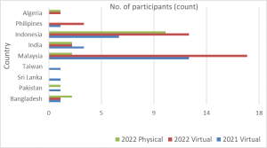
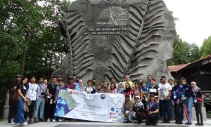
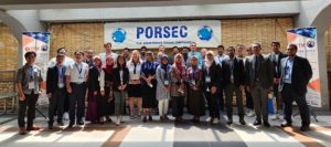
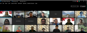
The training course “Ocean Remote Sensing towards Climate Resilience” focused on enhancing early-career scientists’ (ECS) capabilities and fostering mentor-mentee relationships. The course, available virtually and physically, aimed to develop ECS skills in ocean remote sensing, scientific idea formulation, research projects, and academic paper writing. It facilitated connections between senior scientists and ECS to refine scientific concepts and projects. The virtual training took place during the pandemic through an Open Learning platform, while the physical course was conducted at UTM, Malaysia, in December 2022, engaging participants from Pan Asia. The curriculum covered science, application, student-mentorship projects, presentations, and social aspects, fostering comprehensive learning. Student projects spanned climate-ocean, habitat modeling, sea-level rise, and shoreline changes. Social interactions were promoted, with group activities, discussions, and presentations, more enriched in the physical mode with field trips and shared accommodations. The virtual course innovatively emphasised mentor-mentee engagement, facilitating private communication and tailored assignments to cater to participants’ practical needs and job demands.
| No. | Modules | Trainers | Affiliation |
|---|---|---|---|
| 1 | Fundamentals of remote sensing | Kasturi Devi Kanniah | Universiti Teknologi Malaysia, Malaysia |
| 2 | Fundments of sea surface temperature and thermal front analysis | Ming An Lee | National Taiwan Ocean University, Taiwan |
| Yi Chang | National Sun Yat-Sen University, Taiwan | ||
| 3 | Fundamentals of radar altimetry | Nurul Hazrina Idris | Universiti Teknologi Malaysia, Malaysia |
| Stefano Vignudelli | The National Research Council (CNR), Italy | ||
| 4 | Fundamentals of ocean colour | Cara Wilson | The National Oceanic and Atmospheric Administration (NOAA), United States of America |
| 5 | Fundamentals of microwave radiometric and unmanned aerial vehicle mapping | Leonid Mitnik | Russia Academy of Science, Russia |
| Norhadija Darwin | Universiti Teknologi Malaysia, Malaysia | ||
| 6 | Satellite wind data and applications | Abderrahim Bentamy | French Research Institute for Exploitation of the Sea (IFREMER), France |
| 7 | Data assimilation | Gad Levy | NorthWest Research Associates, United States of America |
| 8 | Machine learning | Andrew Geiss | Pacific Northwest National Laboratory, United States of America |
| 9 | Satellite applications in fisheries | Nimit Kumar | Indian National Center for Ocean Information Services (INCOIS), India |
| 10 | Nearshore altimetry | Nurul Hazrina Idris | Univeriti Teknologi Malaysia, Malaysia |
| Stefno Vignudelli | The National Research Council (CNR), Italy | ||
| 11 | Accessing satellite data with ERDDAP | Cara Wilson | The National Oceanic and Atmospheric Administration (NOAA), United States of America |
| 12 | Accessing satellite data with ArcGIS | Norhakim Yusof | Universiti Teknologi Malaysia, Malaysia |
| Norhadija Darwin | Universiti Teknologi Malaysia, Malaysia | ||
| 13 | Getting published in an international journal | Kevin J. Tansey | University of Leicester, United Kingdom Editor-in-Chief of International Journal of Remote Sensing |
Table 1: The science and applications training modules were delivered by experienced trainers.
Key findings
This section reports the key findings based on the achievement of the virtual and physical training courses. The highlights of the student projects are also reported.
Virtual training
The training outlined three programme learning outcomes (PLOs). Table 2 summarises the PLOs, the assessments, and the participants’ achievements. The programme evaluation indicated that overall PLOs have scored above 70%. PLO 1 was assessed through quizzes and tests, while PLOs 2 and 3 were assessed based on the presentation and report. On an overall average score basis, the achievements of PLOs under the communication and networking (PLOs 2 and 3) domains ranked as highest, with a score of 73%, followed by the knowledge domain (71%).
Among the major challenges of virtual training is to keep participants motivated to complete the online course. According to Claflin et al. (2022), MOOC usually has a low course completion rate (typically between 5-10%), while many participants do not intend to complete the course. In this course, 88% of the virtual participants completed all the course content, assignments, and quizzes. The strategies designed to ensure a high completion rate were: 1) selection of high-quality candidates; and 2) regular engagement among trainees-trainers. However, one must admit that virtual training has limited social engagements. Time zone differences were another challenge. As our trainees and trainers were from different continents, gathering everyone was indeed a struggle.
| PLOs | Assessment method | Participant achievements (%) |
|---|---|---|
| 1. Students can elaborate on the fundamentals of remote sensing and in-situ measurements and their techniques for monitoring the oceans, marginal seas, and coastal seas. | Quiz and test | 71 |
| 2. Students can effectively communicate effectively both in writing and verbally by giving practical examples of remote sensing techniques for monitoring the ocean-atmosphere system, especially in research and operations. | Presentation and project report | 73 |
| 3. Students are able to develop networks among fellow students and senior scientists from around the world. | Presentation and project report | 73 |
Table 2: Programme learning outcomes, assessment methods, and participant achievements.
Physical training
After facing challenges in the virtual training, the individuals who participated in the virtual training were given preference to join the in-person training in December 2022. Over 95% of those attending the in-person training had previously been part of the virtual training sessions held in 2021 and 2022. The six-day, in-person training focused on practical exercises, projects carried out in student groups, and social interactions. Table 3 summarises the trainees feedback. The overall performance score is 4.5/5.0, with all elements scored above 4.0.
Student Projects
The focus of student project clusters was on four facets of climate resilience: 1) Climate-ocean modelling; 2) Ocean colour and habitat modelling; 3) Sea level rise; and 4) Shoreline changes. The information provided in the following sections is based on the students’ report.
| Trainee’s feedback | Score (5.0) |
|---|---|
| All the learning activities are relevant to your understanding and can be applied in real life. | 4.3 |
| The tutorial modules are adequate. | 4.4 |
| The tutorial modules are easy to understand and follow. | 3.1 |
| The tutorial is effectively organised. | 4.6 |
| Instruction for tutorial materials is clear. | 4.4 |
| The instructor presented the subject matter clearly. | 4.5 |
| The instructors presented content in an organised manner. | 4.6 |
| The course instructors were accessible to students. | 4.8 |
Table 3: Trainees feedback on the physical training.
1) Climate-ocean modelling project
The short-term precipitation analysis in the Banda Sea of Indonesia was presented using satellite-derived atmospheric data. The study was conducted to compare daily precipitation rain rates derived from the three different wavelength data retrieved from the Tropical Rainfall Measuring Mission (TRMM) during 2019. The precipitation data were extracted from the Asia-Pacific Data Research Centre focusing on the Banda Sea of Indonesia. The findings showed that the combination of both products is excellent for providing accurate values of rain precipitation. The key finding is that the precipitation rate has decreased over time.
For future studies, it is recommended to include the analysis of extreme events such as droughts and El Nino Southern Oscillation (ENSO) phases and data. It is believed that promising predictions of future precipitation and extreme events can be achieved by understanding how the satellite signals react in different weather conditions and their limitation. The regression model can also be improved with machine learning methods such as Neural Network, Support Vector Machine, and Random Forest to test their reliability.
2) Ocean colour and habitat modelling project
The sea surface temperature (SST) front patterns in the water of different case studies were presented. They were the waters of the Banda Sea, south of Pakistan and Taiwan. SST is an important oceanographic parameter in marine ecosystem research and analysis. The satellite-derived data from the National Oceanic and Atmospheric Administration (NOAA) products have been used to extract thermal fronts in the exclusive economic zone of Taiwan, Pakistan, and Indonesia. Climate change distresses marine habitat resources such as fish and other species, like tuna fish production due to changes in SST, currents and other physical ocean constraints and food, species distribution can also be affected.
Over the Banda Sea, the SST value tends to be higher (29-32°C) in winter (during northwest monsoon) than in summer (during southeast monsoon) seasons (25-29°C). The summer cooling is likely due to Ekman pumping generated by the wind. The south-easterly (north-westerly) winds during the southeast (northeast) monsoon generates Ekman upwelling (downwelling) leading to low (high) SST. Over south of Pakistan, the average temperature is around 15-25°C during winter, while 25-31°C during summer. Over the northern coast of Taiwan, the range of temperature is between 27-30°C in the summer of 2021, while the average temperature in winter is 17-23°C. Over southern Taiwan, the average summer and winter SST in 2021 ranged from 28-32°C and 20-25°C, respectively. Warm waters from the Kuroshio current flow from the southern point of Taiwan along its east coast towards the Ryukyu Archipelago.
Over those case studies, the SST front tends to be more intense in the coastal region due to coastal dynamics such as coastal upwelling, coastal instability, and mixing. The front intensity varied spatially and seasonally.
3) Sea level rise project
Global warming and sea level rise threaten coastal communities risking coastal erosion, storm surges and inundation of lowlands. Global sea level trends from 2002 to 2019 were generated using satellite re-analysis of the Level 4 grid model provided by Copernicus Marine Service (CMEMS). Data shows that sea level rise occurred in most parts of Indonesia, including in the northern part of Java Island (+3 to 4 mm/yr) and the Pekalongan coastal area (4.77 mm/yr). In addition to sea level rise, Pekalongan suffered land subsidence where the minimum height of the mean sea level is -2 m. The threat of sea level rise and vertical land motion has greatly affected the community in Pekalongan. Based on data obtained from the Ministry of Energy and Mineral Resources, the northern coast of Java Island is mostly formed from alluvial plain formation, which is known as a critical zone for the land subsidence and vertical land motions. For 100 years, the total potential sinkings in Pekalongan City is 7,340.08 ha. In a linear sea level rise and vertical land motion scenario, the lowlands could sink, disrupting agriculture and building areas so as to extremely impact human activities in Pekalongan (e.g., social and economic).
4) Shoreline changes project
The study applies data from several sources to critically analyse the morpho-dynamics and coastal risk assessment of Bangladesh’s Hatiya Island. Using Landsat 7 and Landsat 8 time series datasets and supervised classification, shorelines, erosion-accretion, and land cover changes are analysed. Spatial information has been used with the ALOS PALSAR Digital Elevation Model to forecast the island’s flood risk scenario. A weighted overlay of each component has also been used to create a coastal vulnerability index. The findings show that from 2003 to 2010, erosion predominated in the north of the island, whereas accretion occurred mainly in the east and south. Most of the island’s activity from 2010 to 2017 was erosion, which changed to accretion dynamics in 2022. In terms of a 2 m or 3 m rise in the water column in the Bay of Bengal, the flood scenario reveals that 37% and 67% of the island are susceptible to severe floods. The island’s croplands and eastern beaches are the primary areas affected by these floods. The island was divided into three primary classes according to the vulnerability index, with the eastern beaches being the most exposed. Some water pockets inside the island are also subject to moderate danger.
Overall perspective
The training courses aimed to develop the capacity of ECS in ocean remote sensing, particularly related to scientific ideas, research projects and academic papers, and to establish long-term relationships through a mentor-mentee programme. The training comprised three PLOs. The level of achievements (>70%) of the PLOs and the overall score (4.5/5.0) of the physical training indicate a good standard of planning, delivery and evaluation of the training virtual and in-person training courses.
The training programme represented a pivotal step in establishing professionals with ocean and climate resilience expertise, achieved through remote-sensing technology. These training courses effectively promoted the integration of teaching and research, as they cultivated scientific concepts, advanced research initiatives and academic paper writing through student mentorship modules. Moreover, these sessions facilitated global networking opportunities for students and experienced scientists, fostering an environment conducive to sustainable learning.
The virtual training format not only introduced a novel digital learning experience but also offered the advantage of cost and time savings, as it obviated the need for travel. However, it is important to acknowledge that virtual training did have limitations. It restricted opportunities for social interaction and confined practical exercises to the realm of open-source software. To bridge this gap, in-person training was introduced to address these areas of deficiency.
During the in-person training course, particular emphasis was placed on enhancing practical exercises, encouraging collaborative projects among students, and facilitating meaningful social interactions. In contrast, the virtual courses primarily focused on delivering lectures and theoretical content. It is important to recognise that both virtual and in-person training components complement each other effectively, contributing to a comprehensive and well-rounded educational experience.
Acknowledgement
We thank the Universiti Teknologi Malaysia (UTM) and the Pan Ocean Remote Sensing Association (PORSEC) for organising the training workshops. Also, thanks go to the Asia-Pacific Network for Global Change Research (Grant CBA2020-08SY-Idris) and co-sponsors: the Committee of Space Research (COSPAR), the Scientific Committee on Oceanic Research (SCOR), the Indian National Centre for Ocean Information Services (INCOIS), and Malaysia Convention and Exhibition Bureau (MyCEB) for providing the co-support funding for the capacity building development programme.
References
- Chen, S. Y., Hashim, M., & Idris, N. H. (2022). Coastal land-use mapping along Johore Straits using Sentinel 1-SAR data with maximizing parameterization of machine learning classification. IOP Conference Series: Earth and Environmental Science, 1064(1), 012022. doi:10.1088/1755-1315/1064/1/012022
- Claflin, S., Klekociuk, S., Campbell, J., & Taylor, B. (2022). Reasons for non-completion of a massive open online course about multiple sclerosis: A mixed methods study. Multiple Sclerosis and Related Disorders, 67, 104092. doi:https://doi.org/10.1016/j.msard.2022.104092
- Coman, C., Țîru, L. G., Meseșan-Schmitz, L., Stanciu, C., & Bularca, M. C. (2020). Online Teaching and Learning in Higher Education during the Coronavirus Pandemic: Students’ Perspective. Sustainability, 12(24), 10367. Retrieved from https://www.mdpi.com/2071-1050/12/24/10367
- Idris, N. H. (2019). Wave energy resource assessment with improved satellite altimetry data over the Malaysian coastal sea. Arabian Journal of Geosciences, 12(15), 484. doi:10.1007/s12517-019-4670-z
- Katsaros, K., Levy, G., King, S., & Wilson, C. (2017). TUTORIAL ON REMOTE SENSING FOR CAPACITY BUILDING. Paper presented at the 97th American Meteorological Society Annual Meeting, 26th Symposium on Education Volume: Session 3 Outreach and Broader Impacts, Seattle, WA, USA.
- Lan, K.-W., Shimada, T., Lee, M.-A., Su, N.-J., & Chang, Y. (2017). Using Remote-Sensing Environmental and Fishery Data to Map Potential Yellowfin Tuna Habitats in the Tropical Pacific Ocean. Remote Sensing, 9(5), 444. Retrieved from https://www.mdpi.com/2072-4292/9/5/444
- Levy, G., Vignudelli, S., & Gower, J. (2018). Enabling earth observations in support of global, coastal, ocean, and climate change research and monitoring. International Journal of Remote Sensing, 39(13), 4287-4292. doi:10.1080/01431161.2018.1464101
- Levy, G., Vigundelli, S., & Gower, J. (2016). Ocean remote sensing for sustainable resources. International Journal of Remote Sensing, 37(9), 1977-1980. doi:10.1080/01431161.2016.1175804
- Noone, K. J. (2013). Chapter 5 – Sea-Level Rise. In K. J. Noone, U. R. Sumaila, & R. J. Diaz (Eds.), Managing Ocean Environments in a Changing Climate (pp. 97-126). Boston: Elsevier.
- Parker, A. (2020). Anthropogenic Drivers of Relative Sea-Level Rise in the Mekong Delta – A Review. Quaestiones Geographicae, 39(1), 109-124. doi:10.2478/quageo-2020-0009
- Rani, M., Masroor, M., & Kumar, P. (2021). 1 – Remote sensing of Ocean and Coastal Environment – Overview. In M. Rani, K. Seenipandi, S. Rehman, P. Kumar, & H. Sajjad (Eds.), Remote Sensing of Ocean and Coastal Environments (pp. 1-15): Elsevier.
- Raucoules, D., Le Cozannet, G., Wöppelmann, G., de Michele, M., Gravelle, M., Daag, A., & Marcos, M. (2013). High nonlinear urban ground motion in Manila (Philippines) from 1993 to 2010 observed by DInSAR: Implications for sea-level measurement. Remote Sensing of Environment, 139, 386-397. doi:10.1016/j.rse.2013.08.021
- Rohana, N. A., & Yusof, N. (2022). Spatio-Temporal Wave Pattern using Multi-dimensional Clustering Method for Exploring Ocean Energy Potential. IOP Conference Series: Earth and Environmental Science, 1051(1), 012013. doi:10.1088/1755-1315/1051/1/012013
- Yusof, N., Idris, N. H., Darwin, N., Kanniah, K. D., Kumar, N., & Levy, G. (2022, 17-22 July 2022). Interactive Distance Learning for Virtual Capacity Building Development Intra-Pandemic Experiences: A Case of Mooc UTM-PORSEC. Paper presented at the IGARSS 2022 – 2022 IEEE International Geoscience and Remote Sensing Symposium.
Related content
Land-Use Change and Terrestrial Carbon Stocks: Capacity Building, Impacts Assessment, and Policy Support in Southeast Asia

IPBES external review of the second order draft of the chapters and the first order draft of the summary for policymakers of the invasive alien species
