Spatial planning-based ecosystem adaptation (SPBEA) as a method to mitigate the impact of climate change: The effectiveness of hybrid training and participatory workshops during a pandemic in Indonesia
Keywords
Ecosystem adaptation · Spatial planning · Training · Workshop
Highlights
- Spatial planning-based ecosystem adaptation (SPBEA) is a critical policy concern that all stakeholders must be aware of, from the government to the public as policy users and objects.
- This concept is important for young scientists, early-career practitioners, and the community at the village level in their efforts to form a better future of sustainable spatial planning.
- Capacity building in the form of training and workshops is one of the practical ways of implementing SPBEA.
1. Introduction
1.1 Background
Climate change has a disproportionate effect on islands and coastal countries, where storms, tidal waves, sea-level rise, abrasion, accretion, coastal floods, and shoreline retreat all occur. It is expected to have a tremendous negative effect on coastal communities, especially those that rely heavily on nearby natural resources for their livelihoods. It is likely that the impact of disruption to the coastal ecosystem is not exclusively the result of a single factor but rather the result of a number of factors combined (Sutrisno et al., 2021). Consider subsidence, for example. It can have an impact on the occurrence of flooding and coastal abrasion in a coastal area, particularly when tidal waves or other sea-related phenomena are present. Coastal populations are forced to adapt their way of life to existing developments, which is not the right solution. In this case, spatial planning is a critical component of adaptation, particularly at the local level, where coastal risks may be encountered and solutions established (Robert & Schleyer-Lindenmann, 2021). Spatial planning is commonly regarded as a public sector activity concerned with influencing the future spatial distribution of activities (Yoshida et al., 2020). Thus, spatial planning is critical for facilitating proactive, preventative adaptation of human settlements to hazards induced or exacerbated by changing climate patterns and catastrophic occurrences (Mcmillana, Birkmanna, & Tangwanichagapong, 2021).
On the other hand, local planning practices encourage climate-resilient spatial planning to be fragmented, and interventions are neither systematically implemented nor carefully reviewed (Wamsler et al., 2016). This paper encourages the operationalization of ecosystem-based adaptation by spreading the understanding of how ecosystem-based adaptation can be considered in spatial planning when confronted with the effect of climate change on the coastal zone. Spalding et al., (2014) suggest that ecosystem-based adaptation approaches provide an important framework for spatial planning. The current case conveyed a vivid impression that public understanding of Spatial Planning-Based Ecosystem Adaptation (SPBEA) information is a crucial issue for all parties.
Understanding SPBEA is also important for young and early-career scientists to increase their awareness and interest in ongoing climate change. Understanding and raising awareness of the value of disaster reduction and adaptation and the role of science and technology in solving these problems is vital. Disaster reduction and adaptation is a subject that we must explore with them as part of our dedication to ensuring coastal security for future generations. Indeed, understanding SPBEA is also necessary for coastal communities since they would be particularly influenced by spatial planning policies and attempts to prevent coastal disasters.
Training and workshops are effective methods of educating young scientists and coastal communities about the need for SPBEA. However, the COVID-19 pandemic is creating barriers for traditional classroom training and workshops. So, online training has unavoidably become the preferred solution. This circumstance brings the following issues:
-
What is the effectiveness of online training for the SPBEA method?
-
Is the proposed method appropriate?
-
Is it possible to use the same strategy in rural communities?
This study aims to assess how the SPBEA concept can be shared with the young scientists and coastal communities through training and workshops and how effective the transfer of knowledge would be.
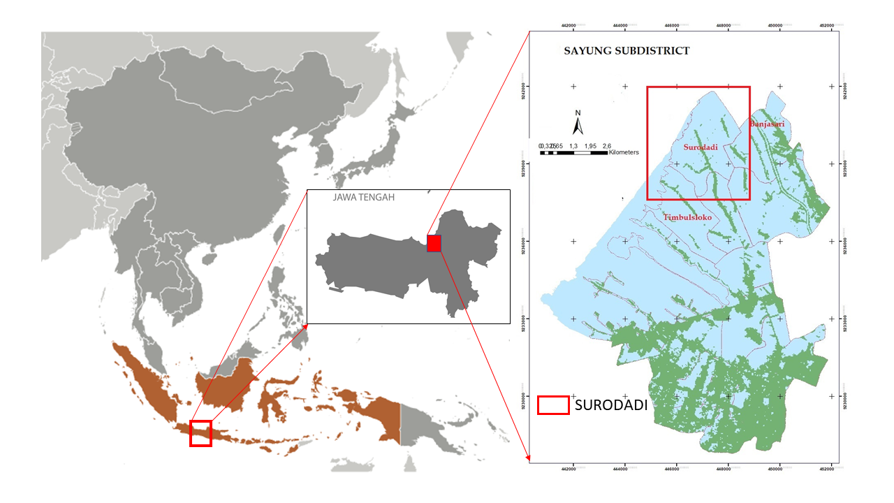
For this purpose, the subdistrict of Sayung, Demak, Indonesia, was chosen as a study area. This area is largely affected by climate change-related effects, such as tidal waves and land subsidence. Indeed, awareness of coastal ecosystem function and services, such as mangroves, has not yet been properly acknowledged (Handayani, Adrianto, Dietriech, Nurjaya, & Wardiatno, 2020).
1.2 Study area
The Sayung subdistrict is located on the north coast of central Java (see Figure 1). This coastal region is directly adjacent to the Java Sea and Semarang, the capital of Indonesia’s Central Java province. As a result, the Sayung coastal area acts as a buffer for the economic and population development of Semarang city.
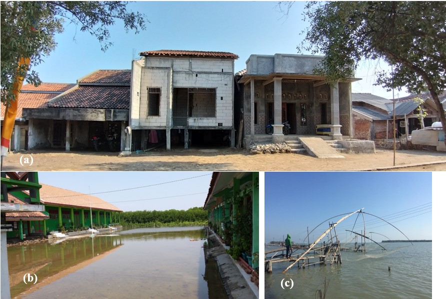
Sayung’s coastal area is lowlands with a flat surface area of less than 2% and an elevation of between 0 and 5 m above sea level (Utami, Subardjo, & Helmi, 2017). The climate was defined by an average annual rainfall of 2,292 mm and an average daily air temperature of 27.0°C (Climate-data.org, 2019). Shoreline retreat (Sriyana, Niyomukiza, Sangkawat, & Parahyangsari, 2020; Sutrisno et al., 2021), tidal floods (Haloho & Purnaweni, 2020), and relative sea-level rise are some of the factors that affect the coastal area’s long-term viability in the Sayung subdistrict (Utami et al., 2017). According to previous research, the erosion rate of coastal regions in the Sayung subdistrict ranged from 4 to 65 meters per year, with an average of 25 meters per year (Muskananfol, Supriharyono, & Febrianto, 2020). Massive conversion of mangrove forests to aquaculture ponds contributes to the degradation of coastal areas and the decline in mangrove species’ composition and physical structure (Ardhani, Murdiyarso, & Kusmana, 2020). Additionally, based on the geomorphological circumstances of Sayung’s coastal region, which has a high degree of erosion insecurity and an inundation intensity of 3.5 hours per day, these difficulties encourage people to adapt to these conditions (Sarasadi, Rudiarto, & Faradila, 2021).
In this case, local residents have adapted to environmental changes over a long period of time, whether through physical adaptation to the environment, economic adaptation through shifting livelihoods, or social adaptation through time adjustments to natural phenomena. Before the village was flooded, Sayung residents were food crop farmers. Then, they transitioned to fishpond farming or capture-fishing activities as their coastal areas shifted. Indeed, the changing coastal region has compelled the citizens of Sayung to respond physically and promptly, whether by restoring their homes or planning activities around the tidal season. Figure 2 portrays how people adapted to the changing coastal climate.
Surodadi was chosen as the workshop’s venue for detailed scale data because it has not yet fully embraced an ecosystem-based approach to village management.
2. Methods
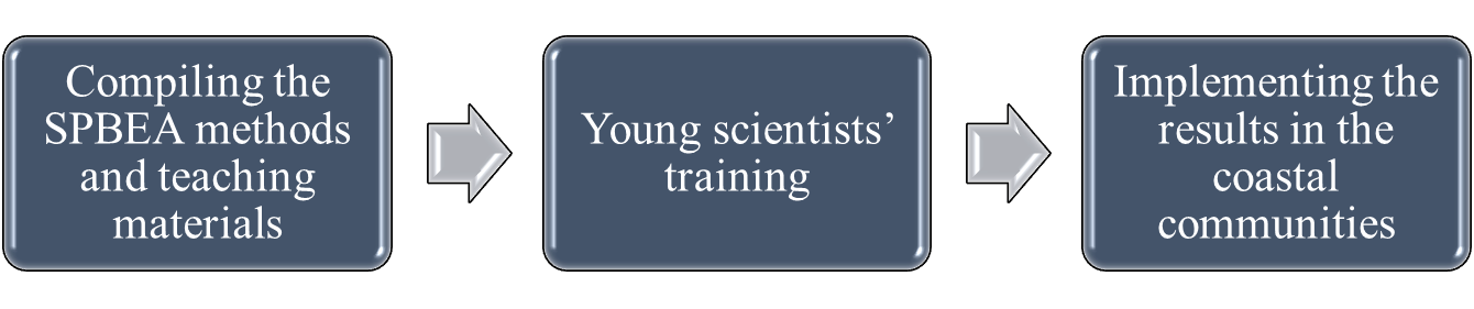
This capability building exercise employs a phased approach to disseminating SPBEA understanding to the young scientists and rural communities in the research area. The approach consisted of compiling SPBEA methods into teaching materials, then sharing the SPBEA and related sciences with young scientists to generate SPBEA zoning, and finally, disseminating the training results to coastal communities through participatory mapping techniques (see Figure 3).
As previously stated, the training technique is online owing to the COVID-19 pandemic. Limited offline training is also conducted to compare the efficacy of the training. Similarly, because online workshops are not possible due to the constraints of village community technology, the participatory SPBEA mapping workshop is conducted offline on a limited basis. The teaching materials introduced background sciences related to SPBEA, its practical implementation by geographic information system (GIS) technology, and remote sensing.
2.1 Compiling SPBEA methods and teaching materials
Teaching materials were the core of the training program. The goal is to grow participants’ awareness. Teaching materials may involve cognitive learning (knowledge) in the form of studying scientific theories and concepts, learning (skills) in the form of studying approaches to conducting and completing tasks, and effective learning (attitudes) that will manifest values or norms (Ajar, 2014). For this activity, we focused on knowledge and skills learning. The subject of the teaching materials was very specific and unique, as it pertained to SPBEA. The SPBEA material used in this training was modified from the method of Sutrisno et al., 2021 to make it easier and more feasible to implement. So, the selection of the training module and materials had to be tailored to the knowledge and skills to be acquired (Safrina, 2018), which was determined based on problem-oriented learning (see Figure 4).
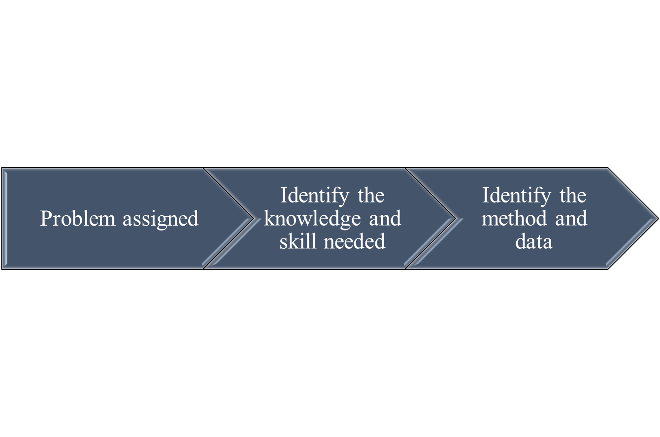
Therefore, before the implementation of the training, it is crucial to (a) determine what kind of sciences and skills must be shared in the capacity building to support the SPBEA subject, (b) determine the specific method and data, and (c) determine the scientific background of the participants. The training module was discussed with the trainers through the focus group discussion (FGD). Following that, the training materials, data, and supporting science for this training were compiled.
2.2 SPBEA training
The first thing that must be determined in implementing the training is the qualifications of participants. Due to the advanced nature of the subject, trainees must possess a background knowledge of earth sciences and the ability to comprehend and operate similar software, which the lecturers would operate during the practical session.
Due to the COVID-19 pandemic, the training was performed according to a mixed model that combines offline and online classes. The materials, data, and software used in this training were shared with the participants in advance via Google Drive, ensuring that they were prepared to use the data and software for the practicum on the first day of the training. An assessment of the effectiveness of the online training was also conducted based on observation, purposive sampling, and questionnaire analysis. Then, we evaluate the findings with the offline training. The explanation is as follows:
- The observation of the participants was employed to assess the participant’s interest in the subject being taught through the activities in questions and answers (QA) and any impediments to the training’s implementation. The number of participants who completed the training, including those who participated online, was used to evaluate interest in the training subjects.
- The purposive sampling of the most active online participants was used to evaluate whether the subjects being taught were understood, based on the participants’ ability to share training output in the forums and problems encountered in the training and technological obstacles.
- The questionnaire analysis was done during the training to determine whether participants comprehend what they are learning, the problems, suggestions, and the usefulness of the training for their future careers.
- To determine whether SPBEA training is more beneficial, we compare the outcomes of brief reports from online and offline training participants.
SPBEA zoning spatial data is expected to be generated due to the implementation of this training. This information will be built upon in greater depth during village-level spatial planning, implemented in a participatory format in a selected village.
Meanwhile, the target number of trainees was previously set at 40 for both online and offline training and the workshop participants were grouped into 10 people.
2.3 SPBEA workshop
Using the result of the training activities, a workshop with a group of pond farmers was implemented in two phases. The first stage involved an understanding exchange about SPBEA and a discussion and a brief demonstration of village spatial planning. The second stage was implemented on a small-scale village SPBEA, in which the SPBEA was implemented on a pond area adjacent to a river owned by the pond farmers’ community leader. This stage introduced the concept of a greenbelt and associated mangrove aquaculture (AMA) and polyculture as a component of SPBEA design.
AMA or silvo-fisheries and polyculture are crucial methods for adaptation in a disaster-prone village. AMA is a system of natural resource management that incorporates a mangrove greenbelt with the adjacent aquaculture. In contrast, part of the aquaculture pond is given up to make space for riverine mangroves to restore mangrove greenbelts along inland waterways and to protect adjoining fishponds (Building With Nature, 2020). Meanwhile, polyculture is a form of agriculture that replicates the diversity of natural ecosystems by simultaneously growing multiple species and in the same area (Chrispeels & Sadava, 1994). Why is a demonstration site crucial when launching an SPBEA operation in rural areas? Pond farmers are executors who undoubtedly prefer to see results rather than hypotheses or ideas on paper.
3. Result and discussion
3.1 Compiling SPBEA training materials
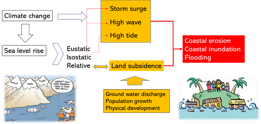
Coastal inundation, flooding and erosion are the most severe coastal disaster causes identified. Climate change issues, such as sea-level rise (eustatic, isostatic, or relative), storm surge, tidal waves, and high waves are being addressed. Considering the massive population growth and the number of industrial estates that are highly reliant on groundwater, the issue of land subsidence or relative sea-level rise is significant (see Figure 5). These issues were evaluated with the study area. It was concluded that tidal waves, land subsidence, and the degradation of the coastal landscape worsen issues related to coastal erosion and shoreline retreat. In addition to the groundwater discharge triggered by the rapid physical growth in the Sayung area, the decrease in the groundwater level and the building pressure on the specific type of soil all lead to an acceleration in the occurrence of land subsidence (Afif, Yuwono, & Awaluddin, 2018).
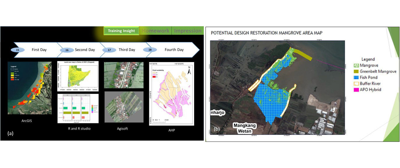
Research was conducted for evaluating the relevance of the above issues, resulting in the prototype of the SPBEA (Sutrisno et al., 2021). However, this model developed would be too complicated for the training. Thus, the SPBEA method used as training material was modified from the method of (Sutrisno et al., 2021), producing a more practical and faster process. The results of the method’s development are depicted in Figure 6 below.
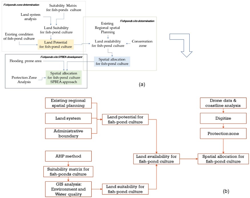
The SPBEA modelling of Sutrisno et al. (2021) is complicated and requires the development of a more complex algorithm. However, the SPBEA approach used for training is simpler and relies on fundamental GIS techniques, such as overlay, union, updates, and intersections, as well as a simple analytic hierarchy process (AHP) assessment for a pond’s aquaculture suitability area. The data for training can then be defined based on the requirement of SPBEA model development (see Table 1).
|
Data |
Type |
Data Output |
|---|---|---|
|
Land system |
Ancillary data |
|
|
The land-use/land Cover |
Ancillary data/ RS-derived map |
|
|
Base map |
Ancillary data |
• Green belts • Protection zone • Coastline |
|
Spatial plan |
Ancillary data |
|
|
Slope |
Ancillary data |
|
|
Flooding prone area |
RS derived-map |
|
|
pH |
Field data |
|
|
Salinity |
Field data |
|
|
Landsat 8 Oli |
|
• Flooding prone • Protection zone • Coastal change |
|
Drone-based map |
Field data |
• Detailed land-use map • Green belt-Protection zone • Spatial planning map |
Furthermore, the material that needs to be taught has been developed by targeting the root of the problem and why the SPBEA concept is required, particularly in the study area (see Figure 5). The teaching material is defined in Table 2.
|
Issues |
Lecture |
Objective |
|---|---|---|
|
Climate change that can trigger coastal disasters, such as sea-level rise, storm surge, and tidal waves |
The impact of climate change on coastal area disasters, based on a hydrological approach |
To explain how disasters can affect the coastal environment |
|
Assessing the impact of climate change on the coastal area to mitigate the impact |
To create a spatial model of climate change’s impact on the coastal environment |
|
|
Using the coastal vulnerability index (CVI) |
To assess the vulnerability of coastal areas to climate change |
|
|
Population growth and physical development has changed the nature of the ecosystem |
Coastal ecosystem functions and services |
Understanding the ecological role of coastal ecosystems to preserve the coastal environment’s sustainability and how coastal ecosystem services can be used to enhance the wealth of coastal communities |
|
Social sensing |
To track human behaviour and public concerns |
|
|
RS data analysis using R for disaster mitigation |
To investigate spatially how mitigation can be accomplished using RS data. The result of this is coastal protection zone data |
|
|
The inclusion of coastal ecosystems in spatial planning |
Integration of coastal and land spatial planning |
To learn about ICZM through spatial planning |
|
Sustainable coastal aquaculture: implementation of AMA, LEISA, and IMTA |
To improve understanding of how to spatially manage sustainable aquaculture |
|
|
Spatial planning-based ecosystem adaptation theory and practice |
To learn how the SPBEA method is developed |
|
|
Implementation of detailed SPBEA |
Spatial data acquisition using UAVs and their processing |
To learn how big-scale mapping can be derived for a detailed SPBEA model |
|
GCPs and photogrammetry for big-scale mapping |
||
|
Big-scale mapping |
Note: AMA = Associated mangrove aquaculture, LEISA = Low external input for sustainable aquaculture, IMTA= Integrated multi trophic aquaculture.
The preceding categorizations thoroughly describe the phases of the training material. The training begins by imparting a fundamental understanding of the disaster issues caused by climate change in coastal areas and an understanding of the ecological role of coastal ecosystems for disaster reduction. The training then focuses on spatial planning to deal with disasters based on the concept of adaptation to coastal ecosystems. These materials are taught with lecturers or instructors assigned to each subject depending on their expertise.
3.2 SPBEA training
Training is a critical component of building human capital capability. It not only encourages an individual to expand their awareness but also plays a role in determining how effective and successful an individual is in adapting their knowledge to their work. Thus, given that the training aims to improve young scientists’ scholarly knowledge and awareness about the SPBEA concept and method as one technique for mitigating the effects of climate change on coastal areas, the effectiveness of the training is dependent on three factors. The first factor is how interesting the topic is to the young scientist; the second factor is how well the material is being taught and understood by the training participants; and the third factor is whether there are any impediments to the training’s execution.
The participants’ enthusiasm for the training topic, based on our observations, can be seen in the diagram below.
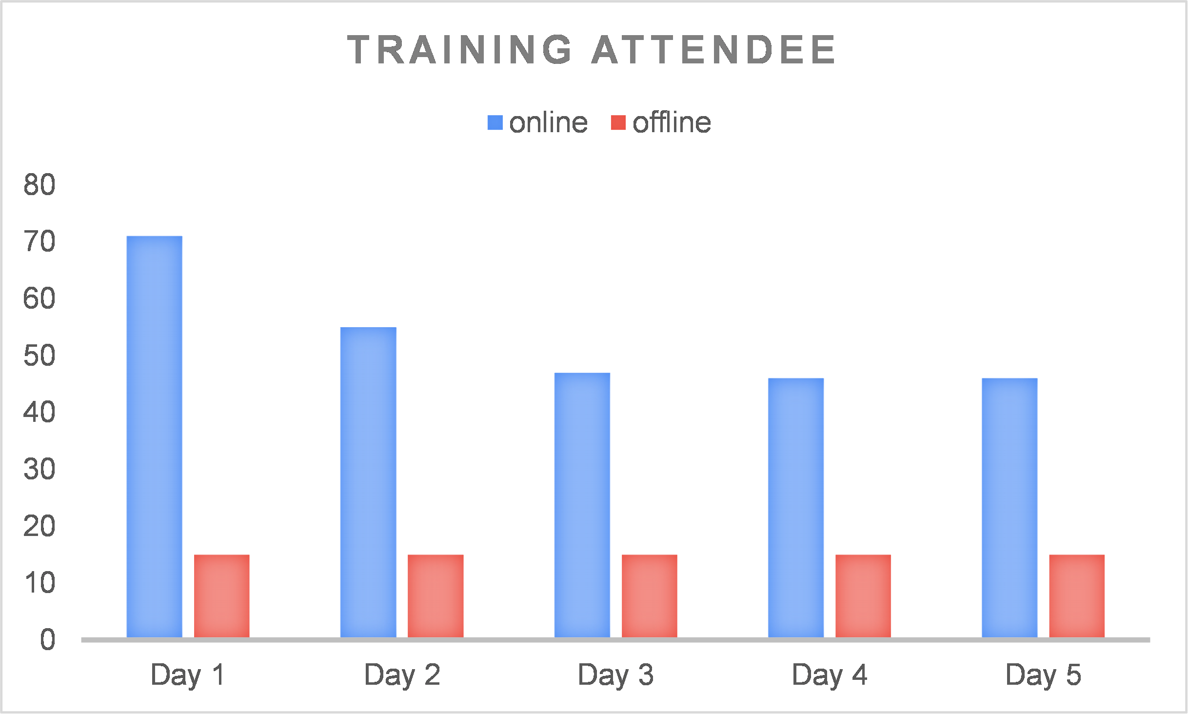
The diagram in Figure 7 shows a very high degree of enthusiasm on the first day of training for the topics and materials to be studied in the training; the number of attendees on the first day was 75, equal to the total number of participants. However, the number of participants declined on the second day among those who registered as online participants. From the third to fifth day, attendees remained relatively stable at 45 participants.
Only 60% of those who participated online successfully completed the training. However, measured in terms of the original target number of participants, which was about 40, the target was reached. The decreased number of participants could be due to technical issues such as time zone differences, network stability issues, network costs, distractions, time management issues involving the participants’ attention being diverted to other tasks that were more urgent to complete, lack of motivation, and a lack of in-person interaction. All of these factors may have discouraged the participants from completing the training. Yustika, Subagyo, and Iswati (2019) demonstrated that online classes face several challenges, including a lack of social interaction, technological limitations, and poor participant motivation. Indeed, Herbert (2006) stated that online courses have a failure retention rate of 10% to 20% higher than conventional classroom training. Even though the training target was reached, it is necessary to consider the optimal number of trainees to achieve the best outcomes. Additionally, a more rigorous selection process for the trainee is required for understanding participants’ interests. To increase the attractiveness, the training could provide incentives for participants, such as reimbursement of internet fees, incentives for those involved, and the ease of accessing information for those who have network delays, such as sharing the videos or YouTube recordings of training materials.
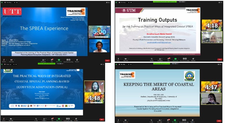
The second step in training implementation is to ascertain how well the participants retained the knowledge and skills imparted during the training, what the participants learned from the training and their experience of the training, and what overall impact the training had. To examine this question, we randomly selected 15 active participants. We used the findings to show how well they understood the training material through a presentation of the hands-on project of the training. The findings revealed that 95% of the chosen participants comprehended and enacted the material correctly. The 5% failure rate was due to a lack of ability to operate the software. Figure 8 and Figure 9 illustrate an example of the training reports and the chosen presenters.
There were no significant difficulties for the offline participants since they could complete their tasks and comprehend the content. The offline participants benefited from proximity to and direct communication with lecturers and instructors and from being more serious and focused on doing all assigned work and comprehending all training content.
From the questionnaire, 97% of participants expressed the necessity of this SPBEA concept for their jobs, while 3% could not completely comprehend it due to insufficient knowledge, technology, networks, and time. Meanwhile, 95% of participants expressed that the teaching materials were acceptable, whereas 5% desired additional in-depth knowledge and skills related to SPBEA. Most participants desired offline training due to communication issues encountered while practising the material. The following comments offer insight into what the participants experienced and what they learned from the training:
- “Many things can be learned from this training. I’ve gained new knowledge here, and I hope that events like this will be held regularly.”
- “Excellent and colourful training for me, as I learned a lot about spatial planning methods and knowledge. Thank you for considering me! I’d like to see you again. I’m looking forward to hearing from you again. Have a great time!”
- “I am very interested in this training, where I can learn new things. Hopefully, this kind of training will be continued.”
- “The most interesting topic I learn is about Big Scale Mapping because it involves data acquisition using UAV (drones) and different kinds of cameras such as Thermal Infrared Camera and Short-wave Infrared; it also involves different kind of sensors like geodetic, sonar, radar. It also involves different kinds of factors in taking photos that must be achieved, like the foreword and side overlapping, shutter speed, ISO, aperture. The drawback of this kind of mapping is the cost because it requires expensive equipment, which is not student budget-friendly. However, this topic has more to learn in the future”
- “Thank you so much for valuable training programmes.”
The training’s cumulative effect is reflected in these remarks:
- “This training course covered many informative topics that will be beneficial to my studies. I’m hoping that the video of the lectures can be shared with us.”
- “All the topics presented in the training are very interesting. I, however, find the topic of coastal integration and land spatial planning to be the most relevant to my country’s situation. SPBEA is needed for certain locations in the Solomon Islands because current adaptation projects are ineffective due to poor planning and understanding of the local geography and ecosystems. Thus, the inclusive SPBEA method could be more effective for adaptation projects.”
Participants’ feedback is very important to evaluate the success of the training, even though it is not always easy to ask the participants, especially those who participate online, to complete the questionnaire of evaluation.
3.3 SPBEA workshop
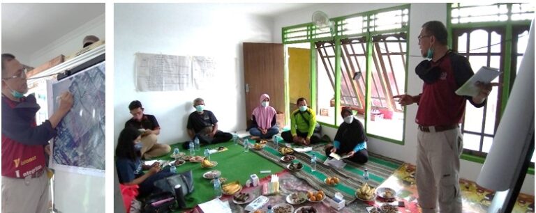
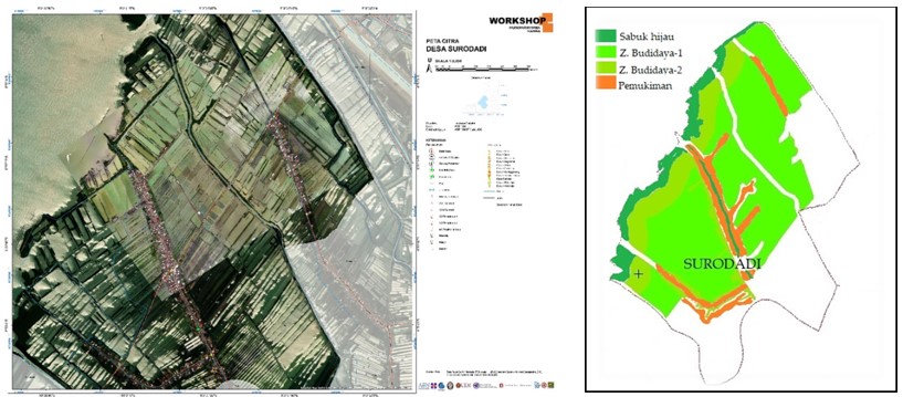
The participatory SPBEA workshop at the local level applied the SPBEA model developed during the SPBEA training. Via the training, information on coastal spatial zoning was obtained. The information fell into the categories of coastal and river protection zones, allocation zone classes for fishponds and settlements, large-scale-derived drone imagery, and the concept of AMA and polyculture (see Figure 10. These data were used at the village level for the SPBEA detail map. Surodadi, a coastal village adjacent to the sea, was selected as the study area for rural SPBEA implementation (see Figure 11).
The workshop was divided into two stages. The first stage was a participatory discussion about preparing for village spatial planning using drone maps and zoning maps. The second step involved introducing the SPBEA on a demonstration site of a parcel of land owned by a community of aquaculture farmers located adjacent to a river.
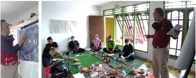
The participants’ enthusiasm for discussing the spatial planning of their village area, where fish ponds provide revenue and production was interrupted by tidal flooding, which made this discussion extremely successful. While they were conceptually unaware of SPBEA’s ecological and economic functions, the participants benefited from nearby mangroves, especially in coastal areas where mangrove conservation had been introduced. For example, a yield of mangrove crabs could be used to supplement income during the rainy season or during the low season when their ponds cannot produce an adequate yield. Thus, the participants recognized the critical role of SPBEA in ensuring the profitability and sustainability of the coastal environment.
Additionally, we promoted the Surodadi SPBEA as a rural fishing village concept. The rural fishing village maintained its culture and way of life as a coastal community reliant on aquaculture ponds. It can also serve as an ecotourism destination, thus increasing the fisheries’ productivity and income for local fishermen. Gonzáles and Antelo (2020) concur that fisheries and tourism support the local population, as a fishing village can expand as a marine tourism destination. Indeed, Rudianto and Yanuhar (2018) suggest that fishing-based coastal village planning is a method of strengthening coastal communities. Pond farmers and villagers will benefit from the lucrative program offered by an SPBEA fishing village. In addition to establishing ecotourism in the mangrove protection region, they will be able to create agritourism businesses in fishpond cultivation areas. However, without the assistance of the local government, the implementation of the SPBEA rural fishing village would have been a failure. The village leaders and pond farmers were required to present the results of the SPBEA meeting to state and provincial councils following the discussion. This would be quite a challenge for them. With the help of local partners, such as the local university or other local officials, this could be easier and more effective.
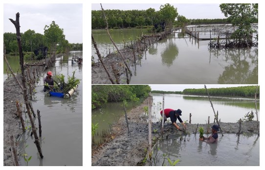
We attempted to put our rural spatial planning concept into practice on a demonstration site following a workshop discussion and exercise on rural SPBEA. Spatial suitability planning was used to implement AMA or silvo-fisheries and the development of coastal and river green belts. Mangroves were planted along the riverbank, and fish seedlings were distributed using the polyculture concept in the sample ponds belonging to the pond farming communities (see Figure 12).
However, given the project’s timeline and the fact that the presentation requires time to develop, it is doubtful that we will be able to measure the program’s performance. The alternative seems to be that the local university’s collaborators resume the initiative after the end of the project, either through updates from the farmer community or through site visits.
4. Conclusion
SPBEA is a key policy issue that must be addressed by all parties, from the government to the public as policy users and objects, including young scientists and farming communities. Before the training, it was shown that the training participants (young scientists) did not fully comprehend how SPBEA works or what approaches can be taken to apply SPBEA. Meanwhile, not everybody in the village was aware of the rural SPBEA or its potential impact on their way of life. After the workshop, they felt that this training would help them improve their understanding of SPBEA implementation in practical ways.
Given the limited time available, training had to be conducted in practical and simple ways, making it easier to understand and execute. Open-source software is recommended for potential implementation by a trainee. Likewise, direct practice makes it easier for participatory workshops to share awareness about SPBEA than ideas on paper. However, these participatory workshops need to have an adequate time for the performance assessment. Due to the limited timeline of the project, the assessment will likely be carried out by local partners such as the collaborating local university.
Additionally, the findings indicate that offline training is more advantageous than online training due to the availability of technical support and better opportunities for communication. Online training is a format that could be considered in the future. Still, it must be theoretically strengthened by restricting the optimal number of participants to ensure that the training runs successfully. We suggest that 40 people is optimal for the hybrid process, with a 3:1 ratio between online and offline participants. Additionally, future training should introduce a more stringent screening procedure to recruit highly motivated individuals who possess the necessary background knowledge. The attractiveness of the training should be increased by having internet fees covered and providing benefits to those who attend and providing immediate backup tutorials to those who experience network delays.