Plausible alternative future of mangroves and their ecosystem services: Case studies from Asia-Pacific region
Keywords
Ecosystem services · Land change simulation · Mangrove · Scenarios · Sustainable development
HIGHLIGHTS
- Landscape scenarios are developed across two mangrove sites.
- Vital ecosystem services are simulated across different scenarios.
- Evidence-led policy planning guidelines are developed.
1. INTRODUCTION
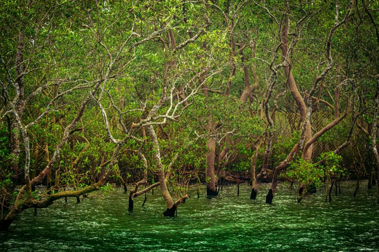
Mangrove forests are situated at the interface between land and sea and provide a plethora of vital ecosystem services, like disaster risk reduction, water purification, nutrient recycling, control of soil erosion, habitats for fish and many more (Dasgupta et al., 2022). Some estimates suggest that these forests provide nearly 70 ecosystem services which are directly and indirectly related to human well-being in low-lying coastal areas (Bimrah et al., 2022). Thus, these forests play a critical role in ecosystem-based adaptation–a strategy that seeks the wise use of ecosystem services to negate climate change impacts. However, globally, mangrove forests are under threat from various social and environmental factors. This includes, but is not limited to, sea level rise, direct deforestation for agriculture and aquaculture, rapid coastal urbanisation and infrastructure development. Historically, the global mangrove cover used to be around 200,000 km2; however, they suffered severe deforestation and degradation over the past decades, especially in developing and least-developed countries (Dasgupta et al., 2022). As a common pool resource, mangroves have undergone severe deforestation over the past decades. The current extent of mangroves is about 148,000 km2, and according to the United Nations Food and Agricultural Organization (FAO), the rate of mangrove deforestation, despite the recent slowdown, continues to be alarming, especially in the Asian developing countries.
Asia, particularly South and Southeast Asia, comprises around 40% of the existing global mangroves. Among the countries, Indonesia has the highest extent of mangroves, followed by Malaysia (3.7%), Myanmar (Burma) (3.6%), Bangladesh (3.2%), India (2.7%) and the Philippines (1.9%) (DasGupta & Shaw, 2013). In Asia, mangroves spread over large river deltas, particularly in large deltas, namely the Ganges–Meghna–Brahmaputra (GBM) delta in India and Bangladesh, and the Irrawaddy Delta in Myanmar. These deltas are known to be the largest habitat of mangroves and show exceptional diversity of salt-tolerant species. Although historically, these deltas underwent massive mangrove deforestation, owing to recent global attention to mangroves and subsequent changes in national-level policies and priorities, these mangroves have been brought under strict legal protection. For instance, according to Giri et al. (2007), despite the high density of the human population in the vicinity, the mangroves of Sundarbans have not suffered much degradation over the past three decades. Nonetheless, while larger patches of mangroves are better conserved today, the smaller patches of mangroves continue to suffer severe degradation, particularly owing to a lack of legal protection. The main drivers are increasing populations and unprecedented development in coastal areas. The uncertainty attached to this rapid and mostly unplanned development is so immense that it is difficult to precisely determine the availability of the future extent of mangroves and their ecosystem services. This uncertainty also hinders integrating mangrove ecosystem services, which is important to develop an ecosystem-based adaptation (EbA) strategy. At the same time, EbA remains crucial, considering many Asian developing countries lack the economic and technical capacity required to foster resilience in low-lying coastal areas.
1.1. Scenario analysis for decision-making under uncertainty
Over the past decades, scenario analysis evolved as an important decision-making tool to manage environmental uncertainty. Scenario analysis involves both scenario development and analysis of plausible alternative futures, keeping the major uncertainties in mind. Since establishing the Intergovernmental Science-Policy Platform on Biodiversity and Ecosystem Services (IPBES), scenario analysis has been widely advocated to design a sustainable future of biodiversity and ecosystem services. Scenarios rely on a coherent and internally consistent set of assumptions and portray a spectrum of imaginative futures. These plausible alternative futures can identify conservation opportunities and analyse policy alternatives (DasGupta et al., 2019). Scenario exercises are recommended by the IPBES to mitigate the loss of biodiversity and ecosystem services.
In conventional scenario analysis, policy planners develop Business-As-Usual (BaU) scenarios and plausible alternative scenarios, depicting the best possible, the worst and several intermediate scenarios. Likewise, ecosystem services can be optimised using spatial and non-spatial Scenarios to address the synergies and trade-offs in land development and ecosystem management. Scenario analysis is an important tool for managing uncertainties. However, despite several intergovernmental bodies like Intergovernmental Panel on Climate Change and IPBES calling for scenario analysis for optimising land development in ecologically sensitive areas, there is still a dearth of case studies depicting scenario exercises related to biodiversity and ecosystem services (Hashimoto et al., 2019).
This science bulletin aims to document a new scenario-based quantification method for mangrove ecosystem services, specially customised for vulnerable small patches of island mangroves in the Asia-Pacific. Here, we discuss how state-of-the-art geospatial tools have been used for Scenario building and analysis for assessing the likely changes in current and future mangrove ecosystem services. In this article, we discuss two case studies, namely Tamsui River Estuary in Taiwan and Bhitarkanika Mangroves in Orissa, India, where we developed future scenarios for mangroves under alternative development pathways and analysed the availability of vital mangrove ecosystem services.
2. METHODOLOGY
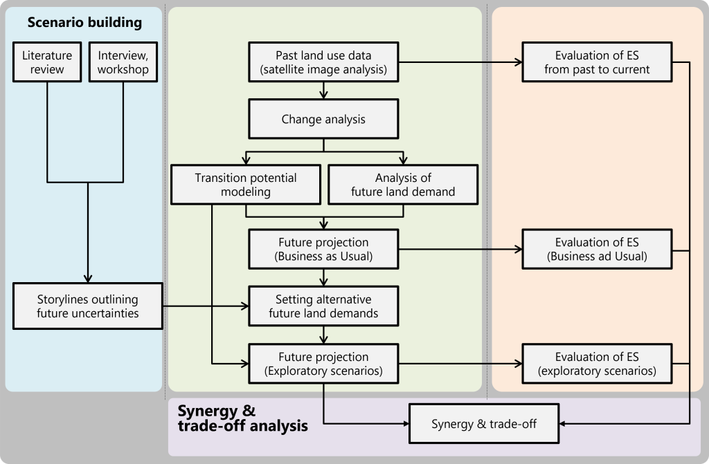
In this project, we have used a scenario-based ecosystem services quantification tool. We have adopted the Story and Simulation Approach (SAS) suggested by Alcamo (2008), which consists of developing a robust storyline about the likely uncertainties. In the second part, using the key drivers identified in the SAS approach, either obtained from literature or participatory exercises, we simulated the land use for 2050. Based on these plausible alternative land use scenarios, we evaluated the likely state of vital ecosystem services (e.g., carbon storage, nutrient recycling, sediment trapping, habitat quality, etc.) using the InVEST model. InVEST is a set of biophysical models that consists of blue carbon, sediment retention and many others (https://naturalcapitalproject.stanford.edu/software/invest). It operates on different site-specific spatial and non-spatial information. The methodology is summarised in the following in Figure 1.
3. CASE STUDY 1: QUANTIFICATION OF MANGROVE ECOSYSTEM SERVICES THROUGH EXPLORATORY SCENARIOS IN TAMSUI RIVER ESTUARY IN TAIWAN1
3.1. Introduction to the Tamsui River Estuary, Taiwan
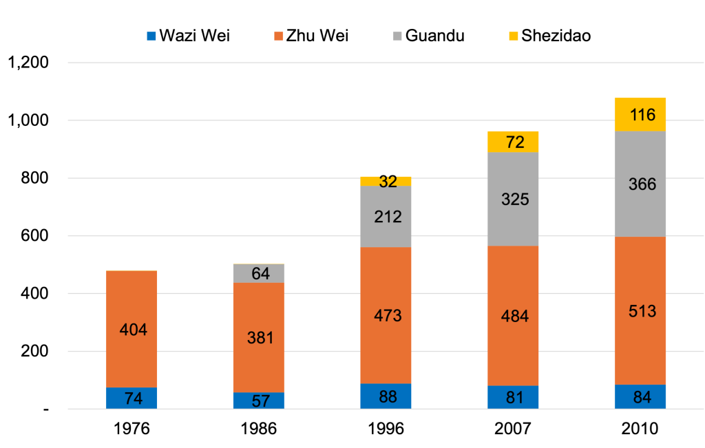
Taiwan’s mangroves are mostly located on the estuary of the west coast. A considerable amount of mud is deposited in the estuary area on Taiwan’s western coast, which is ideal for the growth of mangroves. The Tamsui Estuary’s mangroves are mostly found in four areas, namely Wazi Wei, Zhu Wei, Guandu and Shezidao (Figure 2a). Mangrove areas have gradually risen in recent years because of the government’s aggressive conservation initiatives (Wang et al., 2015) (Figure 2b). However, the Tamsui River basin region has a population of approximately 8 million people (more than 30% of the national population) and is highly developed in industry and trade. This brings significant uncertainty in the future extent of mangroves.
3.2. Scenario development
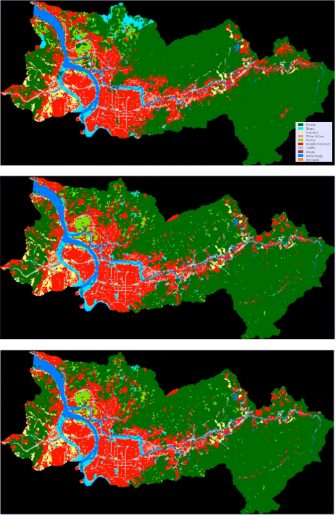
Land demand is generally proportional to population size. The population in the study region is expected to reach 7.26 million in 2035 and then decline to 6.61 million in 2050. However, the urban decline is not expected to occur in the target projection year of 2050. Continuous depopulation has a huge impact on future land demand since land usage translates into human activity, especially in the development of cities. Thus, we studied the transition from 1994 to 2007 and produced a (BaU) land use prediction for 2050. Also, mangrove forests are simulated with two alternative land use Scenarios for 2050. In Scenario 1 (S1), mangrove forests are projected to be transformed into grassland and in Scenario 2, mangroves are projected to be turned into water bodies (Figure 3). The LCM, which was used to develop the spatial scenarios considers the dominant land use changes over a time-series period. We used the land-use transition from 1994–2007 to locate the dominant changes. Based on the findings, three plausible alternative future Scenarios, i.e., BaU, S1 and S2 were developed.
3.3. Scenario analysis
The three plausible alternative land use scenarios are developed which are furnished in Figure 3. According to the BaU findings, when comparingland use to 2007, forest and residential land will increase, whereas grass, other urban, paddy and wasteland use will decrease. Due to the protection restrictions that forbid the development of mangroves, there will still be 92 hectares of wetland (mangrove forest) in 2050 BaU. Eighty-six hectares of wetland were turned into grassland in S1 and 86 ha into a body of water in S2. In summary, these projection findings demonstrate that the influence of policy interventions resulted in land use conversion, demonstrating the tangible implications of our scenario settings in this model.
3.4. Scenario analysis of vital ecosystem services
We utilised InVEST models (carbon storage, habitat quality, nutrient retention and sediment delivery) to evaluate the ecosystem services in the study region after assessing the data on land-use changes and land-use projections.2 The following figure shows the changes in the study region during the previous 24 years and the upcoming 32 years. We specifically looked at carbon storage, habitat quality, nutrient recycling and sediment retention services, as these consist of important mangrove ecosystem services. The regional distribution of ecosystem services is shown. The average ES value for each raster cell in three different future scenarios (BaU, S1 and S2) and historical land usage (1997, 2006 and 2018) are shown in Figure 4.
Overall, the study area’s ecosystem services, such as carbon storage and habitat quality, showed a slight increase, indicating a gradual improvement in environmental quality. Toward 2050, nitrogen retention and the ratio of sediment delivery tended to decrease. An evident change in carbon storage was also strongly correlated with the amount of forest land among the ecosystem services. The forests surrounding the Tamsui River basin have a high capacity for storing carbon and the amount of carbon in the ecosystem changes as the forest area grows. This is primarily because the urban plan places a high value on protecting catchment areas, which have converted a lot of wasteland and paddy fields into forests. It was observed that carbon storage in 2050 BaU would be higher than in 2018; BaU land use with a mangrove convention policy has the highest potential for carbon storage when compared to 2050 S1 and 2050 S2. Similarly, BaU land use is evaluated as the best for improving habitat quality than past land uses; however, the mangrove convention seems unchanged across the three scenarios, possibly owing to the smaller patch of existence and the fact that it is well covered under the current policy guidelines.
3.5. Policy recommendation
The processes of urbanisation in the Taipei Metropolitan area significantly impact mangrove forests in the Tamsui River Estuary. In the past, the Taiwanese government used urban and regional planning to preserve the land, water and overall environmental quality in the upper and middle parts of the catchment; however, with limited impacts in the lower catchment. In this research, we looked at the changes in ecosystem services as a function of land use changes over the past and in the future. The key findings include that from 1994 to 2018, these four ecosystem services experienced a decline. However, the BaU land use of 2050 is anticipated to be relatively stable, with increased forest land and decreased agricultural land. As such, the data is helpful for the evaluation of ecosystem services.
4. CASE STUDY 2: QUANTIFICATION OF MANGROVE ECOSYSTEM SERVICES THROUGH EXPLORATORY SCENARIOS IN BHITARKANIKA MANGROVES IN ORISSA, INDIA3
4.1. Introduction to the Bhitarkanika Mangroves, Orissa, India
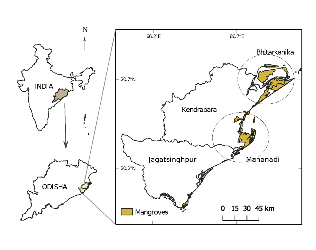
The Bhitarkanika and Paradip mangroves are among the important mangrove habitats on the east coast of India. Over the past decades, it has faced tremendous pressure from industry and other forms of coastal development. As a result, the mangrove extent was reduced significantly. According to the Census of India (2011), approximately 400 villages within the Bhitarkanika National Park and approximately 1,50,000 people living in these directly or indirectly depend on the mangroves. Figure 5 depicts the location of the study area.
4.2. Scenario development from the participatory survey
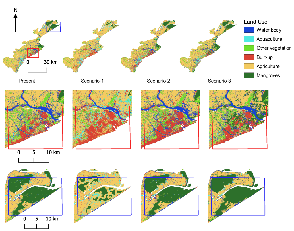
To determine the plausible alternative futures of mangroves in these two study areas, we ratified the story and simulation approach, a common method used for scenario building. We first conducted a participatory survey to identify the key drivers and uncertainties associated with it.4 This served as the basis of the storyline development. After providing a summary of the perceptions held by stakeholders regarding the region’s future landscape, this study produced three scenarios based on the region’s economic development. LCM was used for the first scenario, i.e., Scenario 1, where economic growth gets the highest priority. In other words, the local government prioritises the expansion of the built-up area, agricultural farms and aquaculture. In Scenario 2, the conservation of mangroves is taken care of, although development continues. Lastly, Scenario 3 portrays an ecologically optimistic future characterised by the reverse conservation of aquaculture, agriculture and other vegetated areas. Under this scenario, it is considered that mangrove conservation and regeneration will be prioritised owing to changed government policy.
4.3. Scenario analysis
Scenario 1 is dominated by agriculture, aquaculture cover and built-up expansion. Expectedly, mangrove cover has decreased by 2.5% in this scenario from the current extent and built-up areas expanded from 4.5% to 9.5%. The land use pattern for Scenario 2 reflects similar changes, with the mangrove cover remaining unchanged at 9.1%. In contrast, the mangrove cover in Scenario 3 rises from 9.1% to 14.1%, owing to extensive plantation-based restoration. Figure 6 provides the alternative land use maps for 2050.
4.4. Scenario analysis for vital ecosystem services
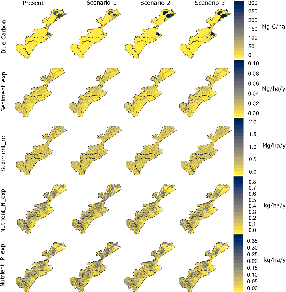
This research focused on four ecosystem services types: blue carbon, nitrogen and phosphorus retention and sediment transport.5 The findings indicate that the loss of mangroves resulted in a net emission of blue carbon in scenario 1. In scenario 2, changes in mangrove cover are insignificant, while an increased mangrove cover in scenario 3 will boost blue carbon to 6.10 Tg C. Similarly, sediment export will marginally increase to 1.99 Gg/y in Scenario 1, mainly due to the loss of mangroves. On the contrary, sediment transportation will decrease in Scenario 2 and a further decrease in Scenario 3. As mangrove cover loss is also directly proportional to N and P nutrient exports, in Scenario 1, the export is likely to increase to 41.58 and 18.83 Mg/y, respectively. However, in the alternative scenarios (i.e., both Scenarios 2 and 3), it is expected to be even lower than the baseline (see Figure 7).
4.5. Policy recommendation
Mangrove ecosystems provide many ecosystem services essential for controlling coastal environments. This study developed three potential alternative scenarios based on which ecosystem services of mangroves were quantified. The research explored that, in the worst case, the state of Odisha is likely to release 2.16 Tg C by 2030, which is undesirable. On the other hand, under the best-case scenario, Mangroves can potentially absorb an additional 1.55 Tg C of carbon dioxide from the atmosphere. Furthermore, conservation co-benefits include lower exports of sediment and nutrients, which are pivotal for an ecosystem-based adaptation in the region.
5. CONCLUSION
Mangroves are finite and fragile resources and there is a global consensus that these forests should be conserved and restored, given that the coastal areas face unprecedented risk from climate change. This paper presented two case studies where we developed landscape-scale scenarios and quantified the state of mangrove ecosystem services across plausible alternative development pathways. The scenarios identified a range of possibilities, including the best and worst-case scenarios. At the local scale, these case studies would be helpful for policy planners to optimise their development plan spatially to balance the synergies and trade-offs in vital ecosystem services. The methods adopted in this study should further inspire researchers to adopt a similar approach to scenario-based quantification of mangrove ecosystem services in Asia and elsewhere. Nonetheless, the study has certain limitations, e.g., the models we used are not conducive to calculating the impacts of sea level rise of the prime determinant for future mangrove ecosystem services. In addition, large-scale natural hazards also alter mangrove habitats drastically; however, such uncertainties were not considered during our simulation.
6. ACKNOWLEDGEMENT
This research work is supported by the Asia-Pacific Network for Global Change Research (APN) under the Collaborative Regional Research Programme (CRRP) with grant number CRRP2018-03MY-Hashimoto.
NOTES
This is a summarized version. For details see Chung et al. (2022).
For the details of model set up and boundary variables, please see Chung et al. (2022).
For details, see Kadaverugu et al. (2022).
For details, please see Dhyani et al. (2022).
For details on InVEST modelling, see Kadaverugu et al. (2022).