
Potential of agroforestry for climate change adaptation in the Northwest mountainous region of Vietnam
Keywords
Agroforestry · Climate change · Da River headwater · Vietnamese northwest mountainous region
Highlights
- The Northwest region of Vietnam’s local community is highly susceptible to the adverse effects of climate change, particularly given the region’s socioeconomic characteristics. Nevertheless, the community’s knowledge and understanding of this matter remain insufficient.
- In order to achieve sustainable food security for the region under a changing climate, farmers and policy planners need to consider certain climate change adaption and mitigation measures.
- Agroforestry practices can be promoted as a climate change adaptation measure for the region, built upon existing agroforestry models practised in the region.
1. Introduction
The climate has been changing more rapidly and its negative impacts have become even more widespread in the last few decades (IPCC, 2022). The best estimate of temperature increase is approximately 1.8–4 °C in 2090–2099 compared to 1980–1999, with the specific increase depending on future greenhouse gases (GHGs) emitted into the atmosphere (IPCC, 2007). The impacts of climate change are localised – different regions would suffer from heat, drought or flooding events at different times. These increasingly frequent and extreme climate events are resulting in catastrophic consequences, particularly for agriculture and food security (IPCC, 2022).
Mountainous agricultural areas, as well as the communities whose livelihoods depend on them, are highly vulnerable to the impacts of climate change (Bandara et al., 2021; IPCC, 2022). The impact on specific locations would vary depending on many factors, such as topographic and social structures, land use, level of soil erosion and farming traditions. To develop the capability and acceptance of climate-intelligent technologies and practices among farmers in specific regions, gaining insights into their understanding of climate change is crucial. Planning and programs for agriculture in these areas should also take into account the impacts of climate change and associated issues, such as the risks posed, the long-term effects, technologies that communities can adopt and attitudes toward changing farming practices.
Among the land use practices that have been promoted as adaption strategies for climate change, agroforestry has the potential to be one of the most suitable systems for the region which is the subject of this study – the mountainous Northwest region of Vietnam. The World Agroforestry Centre (which used to be The International Centre for Research in Agroforestry, as cited in Nair (1993)) defined agroforestry as follows: “Agroforestry is a collective name for land-use systems and technologies where woody perennials (trees, shrubs, palms, etc.) are deliberately used on the same land-management unit as agricultural crops and/or animals, either on the same form of spatial arrangement or temporal sequence. In agroforestry system there are both ecological and economical interactions between the different components.” Agroforestry, which involves the integration of woody perennials and crops or animals on the same land management unit, has been practised in the region for a significant period of time as a strategy to enhance land use management and boost income generation (Martin et al., 2020). With necessary adjustments, the practice can also be employed to help local communities impacted by the negative effects of climate change and support their agriculture production (Charles, Nzunda, & Munishi, 2014; Tschora & Cherubini, 2020; Udawatta & Jose, 2021). There is a need for more research and adoption of the most suitable agroforestry models for the region’s climate and population.
The present paper begins by introducing the characteristics of the Vietnamese Northwest region, specifically the Da River upstream catchment, in Section 1. Section 2 provides an overview of the intricate relationship between mountainous farming systems and climate change in Northwest Vietnam. In Section 3, we present some results from our work with local communities on issues related to climate change and discuss which farming models should be adopted to adapt to the changing local weather patterns.
2. Methodology
We conducted a comprehensive review of peer-reviewed articles and scientific reports on climate change and extreme weather events in the Da River upland area and the Northwest region of Vietnam in both Vietnamese and English. Our search was based on keywords such as “climate change,” “Vietnamese northwest mountainous,” “Da river upland,” “climate change adaptation,” and “agroforestry.” We extracted relevant information, including meteorological monitoring data, to compare the recent climate regime (2010-2020) with the climate regimes of the past 30-50 years.
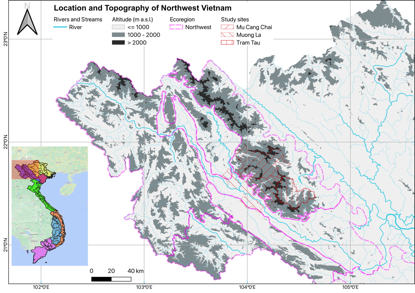
We used a random stratified sampling technique to select our samples for our study. Specifically, we chose three districts, Mu Cang Chai, Tram Tau, and Muong La, which are significantly exposed to extreme climatic events, as our study sites (Figure 1). From each district, we selected one commune that represents the typical topographic, ethnic and land use characteristics of the area (Figure 2).
During our project, we conducted group discussions in each commune with 15 participants, including both men and women of mature age who had been living in the area for at least five years. The questions posed during these discussions were:
- Have there been any changes in climate characteristics in the areas?
- If yes, what were these changes?
- How have these changes affected your household farming activities?
- How have these changes affected natural resources (e.g., soil, water, forest, wildlife) which related to your everyday life & farming activities?
The results of these discussions confirmed the findings in the literature.
3. Results and Discussion
3.1 Characteristics of the Vietnamese Northwest region
The Da River, also known as the Black River, runs through China, Laos and Vietnam. Half of the basin originated from the river (Da River basin) in Vietnam’s territory in the Northwest. The Northwest region, including Hoa Binh, Son La, Lai Chau, Dien Bien, and the western part of Yen Bai and Lao Cai provinces, also lies within Da River Basin. The river serves as the main water supply for agriculture in 25 provinces and cities in Vietnam and is the primary source of drinking water for a population of more than 30 million people (Vietnamese Government, 2010).
The river is also the major water supply for about 40 small and large hydroelectric power plants, including Vietnam’s three largest hydroelectric power plants (Son La, Hoa Binh, Lai Chau). These power plants also serve as reservoirs for flood control, making them critical for the region’s rural development. Thus, any impact of climate change on this area will have long-lasting and far-reaching consequences for the local population and surrounding regions.
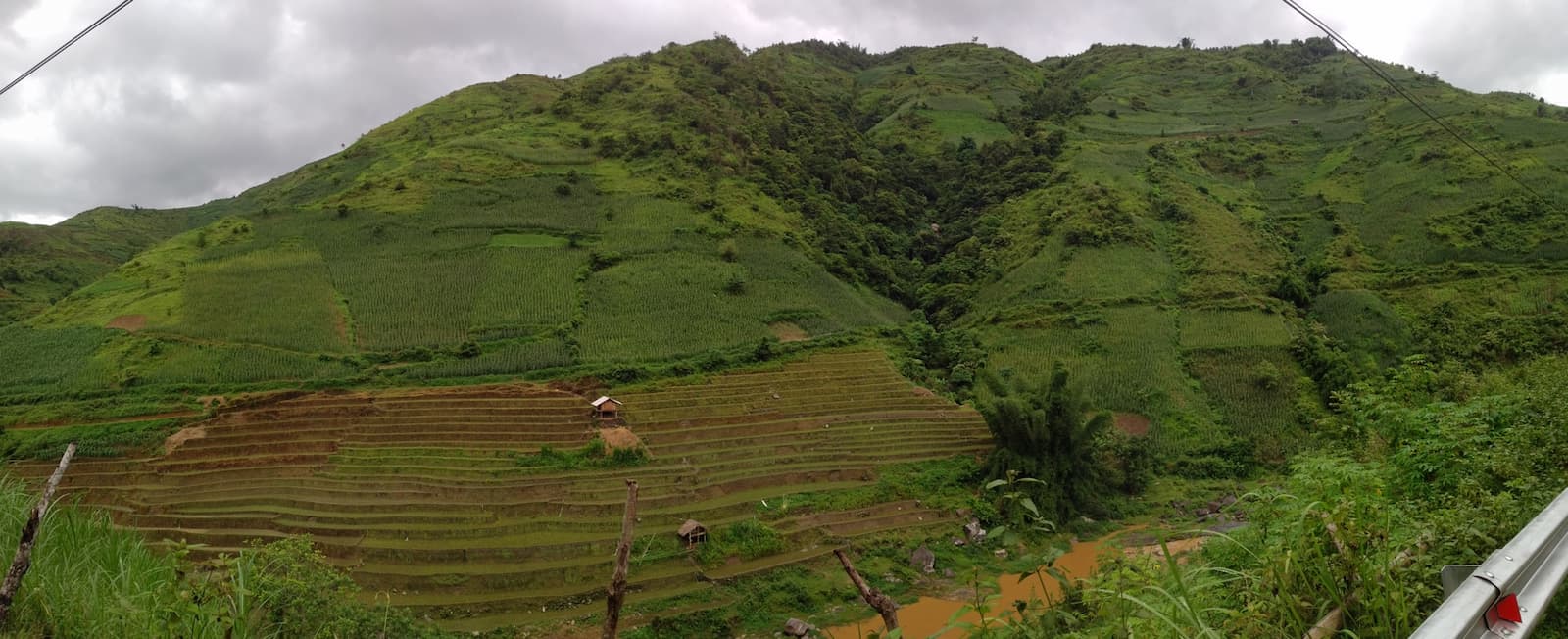
The dominant annual crops across the Northwest provinces are maize, rice and cassava (Vietnam General Statistics Office [GSO], 2022; Zimmer, Thi, Lo, Baynes, & Nichols, 2017). (Figure 2) Common agriculture practices include shifting cultivation with very short fallow periods (3 years maximum), monoculture cultivation of annual crops and agroforestry in the form of homegardens. Intensive agricultural practices resulting from population growth and government policies can lead to problems such as decreased production and soil erosion (Nguyen, Whelan, & Nichols, 2022; Zimmer et al., 2017). For several years, according to the poverty and multidimensional poverty index, the region has recorded the highest rates of poverty among households (Table 1).
|
Region |
Province |
Year |
||||
|
2016
|
2017
|
2018
|
2019
|
2020
|
||
|
Vietnam
|
9.20
|
7.90
|
6.80
|
5.65
|
4.80
|
|
|
Northern Midland and Mountainous regions
|
23.00
|
21.00
|
18.40
|
16.43
|
14.38
|
|
|
|
|
|
|
|
|
|
|
Northeast |
Ha Giang |
39.80 |
36.90 |
32.60 |
29.11 |
26.98 |
|
Cao Bang |
37.30 |
34.90 |
31.50 |
28.53 |
25.97 |
|
|
Bac Kan |
29.70 |
27.70 |
25.10 |
22.53 |
21.47 |
|
|
Tuyen Quang |
22.00 |
19.60 |
17.50 |
15.11 |
12.90 |
|
|
Thai Nguyen |
7.80 |
7.40 |
6.00 |
5.09 |
4.09 |
|
|
Lang Son |
23.50 |
20.60 |
18.40 |
15.90 |
12.26 |
|
|
Bac Giang |
6.40 |
5.40 |
3.80 |
3.29 |
2.81 |
|
|
Phu Tho |
10.30 |
9.20 |
7.50 |
6.53 |
5.84 |
|
|
|
|
|
|
|
|
|
|
Northwest |
Lao Cai |
26.40 |
23.90 |
20.50 |
17.24 |
15.38 |
|
Yen Bai |
26.10 |
23.60 |
20.30 |
17.47 |
15.06 |
|
|
Dien Bien |
53.90 |
50.20 |
44.50 |
39.85 |
36.74 |
|
|
Lai Chau |
44.30 |
41.60 |
37.10 |
33.04 |
30.83 |
|
|
Son La |
42.80 |
41.00 |
36.30 |
33.01 |
30.53 |
|
|
Hoa Binh |
17.80 |
15.40 |
12.70 |
10.50 |
9.09 |
|
Source: GSO, 2022
In addition, the diverse ethnicity of the region makes it more vulnerable to climate change. Seventy percent of the population of the region belongs to an ethnic minority (in Vietnam, the ethnic majority is “Kinh”) (World Bank, 2009). The main ethnic groups are Muong, Hmong and Thai. Hmong people mostly live in the higher elevation section of the mountains, while Thai and Muong people usually live in the lower sections. The majority of these communities face significant challenges due to low incomes and inadequate access to essential services (GSO, 2022). As a result of inadequate infrastructure, outdated farming methods, and natural disasters like floods and landslides, these communities have frequently suffered from severe food shortages and low-quality food. Much research has emphasised the difficulties of breaking the vicious cycle of population growth, leading to pressure on the environment and increasing poverty (Le & Tran, 1995). Overall, local agriculture activities depend largely on weather conditions. Due to a lack of knowledge about climate change, the local communities are failing to adapt and mitigate its impacts (Isabel, 2010).
3.2 Climate change’s impacts on the region
We interviewed three groups of people from the local communities in Nam Pam (Muong La District, Son La Province), La Pan Tan (Mu Cang Chai District, Yen Bai Province) and Ban Mu (Tram Tau District, Yen Bai Province). The group in Nam Pam commune consisted of Thai and Hmong people. The two remaining groups were Hmong people.
The interviews focussed on how much local people know about “climate change” (“Biến đổi khí hậu” in Vietnamese; “Phạ lét lôm piến máư” in Thai; “Lub ntxug ib ntxhaav” in Hmong). Overall, most respondents did not know about the concept of climate change. However, they have observed many changes in the local weather recently, including:
- longer summers, shorter winters;
- annual temperatures have increased with hotter summers, warmer winters;
- unpredictable rainfall – larger amounts of rainfall for longer periods, resulting in flash floods and landslides at unprecedented levels;
- extreme/severe drought; and
- other extreme weather events such as cold spells, ice freezing in winters (Figure 3 ) and dry spells have all occurred with higher frequencies, increased magnitude and longer duration.
In their opinion, the weather becomes more and more unpredictable, leading to significant changes in plant phenology, such as multiple flowering in the years but no or little fruiting for perennial plants (e.g., peach, plum), earlier flowering for annual plants.
Such experience was also confirmed in climate data from meteorology stations across the region (Table 1; MONRE, 2016; 2021). The effects of climate change in Vietnam are most evident in the characteristics of the number and frequency of storms and tropical depressions hitting the region (MONRE, 2021). Only in Yen Bai province, in 2015, there were 23 storms and tropical depressions; in 2018, there were particularly, storms and tropical depressions from 2008 to 2020 had unusually greater frequencies and unpredictable characteristics, thus making it very difficult to prevent and respond. These storms and tropical depressions occurred in high mountain areas such as Mu Cang Chai, Tram Tau and Muong La, causing a number of severe flash floods and landslide occurrences in the seasons. Such occurrences were considered as typical and tangible evidence of climate change (MONRE, 2021).
|
|
Period |
Vietnam |
Northwest region |
||||
|
Average |
Max |
Min |
Average |
Max |
Min |
||
|
Total hot days per year |
1961-2018 |
21(0÷85) |
50(0÷148) |
5(0÷36) |
15(0÷42) |
43(0÷129) |
3(0÷18) |
|
1981-2010 |
21(0÷86) |
42(0÷148) |
7(0÷46) |
15(0÷41) |
31(0÷85) |
6(0÷21) |
|
|
1999-2008 |
19(0÷79) |
31(0÷105) |
10(0÷51) |
13(0÷38) |
22(0÷60) |
6(0÷21) |
|
|
2009-2018 |
27(0÷89) |
47(0÷129) |
14(0÷62) |
19(0÷57) |
41(0÷129) |
7(0÷33) |
|
|
|
|
|
|
|
|
|
|
|
Total extreme cold days per year |
1961-2018 |
46(0÷182) |
9(0÷117) |
25(0÷145) |
45 (13÷128) |
73 (35÷150) |
17 (0÷78) |
|
1981-2010 |
44(0÷162) |
12(0÷117) |
24(0÷145) |
43 (13÷126) |
69 (30÷149) |
23 (1÷107) |
|
|
1999-2008 |
37(0÷160) |
15(0÷129) |
22(0÷144) |
42 (13÷120) |
61 (23÷136) |
31(3÷107) |
|
|
2009-2018 |
38(0÷182) |
12(0÷122) |
22(0÷140) |
39 (9÷114) |
61 (15÷138) |
24(2÷97) |
|
|
|
|
|
|
|
|
|
|
|
Total extreme heavy rain days per year |
1961-2018 |
0 (2,6÷28) |
0 (7÷43) |
0(0÷14) |
6.1 (2,6÷11) |
14 (9÷25) |
0.9 (0÷4) |
|
1981-2010 |
0 (2,6÷27) |
0 (7÷43) |
0(0÷14) |
5.9 (2,6÷11) |
13.3 (7÷25) |
1 (0÷4) |
|
|
1999-2008 |
0 (3,4÷27) |
0(7÷37) |
0(0÷20) |
6.7 (3,4÷14) |
12.6 (7÷25) |
2.1 (0÷8) |
|
|
2009-2018 |
0 (2,4÷25) |
0(5÷34) |
0(0÷17) |
6 (2.4÷11) |
11.1 (7÷15) |
1.9 (0÷7) |
|
Source: MONRE, 2021.
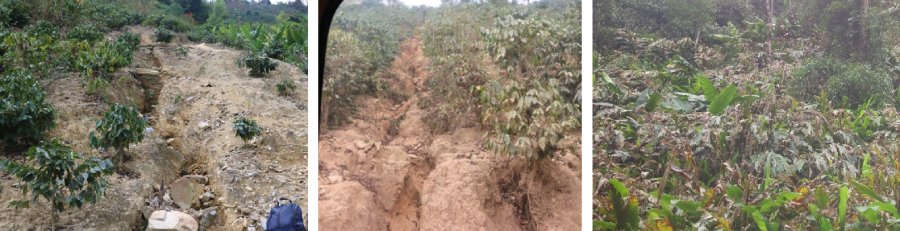
Changes in rainfall regime are one of the factors that accelerates erosion. (Figure 3) A study on one stream basin of Da river in Hat Lot commune, Mai Son District, Son La Province (Nguyen et al., 2022) concluded that soil erosion was caused by the practice of fallow farming and increasing deforestation. On the other hand, farming with adequate technology in uncultivated land might help prevent soil loss. The authors did not analyse the contribution of climate regime changes that led to more susceptibility to soil erosion in Mai Son. The Revised Universal Soil Loss Equation (RUSLE) estimates soil erosion by taking into account several factors, including rainfall, slope length, slope steepness, soil cover, erosion control practices and the soil’s erodibility factor. Together with conversion of forest land to cropland (cover factor), climate change likely contributes to the change of rainfall cycles, leading to the increase of soil erodibility (rainfall increased in the rain season), longer dry season, wetter and more extreme rainfall in the rain season. In the future (2021–2100), using a dynamical downscaling model for greenhouse gas concentration scenario RCP4.5 for the Da river basin, rainfalls were predicted to become more frequent and in larger amounts in some provinces (Son La and Lao Cai) while become lighter in some others (Lai Chau and Yen Bai) (Hồ, Trịnh, Đỗ, & Nguyễn, 2019). A study (Huong, Bo, & Fahad, 2019) explored the possible connection between the changes in rainfall and temperature and the net income of the local population in Northwest Vietnam. It was found that an increase in temperature and the amount of rainfall may have a negative impact on household net income. Particularly in the dry season, when temperature and rainfall increased, the household income declined and was projected to continue to decline by 17.7% and 21.28% in 2050 and 2100, respectively, if no climate change adaptation measures were employed.
3.3 Adaptive farming systems across the landscape
As discussed above, agriculture is the main economic activity and the main source of income for the Vietnamese Northwest mountainous region (ILRI, 2014). Climate change poses one of the biggest challenges to the agriculture sector of the region, as well as a significant barrier to sustainable agricultural production and food safety for the local communities. To achieve sustainable food security under a changing climate, farmers and policy planners need to consider certain climate change adaption and mitigation measures.
Climate smart agriculture (CSA) comprises a series of farming practices that have the potential to address challenges caused by climate change (FAO, 2013). These include water shortages for irrigation systems, soil loss, weeds and pests, among others. CSA practices include recycling of water, rotation of crops, farming diversification, agroforestry, among others (Bai et al., 2019).
Agroforestry is the combination of various types of woody vegetation, such as trees and shrubs, with crops or livestock at the same location. This system intends to diversify production sources for the owners, and the interaction between different elements should bring about various environmental, social, economic and financial benefits. Different combinations constitute different types of agroforestry, including agrosilvipasture (trees, crops and livestock), forest farming (crop or livestock and trees), urban agroforestry, i.e., homegardens (trees with crops close to homestead), among others.
Agroforestry was first deemed a promising approach for ‘land sparing’, soil conservation and resource-use efficiency. The practice itself is not new, having been employed by the local communities in the Vietnamese highland regions for decades through various traditional forms such as a combination of livestock–fishpond–garden–forest or fruit–forest plantings. The practice has been promoted to improve economic activities and income for small households (FAO, 2013). In the age of climate change, an agroforestry system that consists of trees and crops in the same area may serve as a sustainable CSA initiative that enhances the climate resilience of farms, reduces GHG emissions and increases productivity.
Applying suitable agroforestry models in an area of land or a landscape is key to sustainable development in rural highland Vietnam. Many national and international programs have been conducted in northwest Vietnam to promote agroforestry systems suitable for the sites (Mulia et al., 2020). In the context of climate change, suitable systems should be climatic and topographically resilient (such as plant species/varieties), resilient to drought, colder and hotter weather, as well as well adapted to changes brought about by the new climate regime, resistant to floods or able to prevent landslide or soil erosion (Crowther, Zimmer, Thi, Quang, & Nichols, 2020; Noordwijk et al., 2021).
Increasing the cultivation system’s resilience will make the household and local economy more stable and take less time to recover from natural disasters. Diversifying crops agroforestry is a farming technique that has the potential to enhance both carbon sequestration and crop yields. Various studies (Noordwijk et al., 2021; Simelton, Dam, & Catacutan, 2015; Vernooy, 2015) found positive results for households that employed crop diversification. Such households recovered quicker from disastrous weather events with better yields than those who employed monoculture farming. Their crops also show more resilience to changes in the climate.
Many different agroforestry systems/models were adopted in Vietnam (Mulia & Nguyen, 2021; Thang, Dung, & Hoang, 2013). The difference in models reflects the difference in topographic locations, weather conditions, regional and local markets, and skills and traditions of communities and households. In general, the cultivation system is topographic driven – terrace cultivation.
Agroforestry practices can be promoted as a climate change adaptation measure for the Northwest region of Vietnam. Agroforestry models are naturally localised and could be flexibly up-scaled or down-scaled with spatially and temporally diverse methods applied for different purposes. In this region, agroforestry already exists and is currently built upon traditional local products of rice, casava, maize, homegardens with tropical and subtropical fruit trees, and industrial trees and shrubs, such as tea, coffee, avocado, plum, peach, pear, and native forest fruit trees. Taungya systems with timber trees and staple crops were popular. In the Northwest highland region, Docynia indica (also known as Son tra or Tao meo in Vietnam, Assam apple/wild apple in India, In-sein in Myanmar and Douyi in China (Muchugi et al., 2021)) has been domesticated and considered as one of the most important and common species in agroforestry systems for decades (Mulia & Nguyen, 2021).
At the three sites that the project team visited, there were terrace rice fields where people could manage water resources, then dry rice fields, maize or casava was usually at the middle of the hills/mountains; natural forest or plantation was usually on the tops. The most common agroforestry system at the local/household scales in our sites were homegarden fruit trees, vegetables, spices, medicinal plants and flowers. However, homegardens differed among Thai and Hmong groups in terms of area, plant species and purpose. Usually, Thai people have larger gardens and plant more spices, medicinal and vegetables than Hmong people. Hmong people plant fruit trees or timber with forage grass in their gardens. On the field, Hmong people usually plant upland rice, maize, casava with shan tea/peach/D. indica or with pine and F. hoginsii, a valuable timber and used traditionally by Hmong people (Appendix A.1., A.3., A.4.), while Thai people plant maize, casava and plum/mango/longan/coffee or Magnoliaceae species used for timber (Michelia mediocris, Magnolia baillonii. M. balansae, M. conifera) (Appendix A.2., A.5., A.6.).
It is recommended that further studies be conducted to evaluate the effectiveness of existing agroforestry models in the region. This will help promote and expand models that are adaptable and resilient to climate change while identifying areas for necessary changes and adjustments. Additionally, it is important to provide continued training and education for the local communities on climate change and appropriate measures for mitigating and adapting to its impacts.
4. Conclusion
Based on the literature, surveys and site visits, it is evident that climate change is significantly impacting the Northwest mountainous region of Vietnam. The region is already facing numerous challenges, such as poverty and lack of education and infrastructure, and climate change is exacerbating these problems. Therefore, urgent action is needed to identify and implement adaptation measures to ensure food security and improve the livelihoods of the local communities.
Agroforestry is a promising solution for the region, as it has been practised for a long time and has shown potential to improve land use management and increase income capacity. However, further research is needed to determine the effectiveness of current agroforestry models and identify suitable and resilient practices that can withstand the impacts of climate change. Additionally, education and training on climate change and adaptive measures should be provided to the local communities to increase their capacity to adapt to a changing climate.
Acknowledgement
The authors would like to thank the Asia-Pacific Network for Global Change Research (APN; grant number ECSC2019-01-Do) and the Mu Cang Chai District Headwater Forest Protection Board for supporting our project. Our thanks also go to the local government authorities and local communities in Yen Bai and Son La provinces, Vietnam, for support in carrying out our surveys and site visits.