
Impact of climate change, climate variability and adaptation in the coastal area of Cambodia
Keywords
HIGHLIGHTS
- The coastal zones of Cambodia are vulnerable to climate change.
- Agriculture is one of the sources of income for rural livelihood in the coastal zone of Cambodia.
- Adaptive capacity seems to be low in the coastal zones of Cambodia.
1. INTRODUCTION
Global or economy-wide models are the most frequently used assessment indicating the impacts of climate change on the economy (Kikstra et al., 2021; Nordhaus, 2010, 2018). In the previous studies, these assessments were used to estimate the total impacts on poverty projected aggregate under the baseline scenario business as usual or an emission abatement path (Nordhaus, 2010, 2018; Skoufias, 2012). Although the estimation models are marginal, GDP is projected to decline to 1.5% by 2055 (Skoufias, 2012). Therefore, climate change, the environment and socioeconomics are linked together, which differ from sector to sector.
The impacts of climate change and variability on worldwide agricultural production are significantly concerning. The first concern is that human activities interfere with the ecosystem harming the Earth’s climate and threatening food security (Easterling & Apps, 2005; IPCC, 2001a, 2001b). The second concern is the potential damage of climate change impacts at the national level that may arise over the coming decades as well as globally; since the damage affects national and international policies, trading patterns, resource use, regional planning, and ultimately the welfare of citizens (Easterling & Apps, 2005; Foresight, 2011; IPCC, 2012; Skoufias, 2012). Furthermore, the susceptibility of agriculture and fisheries to climate change causes either direct or indirect impacts on the economic sector (IPCC, 2012). Also, the severity of climate change depleting natural resources as the environmental and demographic pressures will increase (Anthoff & Tol, 2014). The gradual climate change and extreme weather in recent years have hampered the progress of alleviating poverty and food insecurity, negatively affecting overall development efforts (Foresight, 2011; Skoufias, 2012). Therefore, the concern in these sectors tends to increase as the years pass as a result of rising threats to current income and consumption patterns of households and individual livelihoods. In particular, the changes in climate and weather conditions that impact the livelihoods of the households involved in agriculture and fisheries or other affected groups are frequently the way to approximate the different patterns. Furthermore, Cambodia’s National Adaptation Programme of Action (NAPA) 2006 report has prioritised the water resource sector in NAPA preparation, particularly since it affects agriculture and food security, which would affect Cambodia’s socioeconomic development (Royal Government of Cambodia [RGC], 2006). In the last few years, Cambodia’s economy is highly reliant on agriculture and fisheries, which contribute about 25% of the GDP and employ 49% of the labour force (WBG and ADB, 2021). Meanwhile, the Cambodian rural livelihood is mostly dependent on the agricultural sector, including farming, fisheries and forestry, which is directly sensitive to climate variability and change. Extreme climate change events and irregular seasonal weather patterns harm food security, infrastructure and livelihoods in rural and urban areas (Easterling & Apps, 2005). At the same time, slow onset events as a result of climate change are evident in land properties for farming and pasture, forestry, fisheries, biodiversity and ecosystems (van der Geest & van den Berg, 2021).
From a socioeconomic point of view, climate change impacts not only agricultural households in rural areas but also highly increases welfare vulnerability (Skoufias & Vinha, 2012). There are two primary ways in which environmental changes have an impact on livelihood consumption in rural areas. The first way is through their direct effect on agricultural production, which subsequently reduces income for vulnerable households. The second way is through the influence of climatic variations on the health of economically disadvantaged households. Among these households, children are particularly susceptible to these effects. This susceptibility stems from the fact that climatic changes can potentially lead to an increase in the prevalence of diseases or elevate the risk associated with exposure to significant weather fluctuations (Skoufias & Vinha, 2012).
Consequently, the impacts of climate change play out in two ways. On the one hand, they have an indirect role by influencing factors like income levels, the availability of resources, and the need for their reallocation. On the other hand, there is a direct connection between the environment and both health outcomes and consumption patterns. These combined effects ultimately determine the overall well-being of local households over any given period of time. Skoufias and Vinha (2012) indicated that an environmental shock might have an indirect impact but a direct negative impact on health. In the case of Cambodia, increasing the temperature or precipitation in different regions may show benefit or damage to crop yields, depending on the category of crops or the season that occurred (Tong, Yoshida, Maeda, & Kimijima, 2007). For that reason, changes in climate, such as temperature or precipitation, may negatively affect health conditions of households in rural areas as the higher temperature creates suitable conditions for diseases to develop (WHO, 2015).
Climate change is projected to increase the frequency of extreme events, resulting in significant alterations to Cambodia’s climate patterns, including shifts in temperature, rainfall distribution, and rising sea levels. Cambodia’s Second National Communication to the UNFCCC (NC2) examines the impact of climate change on various aspects of life in the country, revealing its potential to substantially affect both human well-being and economic growth, as well as the depletion of natural resources, as estimated by the GSSD in 2015.
The repercussions of these changes are particularly pronounced in coastal regions, where habitats, resources, and populations are experiencing considerable impact. The physical variables of temperature, rainfall, humidity, and winds are undergoing shifts. The coastal environment faces profound disruption due to rising sea levels, increased storminess, shifts in wave patterns, variations in coastal runoff, and changes in sediment loading. Previous reports from multiple countries, including the IPCC in 2001a and 2012 and Carmack, Winsor, and Williams in 2015, have highlighted these trends. The intricate web of biological changes, spanning from individual organisms to entire ecosystems, is transforming the coastal zone’s suitability for human habitation and use. Notably, small island subsistence and commercial agriculture are especially vulnerable to climate change, with rising sea levels leading to freshwater inundation, soil salinisation, and a consequential decline in water supply (IPCC, 2012).
Across the globe, coastal communities are bracing for the impacts of climate change, particularly those countries that are already deemed vulnerable to ongoing climate variability. Among the anticipated changes, the acceleration of sea-level rise stands out due to the cascading effects it triggers, such as increased flooding, coastal erosion, saltwater intrusion and ecological disruptions. As a result of these biophysical transformations, a range of socio-economic consequences is expected to reverberate throughout coastal regions. This encompasses not only declines in economic output but also dwindling ecological, cultural, and subsistence values that are tightly interwoven with these environments.
2. METHODOLOGY
The research design was divided into three phases: scoping, data collection and analysis. The sample selection, survey tool design and logistical arrangements were categorised into scoping phases. Then the training workshops on survey ethics and tools for data collectors, pre-testing of questionnaires in the field, and field surveys were categorised into the data collection phase. Finally, the performance of collected data, such as quality checking, entry, clean-up and analysis, was categorised into the data analysis phase.
Quantitative methods were used to collect the information using a structured questionnaire (tool) to survey individual households in the target areas. Thethe surveys on beneficiaries were then undertaken through face-to-face interviews. The representative samples were selected from the total samples of the target areas, indicating the whole targeted population with 95% confidence. The samples were selected from villagers living in a target area for longer than ten years using a random sampling technique with 400 sample sizes. The sites selected for the study were eight districts in the four provinces of Kep, Kampot, Preah Sihanouk and Koh Kong. The sample size was applied equally to each targeted province (100 samples/province). IBM’s statistical software, SPSS version 21, was used to analyse data, mainly descriptive statistics (frequency and percentage). Microsoft Excel was used to create tables and figures.
3. RESULTS AND DISCUSSION
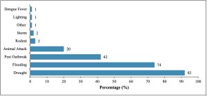
The target community responded that they were impacted by disasters and climate change. They reported negative impacts in areas such as food availability, agricultural production, health, education, dwellings and infrastructure. Multiple disasters and their impact on the community were reported during research in the target area, with at least three types of disasters being reported. Drought and floods were the most comment disasters that occurred in the target area and were reported by a majority of respondents (92% and 74%, respectively). Pest outbreaks were also recorded by 42% of respondents, followed by animal attacks at 20%. Very few (less than 5%) reported additional disaster types in the community, such as disease (particularly dengue fever), rodents, storms and lighting (storms). Regarding the frequency of occurrences encountered by households, the average number of incidents was reportedly 2 to 3 times for drought (ranging from 1 to 5 times) and two times for flood (ranging from 1 to 6 times) within the last ten years (Figure 1).
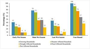
To convey the impact of disasters and climate change on agriculture production, each respondent described quantities per unit of land used for different types of agricultural activities, including rice growing, cash crop growing, vegetable growing and raising livestock. The levels of impact on each activity were estimated by comparing the production obtained in normal years and those obtained in disaster years for the same unit of land. Rice production and farming activities are the main occupations of households in the target areas, and nearly all households (97%) were reportedly engaged in rice production. There were slightly different perspectives on the definition of the rice-growing season among the farmers and research team members according to geography and their understanding of the season. To avoid ambiguity, the survey teams agreed that April to July, July to October, and October to February is the Early wet season, Main wet season, and Late wet season, respectively. In Cambodia, the farmers grow three rice crops per year depending on the accessibility of irrigation systems. In target areas, nearly half of the households (45%) grew rice only one time, 40% two times, and a minority grew three times per year. The average number of rice crops per year was 1 to 2 times per year (1.65). Most households (78%) grew rice in the main wet season (Wet Season Rice), around 45% in the Early wet season and Late wet season, commonly defined as Dry Season Rice. Most of the households (90%) that grew rice crops in any season experienced at least one disaster. Main wet season crops were reported to have the highest proportion of households affected by disaster types such as pest outbreaks. Regarding the proportion of affected land, the households that encountered disaster impacts reported that all of their lands were affected by disasters, in which 60%, 54%, and 30% of total land were affected by drought, floods and pest outbreaks, respectively (Figure 2).
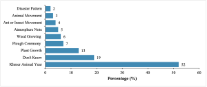
To predict the occurrence of disasters, the respondents from different target rural areas were asked to report various indigenous and technical early warning signs (EWS) and systems used in their communities and households. These predictions were mainly focused on flooding and drought, as these are common disasters in the targeted communities. Various indigenous EWS and systems were described during the survey, and confidence in EWS was highly associated with the education of the community members, their ages, localisation, and level of disaster occurrence and impact. Over 80% mentioned at least one type of EWS. This indigenous EWS, referred to as Khmer Animal Years, was commonly mentioned by over half of the households surveyed as a system to predict the occurrence of floods as well as drought. In this EWS, an animal represents each year in a twelve-year cycle. Belief in this system suggests that Flooding is likely to occur every 12 years, specifically in the year of Dragon, Snake or Rabbit. Belief in this EWS was most widespread among community elders. The Plant and Weed Growth EWS uses plants, known in Khmer as troury ampel, khvet, kantrengkhet, ampeltek, trabek and others to predict floods and drought, and was used by 13% of the households surveyed. For example, these households believed that there would be abundant rainfall when “khvet” produced many fruits. In other cases, if “knantrengket” or “rosy” had many flowers, that indicated little or no rainfall. The prediction made through the annual Plough Ceremony was believed by around 7% of households surveyed to indicate the occurrence of drought or floods as well as other phenomena. A minority of households mentioned the Insect Movement, including termites and ants, as an indigenous EWS used to predict flooding and rain, specifically termites for flooding and ants for rain. If termites or ants build a high hill for their colonies, it foretells the arrival of floods and heavy rain. Insects are believed to have special instincts related to the occurrence of floods. The Wild Animal EWS is used to predict occurrences of floods by very few households (3%). Various animal species, including satkrol and sathong, were utilised in this prediction process. According to the beliefs held by these households, flooding was anticipated when “sathong” laid their eggs atop a tree. Conversely, the occurrence of drought was predicted when specific behaviours associated with “satkrol,” such as their crying characteristics, were observed (Figure 3).
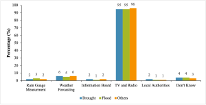
Besides traditional EWS prediction, technical EWS was also investigated in addition to the survey. In general, flooding and drought are the main disasters that can be predicted technically, leading to early alerts. The main sources to predict are water level and rainfall level, which are recorded by the Hydrology and Water Department. Then, the information was forwarded to various channels, such as television and radio to broadcast the warning altered due to the accessibility of local television and radio channels to the target communities. Despite the fact that disaster information was disseminated through radio and television on a daily basis, the individuals within the targeted communities displayed minimal interest in weather forecasts, as reported by key informant interviews conducted within the villages, as well as observations made in the field. Most households are more interested in the movie (or story) than the news (or information) since they consider that disasters rarely occur in their communities. Apart from television or radio, the minority of households (less than 10%) stated that they depended on weather forecast information from various sources to predict the occurrence of disasters. A few households in the target areas also mentioned rain gauge measurements, information boards and dissemination of community information by the local authorities (Figure 4).
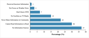
Regarding the issue of receiving EWS information about disasters, multiple problems were raised among the respondents during interviews. Many households claimed that they had no information sources (around 37%). Being unable to read the information on the board was also an issue raised by 30% of the respondents. A small number of respondents (15%) stated the primary issue was not having access to facilities, such as radio and television, or not being aware of EWS (7%) (Figure 5).
In order to address disaster risk reduction (DRR) issues, formal institutions were established from the national to commune levels, which signifies the most local government administration. The National Committee for Disaster Management (NCDM) leads the coordination of disaster management in the country. At the sub-national level, the Provincial Committee for Disaster Management (PCDM) coordinates and manages disaster response as well as DRR-related interventions with support from the District Committee for Disaster Management (DCDM) and the Commune Committee for Disaster Management (CCDM). CCDM and DCDM, as the lowest and most local administrative bodies, provide direct support for mitigating and responding to disasters in their locality.
The CCDM is chaired by the commune chief and has the role and responsibility for implementing policies related to Disaster Risk Management (DRM); disseminating disaster information to the local community; reporting to the DCDM and PCDM; conducting emergency rescues; acting as secretariat to DCDM; forming a supporting team and selecting volunteers and training the team; reporting emergencies to the DCDM and the PCDM; and planning and reporting budgets. To support CCDM, the Village Committee for Disaster Management (VCDM) was also established with key members, women members, and others. The VCDM works to share information on disasters and climate change with community members and provide communication between community members and upper authorities such as the CCDM, PCDM, and NCDM.
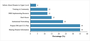
With the exception of local authorities, around 10% of all target households were highly aware of committee members in CCDM or VCDM, while over half did not know whether there was any related committee in their community. However, in cases of related activities, community members commonly targeted local authorities rather than other people. Out of the households that were aware of the committee (CCDM or VCDM), one-third reported the committee works on preparing Disaster Management (DM) and Climate Change Adaptation (CCA) plans for their village and shared disaster information with the community. Around 23% regarded the VCDM as an institutional network for their community. Regarding the work quality, 15% added that these committees were very active, while the remainder claimed not to be aware of their activities or stated that these committees were not very active (Figure 6).
4. CONCLUSION
Climate change-induced and other types of disasters, including drought, floods and pest outbreaks, were frequently encountered by the majority of households surveyed within the designated areas. These occurrences have had substantial and severe effects on these households’ lives and communal undertakings. The impacts range from the devastation of crop yields and the decline of livestock production to constraints in accessing water for household needs, the destruction of property and assets, spikes in commodity costs, and limited access to social services. The frequency, intensity and severity of these phenomena have notably increased during disaster events, and this trend is anticipated to persist in the future. It is evident from the research results that drought occurrences have the greatest impact on the economic destruction of households in the target areas due to greater frequency and higher intensity of occurrences when compared to other types of disaster. In addition, serious impacts were also reported due to flooding. Rice crop production was the most seriously affected by disasters, followed by small-scale livestock production.
Agricultural production, particularly rice crop production, was reported to be the main income source of households in the target areas. However, the researchers also documented the susceptibility of agricultural production to climate change and the negative impacts of disasters because of their dependency on natural conditions and the lack of respondents’ existing adaptation and coping mechanisms. The impact of natural disasters and climate change on household income in vulnerable areas is significant. These effects can be seen in the form of agricultural damage, depletion of natural resources, and increasingly frequent disasters. As a result, households are forced into chronic debt and must find alternative ways to generate income. These issues will continue if the household capacity and local institutional structures are not built or strengthened in terms of DRR and CCA.
Although the surveyed households experienced substantial effects on livestock production, they did not indicate the presence of any established mechanisms to manage or adapt to disasters or climate change concerning their animals. These outcomes may be attributed to the limitation of external interventions, poor availability of facilities or resources in the target community, lack of information, rarity of disaster occurrences, or economic constraints of the community to access facilities or resources. In conclusion, the local community’s capacity for resilient agricultural techniques is notably restricted and requires substantial enhancement.
5. ACKNOWLEDGEMENT
This article is based on work supported by the Asia-Pacific Network for Global Change Research (APN) under Grant No. CBA2021-11SY-Sum and the Ministry of Environment of Cambodia for in-kind contribution and coordination during the project implementation.