Engaging Young People in Community-based Flood Risk Management in Pekalongan, Indonesia
Keywords
Flooding · Indonesia · Student · Training · Vulnerability assessment · Water quality
HIGHLIGHTS
- This project helped young people build their capacity in flood risk management.
- Online lecturing, remote coaching and field activities were provided.
- The project was supported by the governments of Central Java Province and Pekalongan City.
- Learners developed hands-on skills and a better understanding of flooding impacts.
1. INTRODUCTION
Indonesia is a sprawling archipelago comprising over 17,000 islands and uniquely vulnerable to the impacts of sea level rise. Located in Southeast Asia, this tropical country is renowned for its rich biodiversity, stunning landscapes and vibrant cultures. However, it is also profoundly affected by the rising sea levels resulting from global climate change. With approximately 54,720 kilometres of coastline, Indonesia’s extensive network of islands, low-lying coastal areas and densely populated regions face an imminent threat as sea levels continue to surge (Setiadi et al., 2023; Setiadi & Frederika, 2022; Setiadi & Lo, 2019).
The primary driver of sea level rise is the melting of polar ice caps and the expansion of seawater due to increasing temperatures. These factors, exacerbated by human-induced climate change, pose a significant challenge to Indonesia’s future stability and resilience. The nation’s geographical diversity, comprising mountainous terrains and coastal plains, further complicates the impact of rising seas. While mountainous regions may experience increased flooding downstream, coastal regions are particularly susceptible to inundation, saltwater intrusion, and erosion, which threaten the livelihoods and homes of millions of people.
Pekalongan is one of the most climate-sensitive cities in Indonesia. It is a secondary city in the Central Java Province with a total land area of approximately 45 km2 and about 308,000 people. Pekalongan is significantly affected by tidal flooding and rising sea levels. This region is particularly vulnerable to these threats due to its low-lying topography and proximity to the Java Sea.
Tidal flooding is a recurrent problem in Pekalongan. The city experiences more frequent and severe inundation events as sea levels rise. During high tides or storm surges, coastal areas, particularly those along the northern coast of Java, including Pekalongan, are at risk of being submerged. Flooding can cause significant damage to infrastructure, disrupt daily life, and harm the local economy. Furthermore, rising sea levels exacerbate the problem of saltwater intrusion into freshwater sources, including underground aquifers and rivers. This intrusion can contaminate drinking water supplies and damage agricultural lands, affecting the livelihoods of local communities that rely on farming and fishing for their sustenance.
The district of North Pekalongan faces the Java Sea and is exposed to higher risks of tidal flooding than other districts in the city. There have been various efforts, mainly through the development and management of flood infrastructure. The main initiatives include (i) preventing tidal floods from entering the mainland, (ii) developing polders or pool retention to regulate the water before flowing downstream, (iii) pumping water from the polders to the sea regularly and (iv) increasing the capacity of rivers. Infrastructure projects in the city include the development of dykes, long storages and pumping stations, increased rivers’ embankment, river normalisation, dredging and development of collector drainage.
Although Indonesia is sensitive to climate change impacts, most young Indonesians lack the basic skills and knowledge in flood risk management. The lack of hands-on experience was exacerbated by the pandemic-related restrictions in the past three years, which reduced opportunities for field learning. Our project was designed to address these gaps in capacity development among young people in Central Java Province and the areas around Pekalongan. It is known as ‘Developing the Capacity of Student Scientists for Supporting Disadvantaged Communities to Cope with Flooding (DECAF)’.
The project aimed at enabling tertiary students (‘learners’) to develop knowledge and skills in flood risk management and build connections with members of the local community, government officials, and stakeholders on flood-related issues. We supported learners who aspire to pursue a career in applied science, research and practice. The remainder of this technical report describes our project design and key outcomes.
2. PROJECT DESCRIPTION
2.1. Pedagogical approach and objectives
The design of this capacity development programme is informed by the notion of ‘citizen science’. Citizen science projects call on individuals to gather data for scientists to investigate research questions (Bonney et al., 2009; Chow et al., 2014). These projects can produce research databases and increase science literacy. By engaging in authentic field-based science, environmental citizen scientists gain a better understanding of scientific requirements and data collection processes and gain technical capabilities and confidence. This will benefit those in a disadvantaged situation who would otherwise lose an opportunity to develop a science or research career. This is particularly important for developing countries, where formal opportunities for science training are more limited.
Citizen science is less commonly practised in developing countries (Pocock et al., 2019). While most citizen science projects involve a ‘contributory’ approach, in which people engage with activities designed by professionals, increasingly more projects are taking a ‘collaborative’ approach, in which potential participants are involved in defining the scope, purpose and methodology (Pocock et al., 2019). Enabling and empowering citizen scientists is valuable for interdisciplinary projects with social science elements. This is because the pandemic and major social events limit the mobility of international researchers to conduct human-centred research activities, such as interviewing remote villagers. Building students’ capacity for performing such tasks will strengthen their ability to contribute to international projects. Disaster risk reduction research often involves community-based activities in collaboration with local people. A collaborative approach with senior students co-designing the project is crucial because international researchers might not know as much about the community as the students and their ability to learn about it is affected by mobility barriers. A collaborative citizen science approach is essential for our capacity development project, which includes tasks about community response.
Our project explores a collaborative citizen science approach. It enabled learners to conduct a scientific inquiry – at a level appropriate to undergraduate students – into the impact of flooding, evaluate people’s responses and coping strategies, and work with the community to develop a risk reduction plan. The project had two practical objectives:
- Strengthen the capabilities of senior tertiary students in assessing flood exposure and helping local communities to address flood risks.
- Explore an approach for capacity development that involves remote coaching and collaborative field-learning components.
Our multidisciplinary team implemented a capacity development programme that included a combination of online lectures (Part I) and guided field-learning activities (Part II), as described below.
2.2. Part I. Introduction to scientific concepts and practice
A total of six two-hour lectures were provided to learners. These lectures enabled learners to not only understand the science, but also find solutions for the community. The lectures were delivered by a team of international experts and practitioners. Topics included:
- Causes of flooding from a geographical perspective (A/Professor Lincoln Fok at Education University of Hong Kong, Hong Kong).
- Impacts of storms and flooding on water quality (Professor Alex Chow at Clemson University, USA).
- Flood risk management and infrastructure (A/Professor Faith Chan at University of Nottingham Ningbo, China).
- Understanding and assessing people’s vulnerability to flooding (Dr Alex Lo at Victoria University of Wellington, New Zealand, and A/Professor Rukuh Setiadi at Diponegoro University, Indonesia).
- Adaptation to flooding and local community planning (A/Professor Rukuh Setiadi at Diponegoro University, Indonesia, and Dr Alex Lo at Victoria University of Wellington, New Zealand).
- What can young people do to help local communities manage flood risk and adapt to climate change? (Ms Shar Thae Hoy from Spring University Myanmar, Myanmar, and Ms Aniessa Delima Sari from the Initiative for Urban Climate Change and Environment, Indonesia).
2.3. Part II. Collaborative experiential learning
Eighteen highly motivated learners were selected to participate in Part II based on the criteria listed below. Learners completed four modules, guided by one or two project team members. Part II aimed to equip learners with scientific knowledge and skills about flood risk management. Our pedagogical approach is to enable them to co-design the learning process by selecting key local spots, attributes, and processes to conduct field activities and by leading the problem-solving module. Moving from Module 1 to Module 4, learners will be given more discretion about what and how to learn and increasingly take on a lead role to identify solutions for the community. These modules comprised interactive sessions and hands-on tasks, as described in Table 1.
| Criteria | Sub-Criteria | Note |
|---|---|---|
| Primary | ∙ Completion of the post-test | Compulsory |
| ∙ Expression of interest in proceeding to Phase 2 | DECAF only considers those who confirmed to dedicate to Phase 2 in full-time | |
| ∙ Attendance of at least 3 to 7 online lectures | More attendance is beneficial and valued in the selection | |
| Secondary | ∙ Diversity in the origin of universities attended by the applicants. | DECAF consider inclusive principle |
| ∙ Diversity in the fields of study or majors. | DECAF consider inclusive principle | |
| Tertiary | ∙ Balance in terms of gender representation. | DECAF consider gender equality |
Module 0: Co-design and planning
We equipped learners with scientific knowledge and skills in flood risk management. Our pedagogical approach was to enable them to co-design the learning process by selecting key local spots, attributes, and processes to conduct field activities and by leading the problem-solving module. Moving from Module 1 to Module 4, learners were given more discretion about what and how to learn and increasingly took on a lead role to identify solutions for the community.
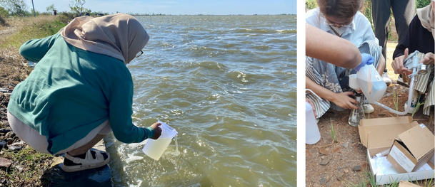
Module 1: Water quality assessment
This module began with a technical session to introduce the sampling and analytical procedures for surface water quality. Based on Professor Chow’s advice and supported by local project leaders, learners identified specific locations (a safe spot with access to a river) in their study areas for field work and collected water samples in the rainy season.
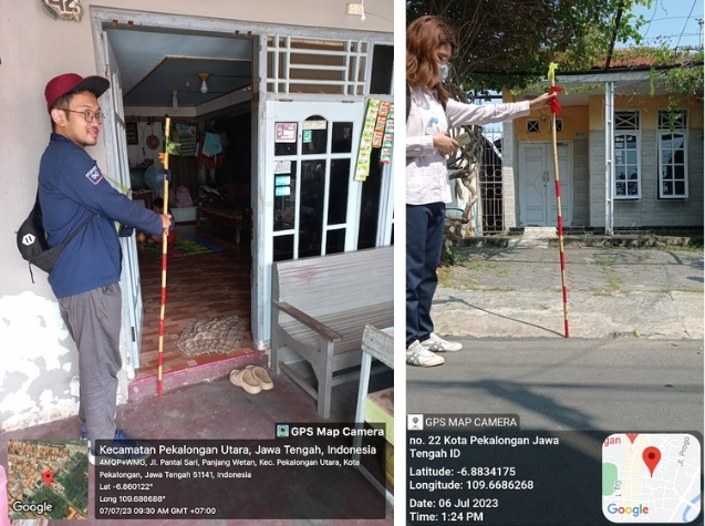
Module 2: Flood exposure assessment
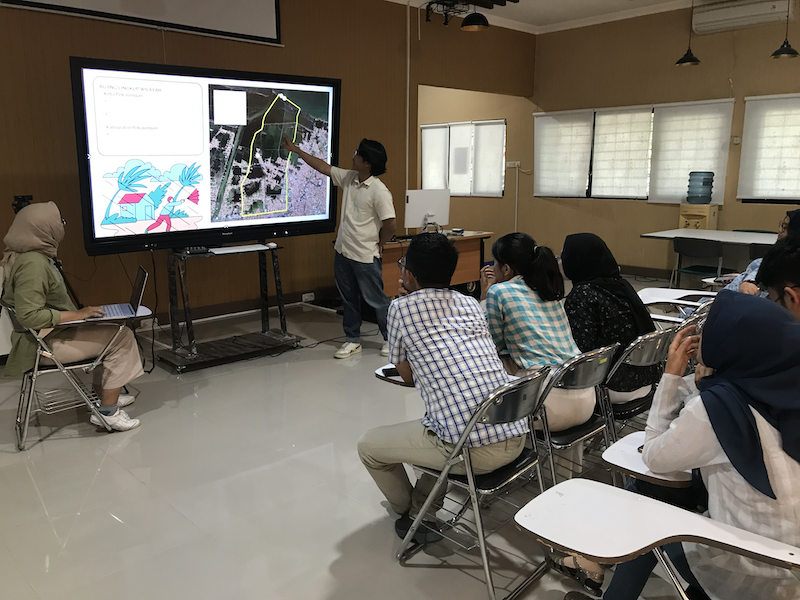
Learners identified an area in North Pekalongan and assessed its flood exposure using basic tools. They formulated a plan for data collection and identified and visited a previously flooded human settlement in the study area. In their field visits, they interviewed locals to obtain an oral history of previous flood events in the past two decades in that area and identified related information from historical floods (e.g., flood depth) and their impacts (e.g., economic losses of households, injuries and casualties, etc.) at specific locations. Upon identifying the ‘flood spots’, learners used a web-based map platform (e.g., Google Maps) to integrate this information into a digital map to determine the area flooded and, thereby, flood exposure of the site location.
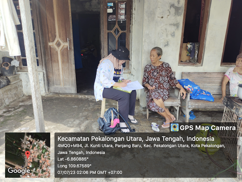
Module 3: Participatory vulnerability assessment
This module helped learners understand and use existing tools for vulnerability assessment and ways to implement participatory elements. Under guidance, learners formulated a plan for assessing the flooding sensitivity and the coping and adaptive capacities of the selected community in the study area. They also identified suitable and relevant indicators for vulnerability assessment and developed a participatory approach for gathering data. Learners, supported by local project leads, visited the community and conducted intensive field surveys, interviews, and focus group discussions to assess community vulnerability to flooding.
Module 4: Community-based risk reduction planning
This collaborative module involved a small research project. Learners gained problem-solving skills by developing a plan for reducing flood risks in their case-study community (e.g., a village). Under our guidance, learners were involved in defining the scope and methodology for this research, which aimed to review the local actions taken and policy and institutional support and identify opportunities and resources required for coping with and adapting to flooding (including pre-, during and post-flooding response). Six learners formed a group and prepared a final report.
Post-learning joint conference
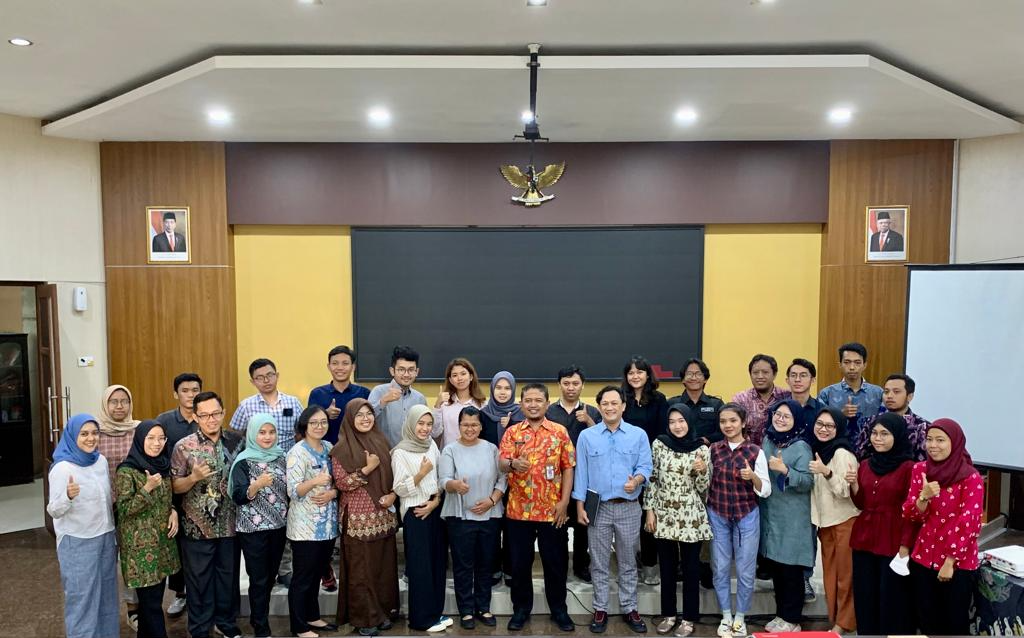
On 31st August 2023, learners presented their findings and final report in an online workshop. Learners shared their learning experiences with fellow learners as well as the PI and collaborators. Each learner who completed the programme and attended the joint conference was named a ‘DECAF Fellow’ and presented a certificate to recognise their participation in the programme.
3. PROJECT OUTCOMES
3.1. Activity highlights
Part I (online lecture series)
The DECAF received formal written support from the Central Java Province Government and the City Government of Pekalongan. In addition to student participation, the City Government of Pekalongan assigned 18 government officials whose scope of work is related to flood management to participate in phase 1. It shows that DECAF was highly relevant to the capacity development needs of the Indonesian local government.
A total of 228 Indonesian learners registered for the DECAF online lecture series. Most of them (>70%) did not previously receive any training in flood risk management and related field activities. An opening ceremony was held on the 2nd of May 2023, at Diponegoro University, Semarang, Indonesia. It was attended in person by approximately 80 students, the Dean of Engineering Faculty Universitas Diponegoro, the Head of Department of Urban and Regional Planning, the Head of Planning and Development Agency of Pekalongan City Government, and the representation of Agency for Water Resource and Spatial Planning of Central Java Province Government. Six weekly online lectures were conducted between May and June 2023. The online lectures attracted over 120 learners to attend via Zoom, including 18 local government officials from the Pekalongan City Government.
Part II (field activities)
Eighteen university students were trained in field activities in a coastal area of Pekalongan that is exposed to tidal flooding and sea level rise. These learners collected and analysed data about water quality (Figure 1), flood exposure (Figure 2) and community vulnerability (Figure 3). These included 183 onsite observations about flood exposure and 270 completed questionnaires about community vulnerability. They then came together to discuss possible strategies for helping communities to cope with flood risks (Figure 4). Field activities were completed in July 2023.
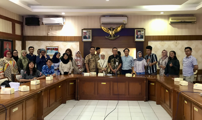
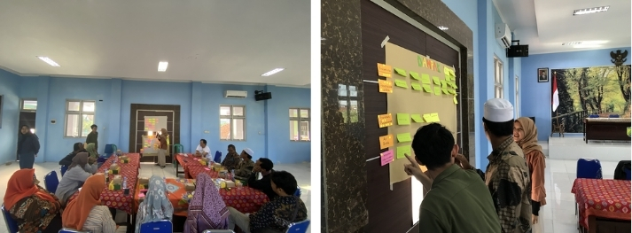
As part of the field activities, the learners had meetings with representatives of two relevant local government agencies in Pekalongan (Figures 5 and 6) and visited a climate adaptation pilot project site under the guidance of local NGO representatives. Learners also directly engaged in 3 separate focus group discussions that involved about 30 local community members, who represented small businesses, women, and youth, respectively (Figure 7).
3.2. Learners’ feedback
This session summarises the project evaluations completed by the eighteen learners, which were based on a list of structured and open-ended questions.
The majority of students expressed that the DECAF programme not only met but also surpassed their expectations. They valued the programme for its capacity to offer fresh perspectives, hands-on experience, and opportunities for teamwork. Notably, the programme’s emphasis on flood risk management, especially in relation to flood inundation and adaptation planning, received significant recognition. The fieldwork encompassed diverse modules conducted in groups, which proved highly effective in improving individual skills and teamwork capabilities. The firsthand experience of visiting flood-prone areas, engaging with the local community, and gaining knowledge about water testing left a profound impact.
Learners derived substantial value from the initial phases of the programme, encompassing group introductions, active engagement in activities, and the acquisition of knowledge. They also expressed gratitude for the opportunity to interact with local communities and gain firsthand insights. Many emphasised that the DECAF programme not only met their expectations but also broadened their perspectives, particularly concerning flood management systems, flood barriers, and social aspects. The DECAF programme earned praise for its co-design approach, which allowed participants to contribute to the planning and execution process. Furthermore, the support provided by practitioners and faculty members was commended for enhancing the overall programme experience.
In summary, learners felt that DECAF’s immersive experiences and practical knowledge equipped them with valuable tools to make effective contributions in their chosen fields, whether through research, policy-making, or community engagement. The programme was lauded for bridging the gap between theoretical knowledge and practical applications, ultimately enhancing their preparedness for future work. There was a sense of confidence that the knowledge acquired from DECAF, encompassing aspects like drainage systems, coastal infrastructure, and social considerations, would prove instrumental in their future endeavours, especially in fields such as urban planning and disaster management. The programme was regarded as a stepping stone toward developing critical thinking skills and adapting to real-world challenges.
Many learners highlighted that they had the opportunity to participate in the design and operation of the programme modules through the co-design approach. They were engaged in various aspects, including suggesting adjustments to the survey system, proposing modifications to the order of transects and clusters, and even combining certain modules for efficiency. Several of them mentioned that they played a role in selecting sampling locations, determining transect points, and adjusting the course of fieldwork to align with real-world conditions.
However, learners expressed that their input was not fully considered and indicated that they could have had a more substantial influence on the design and operation of the modules. Nevertheless, the prevailing sentiment was that the co-design concept was present, affording students the opportunity to shape the execution of the modules and tailor them to real-world scenarios. Learners valued the collaborative process and the chance to adapt the programme based on practical considerations.
Moreover, learners identified ways to further enhance the overall experience and outcomes of the project. They believed the programme was already comprehensive, covering various aspects of flood risk management, and felt it provided a sufficient understanding of the subject matter. Other suggestions included:
- Additional elements, such as conducting community awareness campaigns or providing training related to floods and water composition, should be included. This could involve sharing information about water quality after testing (Module 1).
- Time constraints were raised by multiple learners, particularly concerning Module 3. They expressed the need for more allocated time in certain modules to facilitate more in-depth activities, such as interviews and assessments.
- Communication with the local community could have been more extensive before field activities to assist in identifying suitable locations for surveys and tests.
- Suggestions for improvement encompassed better coordination, more intensive mentorship, clearer questionnaires for interviews, and a more effective strategy for distributing incentives to encourage community participation (Module 3).
- Providing direct feedback to the community regarding the survey results and policy proposals.
In addition, learners reported that their field experience led to a change in their perspective or differed from their initial expectations in the following ways. They were surprised by the extent of flooded houses, shorter building structures compared to road levels, and the transformation of the landscape due to embankments. Conditions in their assigned areas diverged from what they had anticipated, varying in the degree of impact from flooding. Others were taken aback by the prevalence of flooded homes. Some learners observed aspects that didn’t align with their expectations, particularly concerning the poor state of drainage systems in specific locations. They were often surprised by the physical and economic conditions in the affected areas, including older, less-maintained buildings. There was an expectation that more focus should be placed on structural solutions like embankments.
4. CONCLUSION
In conclusion, our project represented an innovative and collaborative initiative aimed at addressing the educational needs of senior tertiary students in Indonesia who were impacted by the disruptions caused by the pandemic. By focusing on flood risk management, we set out to equip these aspiring students with the knowledge and skills necessary to pursue careers in applied science and research, making them better prepared for the challenges of our ever-changing world.
Our unique approach, combining online learning, remote coaching, and local field activities, was tailored to create a more robust and adaptable digital training environment. This approach not only enhances the learners’ understanding but also fosters collaborative experiential learning, an invaluable asset for their future careers. The project was also successful in fostering North-South collaboration, bringing together expert educators from New Zealand, the United States, Hong Kong, and Indonesia. This collaboration enriched the educational experience, promoted cross-cultural understanding and ensured that the skills and knowledge gained would be readily applicable to the needs of Indonesia. Furthermore, the creation of digitally reusable resources underscores our commitment to the sustainability and long-term impact of this project, paving the way for future capacity development initiatives in the Global South.
5. ACKNOWLEDGEMENT
The DECAF project team appreciates Diponegoro University, (Indonesia) for providing logistic support to the programme activities. The team would like to express gratitude to the Planning and Development Agency of Pekalongan City Government, and the Agency for Water Resource and Spatial Planning of Central Java Province Government for providing institutional support and participating in some of the programme activities. Special thanks to the 18 passionate and energetic participants in Indonesia, and our local team members, including Faruq Al Muqsit and Mega Anggraeni. We also appreciate the Asia-Pacific Network for Global Change for funding this project under the Collaborative Regional Research Programme (CRRP) with grant number CBA2022-01SY-Lo.