
Comparing flood risk drivers and adaptation responses in Indonesia and the Philippines
Keywords
HIGHLIGHTS
- Presents two local flood risk case studies from Indonesia and the Philippines.
- Identifies livelihood vulnerabilities and creeping exposure as flood risk drivers.
- Discusses how local governments understand increasingly complex flood causes.
- Advocates for linking of hazards, vulnerability and exposure concepts.
1. INTRODUCTION
Flood impacts are escalating across regions worldwide, driven by increasingly complex local dynamics (Merz et al., 2021; Schoppa et al., 2024). While a growing body of research has provided quantitative models and projections for understanding potential future conditions (Nguyen et al., 2024; Shu et al., 2023; Zwirglmaier et al., 2024), there remains a significant gap in applying these findings to assess causes within local communities. Flood risk is often shaped by unique local factors such as land use, infrastructure quality and socioeconomic conditions. Understanding these linkages is important to connect disaster risk reduction, climate change adaptation and sustainable development efforts (Cabana et al., 2023; Kelman, 2017; Wijenayake et al., 2024).
Integrating resilience into urban development frameworks can reduce vulnerability, particularly in rapidly growing cities that often lack comprehensive flood preparedness (Osman, 2021). However, sustainable flood risk management requires urban development authorities to become well-versed in evolving flood risk patterns and drivers, such as urban expansion into flood-prone areas, to enhance local resilience (Cao et al., 2022). Top-down approaches to flood risk reduction often miss the mark on local needs and lived experiences, resulting in strategies that may be misaligned with community-level understandings and coping mechanisms (Silvis et al., 2024).
Increasingly, as flood risk intersects with socioeconomic and demographic pressures, traditional responses are proving inadequate (Aerts et al., 2024; Klijn et al., 2021). Yet, research that bridges social and environmental perspectives on adaptation and co-creates knowledge with communities remains limited (Miner et al., 2023; Nohrstedt et al., 2022; Sanders et al., 2024), leaving a critical need to interrogate local causes of flooding. This study seeks to address this gap by examining the drivers of shifting flood risk patterns in Indonesia and the Philippines and exploring how local communities and governments are adapting to these changes. We sought to answer two research questions:
- What are the drivers of shifting flood risk patterns in Indonesia and the Philippines?
- How are local governments adapting to changes in flood risk?
To answer these questions, we compare two in-depth case studies to examine evolving flood risk and the governance responses that are being mobilised. These cases offer a unique lens on how urban development, local governance and community actions intersect to shape flood resilience. Through examining these dynamics, we aim to contribute a more nuanced understanding of flood adaptation that moves beyond mono-centric problem identification to embrace locally specific, context-driven solutions.
2. METHODOLOGY
This study draws on a comparative case study (Yin, 2018) of flood risk in two localities – the Regency of Singkil in Indonesia and the Municipality of Carigara in the Philippines. An overview of the case locations is shown in Figure 1. The case selection was based on several criteria: (1) both sites experience escalating flood impacts driven by distinct local dynamics; (2) each location exhibits unique governance challenges; and (3) the community adaptation differs between the two contexts, providing valuable insights into varied responses to flooding risks. These factors make the two sites particularly suitable for a comparative analysis aimed at identifying transferable lessons for flood risk management. We first present an overview of the two cases, then provide an overview of flood modelling in both selected case sites, followed by qualitative data collected to understand how local governments are responding to manage flooding.
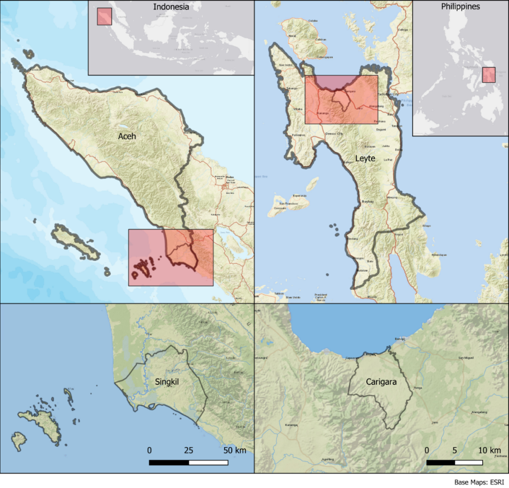
2.1. Case 1: Singkil, Indonesia
The Singkil Regency (Indonesia) is the southernmost regency in Aceh Province in Sumatra. The regency consists of two main areas – the mainland and neighbouring small islands. The central city is a relocated settlement situated around a coastal lagoon, while further inland to mountainous areas, is Gunung Leuser National Park. The capital city was moved after at least two tsunami events hit the coastal area in the mid and late 18th century. Singkil has a population of 126,514 (BPS, 2020). The Aceh earthquake and tsunami in 2004 and the Nias earthquake in 2005 caused significant loss of life and property, including damage to houses, schools, roads and other public infrastructure. Singkil experiences frequent flood events coming from one of the largest catchment areas (10,000 square kilometres) in Sumatra.
2.2. Case 2: Carigara, Philippines
The Municipality of Carigara (Philippines) is a coastal municipality in Leyte Province. Administratively, it has a total land area of 12,000 hectares and is composed of 49 barangays, the lowest administrative unit in the Philippines. The municipality has a total population of 54,656 and serves as the centre of trade and industry for neighbouring municipalities (Philippine Statistics Authority [PSA], 2020). Planning for and mitigating flood hazards has become a key priority for the local government due to the increasing damage brought on by typhoons, which regularly pass. Carigara has predominantly low-lying coastal settlements, which are particularly prone to the impacts of flooding.
2.3. Flood modelling, vulnerability profiling, and risk estimation
Digital elevation models (DEMs) were obtained from the Indonesian Geospatial Information Agency (BIG) 8-metre resolution National Digital Elevation Model for the Indonesian case site. For the Philippines study site, we used a combination of elevation data sources which included 2-metre resolution (2016) light detection and ranging data (LiDAR) from the University of the Philippines Disaster Risk and Exposure Assessment for Mitigation (DREAM) Project (DOST, 2016) and 6-metre resolution (2013) interferometric synthetic-aperture radar (IfSAR) from the National Mapping and Resource Information Authority. The research team also conducted a drone photogrammetry survey in 2022, which covered 4.6 km2 of coastal urban settlements (Opdyke & Besarra, 2024). Local field surveys were used to obtain bathymetry data for the middle and lower reach of the Lawe Alas River using a GNSS and echo sounder unit at selected cross-sections in Singkil. In Carigara, primary waterway channels were burned in post-processed DEMs in the absence of local bathymetric surveys. We also burned local urban drainage networks into the DEM for Carigara, using data from OpenStreetMap, which was collected in an earlier study (See et al., 2020).
Our analysis sought to unpack the root causes of flooding, including analysis of flood characteristics, flood return periods, and land use change, either natural or human induced. We used a hydrological and hydroengineering approach, employing GeoHECRAS and FLO-2D software in Singkil and Carigara, respectively, to develop 2-D flood models. The flood risk analysis consisted of first developing flood hazard assessments based on flood return period analysis, with rainfall data sourced from the Indonesian Meteorology, Climatology and Geophysics Agency (BMKG) and the Philippine Atmospheric, Geophysical and Astronomical Services Administration (PAGASA). For validation of our models, we compared simulated flood height with previous flood events at sampled survey points. Further details on the flood modelling approaches can be found in Alfian et al. (2023, 2024) and Besarra et al. (2025).
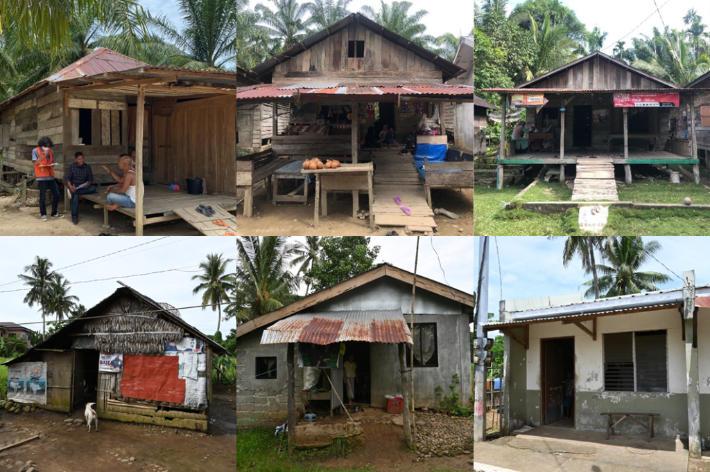
We then incorporated exposure and vulnerability to analyse flood risk for both sites. For Singkil, we collected 250 household surveys, which recorded flood inundation levels on buildings and captured socioeconomic flood losses. Examples of typical buildings surveyed are shown in Figure 2. We also used land use and land functionality zones to assess exposure. For Carigara, we similarly conducted 90 household surveys focused on flood impacts on buildings. For the Philippines data, these were further extended to flood fragility and vulnerability functions and used in combination with OpenStreetMap building footprints. Further details on how these were developed can be found in Besarra et al. (2024). Overlaying our flood layers with respective exposure and vulnerability data allowed us to examine impacts through total areas of settlements impacted for Singkil. It estimated the damage for Carigara using the linking vulnerability functions.
2.4. Interviews, focus groups, and serious games on flood risk governance
We also sought to understand how the selected local communities and governments are institutionalising disaster risk reduction knowledge in planning for flood impacts. We conducted key informant interviews (KIIs) and focus group discussions (FGDs) in both sites to understand how disaster risk information is currently utilised. Questions focused on unpacking why certain flood knowledge is given legitimacy, how knowledge of flooding flows among government and community stakeholders, and identifying knowledge barriers. Questions also covered the mechanisms of damage experienced and preparedness actions. KIIs and FGDs were conducted in the participants’ native language and then transcribed and translated for analysis. We analysed transcripts using NVivo qualitative analysis software to code for themes to profile knowledge adoption processes. An inductive approach was used to ground the subsequent themes in the cultural context of the respective sites. This resulted in a synthesised list of knowledge mobilisation strategies.
Lastly, we employed a participatory action research approach, using our flood risk models and the qualitative data to create a ‘serious game’ that was used to observe flood risk reduction decisions in a compressed simulation. Details of the game development can be found in Latham et al. (2024), and the game can be found in Opdyke et al. (2024). We used the game to create a space where participants enact behaviours, practice knowledge sharing (or not) and emulate increasingly uncertain flood risk contexts.
3. RESULTS AND DISCUSSION
We first discuss emerging environmental and climatic drivers of escalating flooding in both case sites. While these drivers are behind larger flood events, which have an increasing toll on local communities, their root causes stem from shifts in local livelihoods and settlement patterns. Finally, we discuss how local communities and governments are responding to these challenges.
3.1. Environmental and climatic drivers of flooding
Singkil and Carigara face heightened flooding that now appears more regularly, with higher intensity and longer durations. For example, one participant in Carigara stated, “Before, the rain wasn’t as heavy as it is now. Recently, there have been instances where the water reached the roads and even the agricultural areas, causing significant damage. The water takes about two to three weeks before it subsides.” Another participant stated, “During flooding, it takes days or even a week for it to subside.” Interview participants described observed shifts in seasonal patterns, including longer rainy seasons and more intense, localised storms. Similar accounts in Singkil point to increasingly irregular precipitation, further stressing communities.
In Singkil, the effects of the 2004 Indian Ocean earthquake and the subsequent Nias earthquake in 2005 further complicate flood risk. These seismic events caused significant land subsidence, leading to regular seawater inundation in low-lying areas. Singkil’s geographical location, coupled with the changes in its topography, makes it highly susceptible to tidal flooding from one of Sumatra’s largest catchment areas. Land subsidence has amplified coastal inundation, with protective coastal structures failing to keep pace with sinking ground levels. This phenomenon and gradual sea-level rise has caused Singkil’s coastline to experience frequent inundation, leaving homes and infrastructure increasingly exposed.
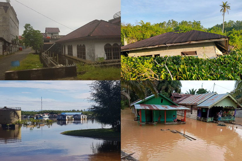
Furthermore, extensive peatland conversion for palm oil plantations has caused up to 1.23 metres of land subsidence, resulting in a ten-fold increase in flood inundation extents (Alfian et al., 2024). The substantial subsidence amplifies tidal flooding, turning what were once less common flood events into an annual occurrence. These impacts are shown in Figure 3.
Widespread deforestation and land conversion have significantly reduced river capacities at both sites. Local officials reported that upland deforestation contributes to sedimentation, which blocks canals and waterways, restricting water flow and worsening flood severity and duration. These environmental pressures – driven by both natural and human-induced changes – have reshaped flood characteristics.
3.2. Livelihood vulnerability and exposure encroachment causes of flooding
Across both cases, we see livelihood vulnerability and growing settlements as root causes of increasing flood risk. In Carigara, illegal logging practices have persisted despite local efforts to combat this practice. As previous literature has suggested (Pulhin & Dressler, 2009), illegal logging practices are rooted in complex local power dynamics, but often arise from poverty and limited alternative sustainable livelihoods. In the case of Singkil, the dependence on palm oil has been a major driver of the observed land subsidence. In both examples, livelihoods feature centrally, and both are causes behind increasingly severe flooding. However, we also see this circle back to impact vulnerable agricultural livelihoods, which are increasingly under pressure from extended flood inundation. Farmers described prolonged field inundation, reducing yields and limiting their income.
These economic pressures have weakened environmental governance, which is already stretched by restricted local government budgets. In Singkil, limited enforcement of environmental regulations, particularly around peatland conservation, has seen palm oil plantations continue to expand. These budgetary and governance constraints underscore the need for a coordinated, multi-level approach, including national and provincial support, to prioritise environmental governance measures for flood risk reduction. Local leaders described some guidance from national agencies advising on adjusting crop cycles for flood preparation, but larger livelihood investments are needed to break the observed sequence.
The second significant cause we observed stemmed from the continued encroachment of settlements into flood-prone land. This aligns with previous scholarship highlighting growing global flood exposure (Cao et al., 2022). Still, we observed that it was not just the location of this exposure, but how it is being constructed. The lack of urban drainage networks has not kept pace with settlement growth, which has led to growth surfaces that cannot shed flood waters. In Singkil, we observed this exacerbating fluvial flooding, while in Carigara, the impacts were more closely linked to worsening pluvial flooding.
In Singkil, dependence on oil palm cultivation has driven widespread peatland conversion, leading to severe land subsidence and heightened tidal flooding. This form of livelihood is capital-intensive, often tied to external investment, and has outpaced local regulatory capacity to manage environmental impacts. In contrast, livelihoods in Carigara are more subsistence-based, with illegal logging serving as a coping strategy in the absence of stable income sources. While both practices contribute to environmental degradation and flood risk, they stem from different economic logics – commercial expansion in Singkil versus livelihood survival in Carigara. These distinctions point to the need for differentiated policy responses: stronger environmental regulation and enforcement in Singkil, as well as livelihood diversification and support for sustainable resource use in Carigara.
3.3. Local flood adaptation responses
Local responses to flood risks in Carigara and Singkil reflect a mix of grassroots initiatives and infrastructural adaptations. In Carigara, community-based initiatives have led to coastal clean-ups, waste segregation programmes and flood preparedness activities spearheaded by the barangay councils and Sangguniang Kabataan (local youth councils). In some cases, we observed that households had started to take individual actions to protect their homes and raise floors above flood levels. While these initiatives represent proactive steps toward reducing flood impacts, their effect remains limited due to financial and logistical constraints relative to the scale of flood causes which have surfaced, highlighting the need for sustained investment and support.
In addition to actual adaptations, we also used the serious game we developed to explore how participants would make hypothetical decisions regarding future risk reduction measures. Across most participants, we observed a tendency to invest first in relatively low vulnerability assets to shore up their resilience to flood impacts. As a result, simulations often showed the loss of more vulnerable community assets to flood impacts. The vulnerability of assets was randomly assigned at the start of gameplay and was not inherent to an asset. As part of the scenarios, we intentionally varied the frequency and intensity of floods, but these were designed to become more likely and severe across rounds. This suggests a possible awareness gap among local actors in vulnerability reduction over hazard reduction as an approach to achieve risk reduction.
3.4. Insights for disaster risk reduction
Our findings challenge conventional hazard-focused approaches by highlighting their limitations in addressing the complex interplay of factors that contribute to flood risk. Traditional flood projects often concentrate solely on the hazard itself, such as the probability of flooding, while overlooking critical vulnerability and exposure elements, which can amplify or mitigate the impact of these events. By focusing narrowly on the hazard, these approaches endanger obscuring deeper systemic issues, failing to account for how social, economic and environmental factors intersect to create risk. This narrow view can lead to reactive rather than preventative interventions, ultimately providing only partial protection against future flood events.
By a “systems approach,” we refer to the integration of hazard, exposure and vulnerability analysis across multiple levels of governance, ensuring that local observations inform regional and national disaster risk strategies. This approach requires moving beyond single-dimensional hazard models to recognise how social, economic and institutional factors interact to shape risk. In our study, for example, the drivers of land subsidence in Singkil are rooted in regional livelihood incentives and weak enforcement of environmental policy. At the same time, flood risks in Carigara are influenced by upland deforestation linked to limited income-generating alternatives. These examples illustrate how fragmented or overly technical interventions fail to capture the systemic nature of flood vulnerability, reinforcing the need for cross-scalar, context-specific responses.
There is an urgent need to scale systems approaches that capture the linkages between hazards, vulnerability and exposure within disaster risk assessments. Without this broader view, we miss the root causes of flood risk that are often embedded in social inequalities, economic policies and land-use practices. By examining how these dimensions are interrelated, disaster risk assessments can more accurately identify which factors exacerbate risk and which interventions are suited to reduce it.
3.5. Limitations
This study has several limitations, notably the relatively modest sample sizes of household surveys, potentially limiting the generalisability of some findings. Additionally, data availability, especially detailed socioeconomic data and high-resolution hydrological information, varied between the two sites, affecting the precision of particular vulnerability and risk assessments. Future studies could benefit from larger sample sizes and enhanced data resolution to strengthen comparative insights.
4. CONCLUSION
In summary, this study has brought to light the multifaceted drivers of flood risk in Singkil, Indonesia and Carigara, Philippines, underscoring how environmental, climatic and socioeconomic pressures intersect to exacerbate flood impacts. Our findings illustrate that flooding in these regions is deeply rooted in livelihood vulnerabilities and growing exposure, building on strong theoretical framings in disaster scholarship (Blaikie et al., 2014). Our findings reinforce the need to capture better the linkages between hazards, vulnerability and exposure, building on recent scholarship and adding context-specific evidence of how these linkages play out at local scales. Our results draw attention to the importance of the specific drivers identified in the two cases as possible areas of attention for national governments. Our findings also reinforce the need to see disaster risk reduction as an endeavour that involves more than tackling natural hazards.
Future research should continue to prioritise localised flood vulnerability assessments to explore how unique socioeconomic and cultural factors influence flood risk. Such studies could inform more nuanced, tailored interventions that enhance adaptive capacities at both the community and policy levels. By embracing these comprehensive approaches, policymakers can address the root causes of flood risk and contribute to sustainable, resilient futures for communities across flood-prone regions.
5. ACKNOWLEDGEMENT
This research was funded by the Asia-Pacific Network for Global Change Research (CRRP2021-13MY-Opdyke) with additional support from a Humanitarian Engineering Scholarship from the University of Sydney (SC404076).