Village mobility and local resource utilisation are adaptation strategies in Nepal’s Koshi Floodplain
Keywords
Community wisdom · Coping strategy · Disaster risk management · Disaster risk reduction · Local and traditional knowledge
HIGHLIGHTS
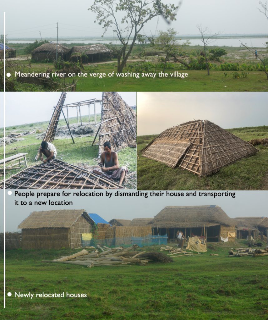
- Village mobility in response to the shifting river is a key adaptation strategy.
- Village mobility relies on local house designs that can be dismantled, transported and reassembled.
- Local institutional systems reinforce disaster risk adaptation strategies.
- Integrating local knowledge into local disaster management plans is crucial for effective adaptation.
1. INTRODUCTION
Rivers are complex, multi-attribute, and multifunctional systems that have contributed to human civilisation since ancient times by providing various direct and indirect services (Wang & He, 2022; Algaze, 2008). For example, the Nile in Egypt (Algaze, 2008), the Yangtze in China (Macklin & Lewin, 2015), and the Indus in Pakistan and India (Wheeler, 1968) provided important avenues for the growth and evolution of societies. Now, about half of the world’s population lives within 200 kilometres of coastlines and major rivers, and this number is projected to double by 2025 (Creel, 2003). The benefits of living near rivers and coastal zones are manifold, ranging from economic opportunities to cultural ties (Fang & Jawitz, 2019; Yevjevich, 1992). River floodplains and riverbanks are agricultural repositories as floodwaters deposit nutrient-rich organic sediments in such areas (Carpenter-Bundhoo et al., 2020; Prideaux and Cooper, 2009; Singh et al., 2021). Rivers serve as habitats for a wide range of aquatic and terrestrial species and render several ecosystem services (Boulton et al., 2016). They hold culturally significant value, including recreation and social interaction (Wang & He, 2022; Wiyanarti, 2018). They also facilitate transportation, trade, and commerce (Samah et al., 2011; Morozova, 2005). Rivers, therefore, have been a venue of cultural exchange, facilitating the spread of knowledge and ideas (Anderson et al., 2019). Some river floodplains experience frequent and intense natural hazards, including floods, sediment deposition, and river channel shifts. Local communities living in such areas have developed knowledge in terms of human and social capital to cope with disasters (Aldrich et al., 2018). It is therefore important to identify ecological and social circumstances to understand and reinforce effective strategies to cope with various types of disasters (Mercer et al., 2012; Tran et al., 2009).
From a socio-hydrological perspective, rivers and society intertwine through continuous interactions across space and time, shaped by river floodplain morphologies, floodwater dynamics and the ecological services the river provides (Wantzen et al., 2016). Communities living in disaster-prone areas typically have socio-ecological systems that sustain themselves on local resources (Ferrol-Schulte et al., 2013; Huber-Sannwald et al., 2012). Such systems constitute traditional and local knowledge (TLK) (e.g., know-how, skills, and practices) that are often embedded in social and cultural practices developed, sustained, and passed on from generation to generation (Ford et al., 2020; Nakashima et al., 2012). TLK is dynamic, continuously evolving through interaction with new information and challenges (Sillitoe, 1998).
However, the use of local resources alone—especially when driven by economic scarcity—does not necessarily indicate the presence of TLK. In such cases, reliance on local materials may reflect socioeconomic vulnerability rather than intentional, knowledge-based adaptation strategies. Therefore, it is crucial to document TLK as a location-specific, context-dependent knowledge system rooted in empirical observation and practical experience (Berkes, 2018; Huntington, 2000; Sillitoe, 1998), to ensure accurate recognition and appropriate application in resilience and development planning. For example, local communities enhance their resilience to disasters by effectively using local resources in a given time and place (Ferrol-Schulte et al., 2013) and by adopting site-specific housing and settlement practices (Vojinović, 2015; Vojinović & Abbott, 2012).
Exploring such knowledge and its documentation is integral to understanding the interplay between culture, environment, and natural resources (Nakashima et al., 2012; Oliveira, 2012; Tauli-Corpuz et al., 2020), and can be valuable for identifying innovative and sustainable approaches to coping with disaster (Kniveton et al., 2015; Makondo & Thomas, 2018; McWilliam et al., 2020; Peters-Guarin et al., 2012; Petzold et al., 2020).
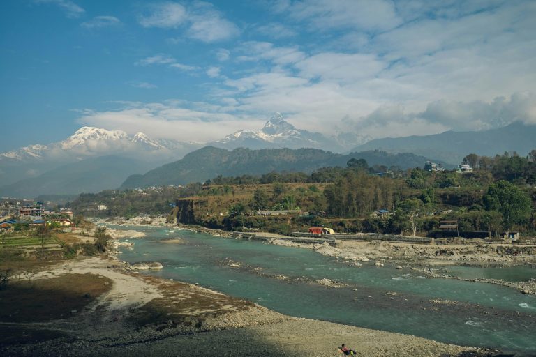
Nepal has an extensive network of rivers, organised into four major river systems that drain into the Ganges River in India. In mountainous areas of Nepal with steep slopes, rivers flow along narrow channels, and flat riverbanks in lowland Nepal are few due to shorter distances within the country, but they are highly productive agriculturally. The flat lowland areas are short, where rivers meander across a wide area in several channels. Despite being susceptible to floods and erosion, such floodplains were attractive destinations for migrants from the mountains due to their high agricultural productivity and opportunities for animal husbandry. The Koshi River floodplain, stretching from south of Chatara to the Nepal-India border, is one example. These areas gradually became less attractive as agricultural infrastructure expanded in other areas. Most areas are abandoned, except in a few locations where a few traditional communities still live in the vast river floodplains. The Koshi River is known for frequent floods and river channel shifts (Sinha et al., 2019), causing extensive damage to crops, livestock, and infrastructure and displacing thousands of people.
This study focuses on two representative village clusters in the Koshi River floodplain of Nepal to explore the disaster risk adaptation strategies employed by local communities. These villages are highly flood-prone (Kafle et al., 2017) and have been repeatedly relocated in response to the river’s shifting course (Candau, 2020b). Adaptation strategies in such contexts are typically based on site-specific knowledge for predicting and forecasting risks, the utilisation of local resources to enhance resilience, and the establishment of institutional arrangements to govern both resources and knowledge (Ferrol-Schulte et al., 2013; Vojinović, 2015; Vojinović & Abbott, 2012).
Within this framework, the study specifically addresses the following research questions:
- What site-specific housing and settlement practices have been developed to cope with the meandering course of the Koshi River?
- In what ways are local resources utilised to maximise resilience against flood-induced risks?
- What institutional mechanisms exist at the community level to govern knowledge and practices related to disaster risk adaptation?
2. METHODOLOGY
2.1. Koshi River Basin
The Koshi River Basin (KRB) covers nearly 30,000 km2 of land from the Himalayas to the Terai Plains and is shared by China, India, and Nepal (Wahid et al., 2017). The Koshi River originates on the Tibetan plateau, flows through eastern Nepal and northern Bihar, and joins the Ganges. In Nepal, the river consists of seven major tributaries—Sun Koshi, Indrawati, Dudh Koshi, Tama Koshi, Likhu, Arun, and Tamor—all originating from the Himalayas. The Koshi River is known for its high discharge with an average discharge of 2,166 cubic meters per second (m3/s), which peaks during the monsoon season (June to September) and reaches up to 70,000 m3/s. This makes the Koshi River one of the largest rivers in terms of water flow in South Asia (Sinha et al., 2019). It is also known as the world’s highest silt-producing river (Sinha et al., 2019), and flood and sedimentation are common in its vicinity (Mishra & Sinha, 2020; Wahid et al., 2017).
The KRB encompasses diverse climatic regimes, ranging from tropical in the south to alpine zones in the north (Agarwal et al., 2014). Data shows a significant warming trend in KRB, with temperatures rising between 0.3 °C and 0.6 °C per decade (Vaidya et al., 2022). The region is recognised as a global biodiversity hotspot for exceptionally rich ecosystems, including many globally endangered and endemic flora and fauna (Mittermeier et al., 2004; Myers et al., 2000).
Hydrologically, the basin is primarily rain-fed during the monsoon and sustained by snow and glacier melt during spring and summer. Between 1980 and 2010, the glaciated area in the basin declined by 26% (396 km2) (Bajracharya et al., 2014). The region is increasingly vulnerable to multiple hazards—including glacial lake outburst floods (GLOFs), landslide lake outburst floods (LLOFs), landslides, flash floods, riverine floods, debris flows, and droughts—many of which occur in cascading sequences (Vaidya et al., 2022). Climate change-induced events (e.g., extreme precipitation) are expected to intensify both the frequency and magnitude of these hazards (Agarwal et al., 2014). In 1954, the governments of Nepal and India signed the Koshi Agreement that allowed the Indian Government to construct a barrage and a 150 km-long embankment (Agarwal et al., 2014). While the dam has been successful in controlling floods in India and erosion on the eastern part of the river in Nepal, people living in the downstream and western part of the river remain unsatisfied due to the perceived risks of flood, and differentiated priorities between the Nepali and Indian governments (Dixit et al., 2009).
The dynamics of the Koshi River Basin are now shaped by a complex interplay of topography, land use and land cover (LULC), water infrastructure, ecosystem services, socioeconomic conditions, governance structures, and policy priorities, indicating that the basin’s hydrological regime alone does not fully capture its characteristics.
2.2. Socio-fluvial and historical context of the Koshi River
The Koshi River was once known as “The Sorrow of Bihar” during British India because of frequent floods and the problems they caused. This term reflects the perception of the Koshi as a source of destruction and misery rather than a valuable resource supporting the livelihoods of millions living in its basin. Consequently, priority was given to engineering-based flood-control interventions. From 1891 to 1947, numerous proposals to build embankments and high dams were made, but no consensus was reached. After India gained independence from Britain, North Bihar experienced a devastating flood that demanded urgent action. On April 25, 1954, Nepal and India signed the Koshi Agreement amid strong criticism from both sides (e.g., India—engineering solutions without fully understanding the river’s nature; Nepal—sharing of water and riverine resources and sovereignty rights on land use) (Dixit et al., 2021). Experts such as hydrologists, geologists, hydraulic engineers, and local leaders also criticised the appropriateness of embankments and barrages for long-term flood control. However, the construction proceeded as proposed, driven by the dominant political interests of the time.
The Koshi Project’s flood control infrastructure has shown to be ineffective. The Koshi embankments have been breached eight times since construction, including a major breach in 2008 that marked the failure of conventional flood control methods (Dixit, 2009). Since construction began, people living in the river basin have remained unsatisfied. Resentment started at the onset of barrage construction due to limited compensation and relocation options. The barrage led to the inundation of agricultural land, forests, and cultural sites, resulting in the involuntary displacement of segments of the population. In many areas, water scarcity in the dry season has increased, and the reduced river flow downstream of the barrage has significantly impacted both human and ecological communities. The slow-moving rivers deposited silt and sand (rather than washing it away), leading to floods with little rain as compared to before the barrage was constructed (Mishra, 2008). Traditional farming systems supported by community-managed small-scale irrigation collapsed, forcing local people to rely on bureaucrats and technocrats living far away (Dixit et al., 2021). The transformation of the Koshi floodplains from a fertile and dynamic socio-ecological landscape into largely unproductive land—either silted or waterlogged—largely stems from a technological, bureaucratic and top-down approach that prioritises water for irrigation and hydroelectricity while failing to recognise the value of ecosystems and the social systems that sustain distinctive livelihood opportunities (Siddiqui, 2021). The floodplains that are either water-deficient or permanently waterlogged forced many to abandon their traditional occupations and cultural ties to the land (Mishra, 2008). The resentment is intensifying due to frequent embankment failures and the rising risk of total collapse of the barrage during major flood events (Mishra, 2008).
Thus, the barrage’s impacts extend beyond hydrology, and they have reconfigured land ownership, traditional occupations, and marginalisation. The dynamic floodplains were historically intensively utilised for agriculture and animal husbandry, providing livelihoods that were both productive and resilient. Currently, much of the area is characterised by alternating dry and waterlogged conditions. Flooding in downstream areas has become increasingly unpredictable, while risks remain high due to recurrent dam failures (Dixit et al., 2021; Mishra, 2008; Siddiqui, 2021). It is important to note that the Koshi River has shifted laterally about 113 km westward in the last 250 years (Chakraborty et al., 2010). There is growing concern that the Koshi could soon abandon its current course, triggering a new cycle of destruction. There are increasing calls to adopt a holistic approach for the development of the Koshi River Basin by engaging stakeholders in dialogue across disciplinary, political, and geographical boundaries (Dixit et al., 2021; Mishra, 2008; Siddiqui, 2021). This study aims to understand one dynamic interaction between local communities and the river ecosystem.
2.3. Study area
The study area is situated in the southeastern part of Nepal along the confluence of the Koshi River. It covers Gariya Tappu and Gobargada villages (Figure 1). Gariya Tappu is a small village located along the western bank of the Koshi River, Nepal. The village becomes an island (locally called “Tappu”) during the monsoon season, when a small tributary on its northern side expands into an impassable river (Candau, 2020a). The village frequently experiences flooding (Kafle et al., 2017) and has shifted location several times in response to the river’s westward migration (Candau, 2020b). The village has a total population of 6,714, comprising diverse communities with distinct languages and cultures (Candau, 2020a), and is well known for its high agricultural production.
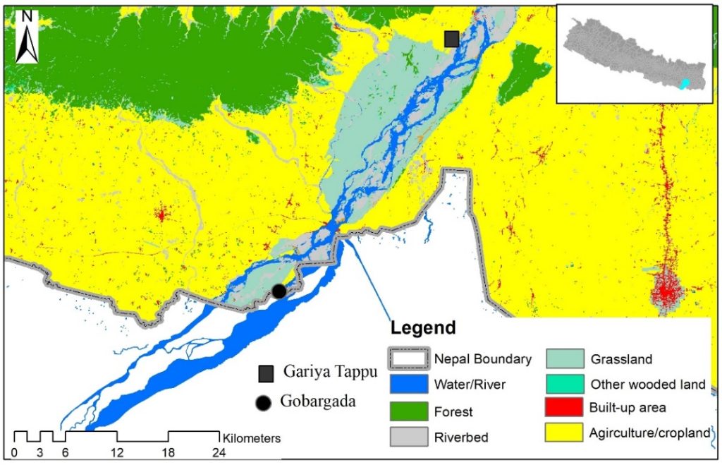
Gobargada is a small village located in the Saptari district of the Madesh province in Nepal, close to the Indian border (Figure 1). This village lies between two large branches of the Koshi River, making it remote and inaccessible throughout the year. The village had a total population of 700 individuals (144 households) as of 2020, a sharp decline from 1,791 individuals in the 2011 national census (CBS 2021). The majority of them belong to the Yadav ethnic group, who are known for keeping livestock. The vast floodplain landscape surrounding the village is exploited as a pasture (Wahid et al., 2017). Other ethnic communities include Malahaa (known for fishing) and the Musahar (known for rat hunting) (Candau, 2020a). Animal husbandry for milk production is the main source of income for the majority of people in Gobargada, especially among the Yadav community. Some people work as labourers in nearby markets for their livelihoods. This is common among marginalised communities (Candau, 2020a).
2.4. Data collection and analysis
2.4.1. Questionnaire Survey
We conducted a questionnaire-based household survey covering 50% of households in the Gariya Tappu and Gobargada cluster (Figure 1). The Gobargada cluster includes Gobargada and Chatauni villages. Due to a clustered pattern of human settlements, we first divided houses into clusters, selected the first house at random, and proceeded with the survey in every alternate household. In cases where the selected house was empty or the respondent declined participation, we selected an adjacent household. Before each survey, we introduced ourselves and explained the purpose and nature of our study. We also clarified that the data would remain anonymous and obtained verbal informed consent. All surveys were recorded using a sound recorder.
A total of 164 household surveys (HHs) were conducted in these two villages in 2022 and 2023. The questionnaire included items on respondents’ general characteristics (e.g., age, ethnicity, and living in this area), sources and durability of building materials, and activities undertaken to prepare for, prevent, mitigate, or respond to flood-related hazards, including frequency and location of household shifts in the last 60 years.
Our survey was conducted in an informal, conversational setting to foster trust and ease among respondents. This approach involved initiating informal conversations with respondents, addressing them as “uncle,” “aunt,” “brother,” or “sister” in the local language, and discussing family matters. Such culturally embedded exchanges are generally well-received in rural areas of Nepal and help to create a comfortable environment. Moreover, the interviewer refrained from using questionnaires or other formal documents in order to avoid giving respondents the impression that they were being scrutinised or interrogated. The central aim of this strategy was therefore to foster an atmosphere of open discussion and sharing, rather than a conventional interview setting. The survey team included three members: one fluent in the local language who led the conversation, a second who managed audio recordings and a third who took field notes when necessary. The surveys were administered to household heads, but sufficient time and opportunity were provided for other family members to participate in the discussion. The survey was administered using an object-oriented survey approach, eliciting responses anchored in tangible household objects, practices, or settings (Woodward, 2007; Pink, 2004). For example, when discussing preparedness, respondents described where important documents are kept, how food and fuel are stored, and which structures are reinforced during the monsoon season. This approach allowed the team to gather context-rich, material-based data on local adaptation and risk management behaviours (Chambers, 1994; Ellis, 2000).
In addition to structured surveys, we employed participatory field observation to further explore community disaster risk reduction practices. Immediately after completing the survey, respondents were invited for a joint walkthrough of their house and surroundings. During this walkthrough, we applied ethnographic techniques—such as discussions highlighting observed materials and practices, observational note-taking, and spontaneous elicitation—to explore respondents’ personal experiences, adaptation, and coping strategies (Desai & Potter, 2006; Pink, 2012).
As part of this walkthrough, one of our team members conducted a visual estimation of local material use in household structures such as homes, cowsheds and storage units. This was done using a transparent 20 × 20 cm2 grid sheet, with each cell measuring 1 × 1 cm2. The sheet was held approximately 0.5 m away from the eye and placed parallel to the target surface, allowing for a visual estimate of the area covered by various building materials. This object-based participatory method enabled us to quantify the relative proportion of local versus non-local materials used in construction. This method was especially valuable as material and resource use—particularly the use of locally available resources—has been identified as a key household-level adaptation strategy in resource-scarce and hazard-prone environments (Adger, 2000; Agrawal, 2010).
Data collected from the household survey and participatory field observation were documented through audio recordings and detailed notes. These recordings were carefully reviewed and transcribed by two researchers, with particular attention to identifying key adaptation strategies. Subsequently, major patterns emerging from the notes and transcriptions were systematically grouped and triangulated to identify the primary strategies employed for disaster risk reduction. To determine whether the proportions of different local materials used in surveyed households were significantly different, a Chi-square Goodness-of-Fit Test was applied. Household shifts were estimated based on the number of relocations and corresponding years. The data was used to compute the average number of shifts, and the major relocation patterns were graphically visualised by overlaying locations and directions on Google Earth images.
3. RESULTS
The Koshi floodplains routinely experience floods, mostly in June, July and August. The susceptibility to flooding is influenced by the extent and duration of rainfall in the upstream areas. The entire village of Gobargada is often inundated once or twice a year, with flood depths ranging from a few inches to several feet. Such flooding events mostly last a few hours, although in extreme cases they may persist for one or two days. Floodwaters typically recede rapidly due to the sandy, porous soil of the river floodplains. In anticipation of such floods, items vulnerable to water damage, such as food, cloth, firewood and dry fodder, are stored at elevated locations within the house.
Flooding in Gariya Tappu is occasional, but during the monsoon, heavy rain can swell small rivulets into large channels, and for a short while, the region becomes an island. Such occurrences typically last between a few days to a few hours, depending on the intensity of upstream rainfall.
Three critical aspects of community responses to flood hazards were identified from the data: (1) village mobility relative to the meandering Koshi River, (2) utilisation of local resources and knowledge, and (3) informal institutions to prepare for and respond to the flood-induced hazards.
3.1. Village shifting to the meandering Koshi River
Village shifting is a common phenomenon in Gariya Tappu, Chatauni, and Gobargada villages. Over the past 60 years, two major shifts were recorded in Gariya Tappu, three in Chatauni and four in Gobargada (Figure 2). Chatauni, in particular, shifted several times over short distances of approximately 100 m (Figure 2). Village shifting is a gradual process, with houses located closest to the river relocating first in response to the rate of riverbank erosion. The complete relocation of a village may take from a few weeks to several years. For example, there were high relocation rates between 1981 and 1989, between 2011 and 2013, and between 2021 and 2023.
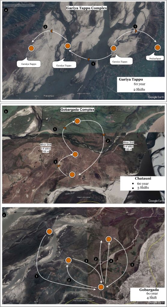
The relocation site shows a pattern of repetition in the Gobargada complex, where shifting occurs to previously abandoned areas when the river changes its course (Figure 2b,c). At the household level, the average number of household shifts in the Gariya Tappu cluster over the last 60 years was 2.44, corresponding to an annual average of 0.056, with substantial variability across households (±0.23). In Gobargada, the average number of household shifts was 2, with an annual average of 0.68 (±1.5), indicating a significantly higher number than that of the Gariya Tappu cluster.
3.2. Almost all of the construction materials come from locally available resources
The human settlements in the study area were typical of the region, comprising three or four types of physical structure in each household, including a house, a storehouse/kitchen, a praying house (in a few cases), and a buffalo shed. A total of seven different items were used in the construction, of which almost all were locally sourced, accounting for 99% in terms of area and 96% in terms of frequency of use.
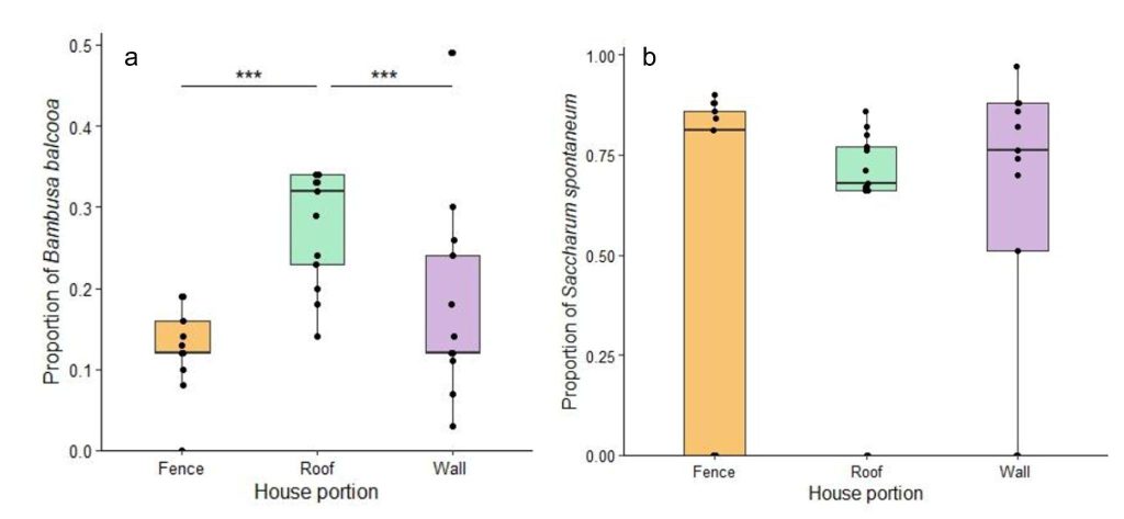
Khar (Saccharum spontaneum) was widely used: up to 85% in fences, between 65–80% in roofs, and between 50–90% in walls (Figure 3b). There were no significant differences in the proportion of Khar used across different household components (Figure 3b). Pater (Typha elephantina) was predominantly used in the inner walls of houses. Bamboo (Bambuseae sp.) constituted 12–18% of fencing, 22–35% of roofing, and 15–25% of walls, showing a significantly higher proportion of use in roofing compared to fences and walls (χ2 = 16.001, df = 2, P < 0.001; Figure 3a).
In terms of frequency of use (i.e., the number of times a material was used, regardless of volume or area), the most frequently used materials in local construction were bamboo (Bambuseae sp.) (32%), Khar (28%), Pater (19%), wooden logs (13%), Narket (Phragmites karka) (4%), steel (4%) and Jhauwa (Tamarix dioica) (1%). Overall, in terms of the proportion of materials used, Khar comprised nearly 64% of construction materials, followed by bamboo (20%), Pater (13%) and Jhauwa (2%), with local materials accounting for 99% by volume.
3.3. Local institutions and governance as key to community adaptation
Local institutions and leaders, play a crucial role in various aspects of disaster risk management. In Gobargada, the community employs customary techniques to assess the likelihood of flooding by closely monitoring the attributes of the adjacent river. We noted “no plans of relocation” in several houses that were too close (∼100 m) to a large but meandering Koshi River in Chatauni. One participant elaborated,
“You might be surprised to see our house too close to the river. We have been here for the last 3 years. The river is wide and its main current is not directed toward the village side. It will deposit sand on our side and we are confident about our safety from our experience”.
Relocation decisions are made by informal local institutions composed primarily of elders and experienced community members. Though not in an organised hierarchical order, leadership belongs to those with the most experience and seniority, who thereby exert greater influence on decision-making within the group. Such informal governance bodies follow a participatory approach where everyone can participate in the discussion during routine community gatherings (e.g., leisure time during morning/evening at the riverbank) about different aspects of the river, such as flow rate, water depth, the quantity and nature of river channels, and erosion and deposition trends. An elderly resident of Gobargada described,
“We are always vigilant about the river and observe it closely during our daily work. Information about any changes—such as shifts in the current, erosion, or sedimentation—is constantly gathered and shared among community members. We assess the level of risk and discuss when and where we should move. Our decisions also include the allocation of plots within the proposed relocation area and the orientation of the new settlement.”
4. DISCUSSION
Living in floodplain areas for centuries has been made possible through the adoption of strategies tailored to socioeconomic circumstances and types of disasters. Many of these ex-ante and ex-post coping strategies evolve through a gradual but sequential ‘learning by doing’ (Roberts et al., 2012). The use of local resources and technology is a key feature of such adaptation measures (El-Masri & Tipple, 2002). These measures rely on ecosystem services that are locally available, affordable, and easily generated and developed using local skills and practices (Paudel et al., 2023).
Flooding brings nutrient-rich sediments that enhance soil fertility and support productive agriculture and animal husbandry. Consequently, local communities value the livelihood opportunity associated with the floodplain. The challenges posed by rivers are often addressed by unique adaptive strategies: houses are relocated in response to the meandering/shifting river gradually, where homes are built to be repairable, portable and easily relocated. Specifically, the roofs and walls are constructed in such a way that they can be easily disassembled into portable pieces by a few individuals, if necessary. Although local materials have a short lifespan of 1–5 years due to exposure to the sun and water, broken or damaged parts are replaced with new materials. As a result, relocated houses are made from the components of previous buildings.
Additionally, there is a resource maximisation strategy when using local resources in construction. For example, cattail, unlike Khar, is widely used as a construction material for fences, though it quickly breaks down when exposed to water and sunlight. The use of abundant resources, such as cattail, indicates resource maximisation, with other resources (e.g., Khar) reserved for applications where their strength and durability are more crucial. These practices, rooted in tradition and local knowledge, are highly contextual (Clapham, 2002) and evolve in response to local resources for both preventive and mitigative initiatives (Paul & Routray, 2010; Thompson & Tod, 1998). Such strategies reduce dependence on external aid, lower costs, and strengthen resilience (Nakashima et al., 2012).
The Koshi floodplain is not only a dynamic landscape shaped by the meandering and shifting river but also a deeply embedded socio-cultural and economic system that sustains rural communities (Vaidya et al., 2022). Although often perceived by technocrats as merely only a flood-prone zone, the Koshi riverscape provides a wide range of vital ecosystem services that support livelihoods, including agriculture, fishing, and livestock rearing (Siddiqui, 2021). While floods pose threats to life and property, local communities do not view the river solely through the lens of risk. Instead, they recognise its dual nature as both a source of destruction and a foundation for sustaining livelihoods (Dixit et al., 2021; Mishra, 2008). Risk perception is not uniform. For some, they view it as an inevitable aspect of living with the river. For others, cultural values and economic conditions more strongly influence how risk is understood and responded to (Douglas & Wildavsky, 1982; Gierlach et al., 2010).
Two challenging views exist in the literature concerning the use of local resources. First, local resources are cheap, easily accessible, and mostly abundant, and their use makes local communities self-reliant and independent. Here, the access to and availability of local resources commonly used in these villages have a big impact. For example, khar and narkat are abundant, just a few meters away from human settlements. Khar alone accounted for more than 60% of the total construction materials. This is consistent with several findings indicating a positive relationship between the use of local resources and the cost-effectiveness of adaptation measures (Nunn & Kumar, 2024; Paudel et al., 2023). A competing viewpoint, emphasising resource durability, posits that less durable materials lead to greater reliance on resources, which can cause overharvesting and gradually diminish the resource base (Janssen & Scheffer, 2004). This assumption might be valid where resources are scarcer.
Religious and social institutions, including local leaders, play a crucial role in various aspects of disaster risk management (Shaw & Izumi, 2014). Such organisations have a deep understanding of the local context and are well positioned to plan and implement appropriate responses to disaster risk reduction (Dewan, 2015). Thus, a near-complete reliance on local resources for housing materials and on unique local construction skills, along with swift relocation practices, make the coping mechanism a regular, culturally embedded tradition (Figure 4).
5. CONCLUSIONS
The people of Gariya Tappu and Gobargada villages have developed their coping mechanisms through experience and their intergenerational transfer. With the construction of barrages and embankments, many traditional communities have been facing water scarcity, drought and frequent floods, which have disrupted traditional socioecological systems. However, these two villages have remained notable exceptions. The site-specific adaptation strategies documented in this study should be incorporated into local development plans, yet they are often overlooked. This has resulted in significant damage to public resources. For example, in Gobargada, while local residents use easily repairable materials for housing, permanent government infrastructure, such as schools, is frequently destroyed by river channel shifts—indicating a lack of consideration for the local context. It is therefore important to recognise and prioritise such local knowledge in development planning and disaster risk reduction. There is an urgent need to adopt a holistic approach to the development of the Koshi River Basin by fostering stakeholder dialogue when planning large water-related infrastructure.
6. ACKNOWLEDGEMENTS
The authors would like to acknowledge the Asia-Pacific Network for Global Change Research Collaborative Regional Research Programme (CRRP2021-04MY-Paudel) for funding this study under the project, “Enhancing ecosystem-based adaptation to disaster risk reduction in the Himalayan River basin: Integrating traditional and local knowledge in disaster management plan in Nepal, India and Bangladesh”. The authors would also like to thank local communities and project staff (Arjun Lamichanne, Meena Bohora and Sailendra Sharma) for their contribution.