CAF2015-RR19-NSY-Monprapussorn
Integrated analysis of climate, land use and water for resilience urban megacities: A case study of Thailand and Viet Nam
Keywords
Bangkok · Climate change · Hanoi · Land use · Water resources
Highlights
- Projection of climate change by 2050 in two urban megacities in Southeast Asia.
- Scenario-based method for land-use prediction by 2050 based on driving forces.
- Water demand analysis considering socio-economic change.
1. Introduction
Water is a crucial resource for human survival in Southeast Asia. More than five billion people could suffer water shortages by 2050 due to climate change, leading to increased demand as well as polluted water supply. The rapid urbanization in megacities has challenged authorities to respond to the demand for clean and adequate water. Climate change can have a large impact on water resources through rising sea levels and intensifying changing hydrological cycles. More frequent and heavier droughts, rainfall and heatwaves are forecasted or already observable as clear evidence of climate change in Europe (Costa et al., 2015; Guerreiro, Dawson, Kilsby, Lewis, & Ford, 2018). In the Mediterranean river basin, drinking water provisioning is expected to decrease between 3% and 49% and hydro-production power will decrease between 5% and 43% due to the impact of climate change (Bangash et al., 2013).
Human interventions on the water cycle can degrade both water quantity and quality in several ways, i.e., damning rivers for electricity; withdrawing water for farming. The most obvious example is the conversion of forest land into agriculture and urban areas, which causes an alteration in the urban water balance. (Lei, Zhang, Chen, & Zhang, 2016) explored the water scarcity problem in northern Chinese cities and suggested that effective rural land-use management can mitigate drought risks and ensure food security. In terms of socio-economic, urban population growth is expected to occur at a very rapid scale and be linked to low quality of life and poverty issues, increasing the size of vulnerable populations in cities and placing additional pressure on decreasing water supplies resources (Pageler, 2009).
1.1 Bangkok
As the capital city of Thailand, Bangkok occupies 1,568.7 square kilometres and is located in the Chao Phraya River central delta plain. The rapid growth of Bangkok in the past lacked systematic urban planning and regulation. This resulted in overpopulation that exceeded the city’s capacity, as there was an excess demand for infrastructures, public utilities, and services, which led to the deterioration of the urban environment. Being in the delta plain of the Chao Phraya River, Bangkok is prone and vulnerable to flooding from rises in sea levels. In 2011, Bangkok faced severe flooding during a monsoon in suburban areas and the city’s outskirts, especially in the western parts. Even the inner city was impacted by flooding (Bangkok Metropolitan Administration, 2013). The damage to economic and community well-being caused severe disruption to businesses, the manufacturing supply chain, and urban livelihoods. Bangkok land use is dominated by rapid urbanization. The density of high-rise buildings and the population is higher in the inner city centre than in the outskirts. A change from other types of land use to urban has been evident during the last three decades, stretching from the city centre to the suburbs in the eastern and western directions.
1.2 Hanoi
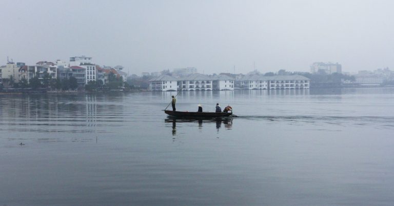
Being the capital city of Viet Nam, Hanoi covers 3,358.6 square kilometres, which is the second-largest city in Viet Nam with over eight million residents within the city area and an estimated population of 20 million within the metropolitan area. In general, the terrain gradually lowers from the north to south and from the west to east, with an average height ranging from 5 to 20 metres above sea level. Hanoi features a warm, humid subtropical climate with plentiful precipitation, making the city highly vulnerable to water-related extreme events such as floods, especially from the overdevelopment of floodplains. Hanoi, a large urban area, has the most rapid urbanization of Viet Nam. The urban area occupies 30% to 32% in 2010 and will reach 55% to 65% in 2030. Within a short time frame, the rapid urbanization process has brought tremendous change, especially in terms of the city’s land-use/land cover characteristics. The inconsistent conversion of land-use/land cover of Hanoi has led to changes in land surface temperature. Therefore the response to climate change and adaptation has been identified as one of the crucial tasks that need a roadmap and plans for implementation.
This study aims to explore climate and land use projection and compare urban water demand, including adaptation plans in Bangkok and Hanoi.
2. Methodology
2.1 Downscaling of climate data
The projected future climate in 2050 in the present study is extracted using the Global Climate Model (GCM) data of HadGEM2-ES at RCP 4.5, produced by the WorldClim database with a 30-second spatial resolution (0.86 square kilometres at the equator) in Bangkok and Hanoi. The climate projection from GCM is downscaled and calibrated (bias-corrected) by using the interpolation technique. Mean temperature, maximum temperature, minimum temperature, and precipitation are projected for 2050 (average for 2041 to 2060) and compared to baseline observation data from 1960 to 1990.
2.2 Land-use modelling
The future socio-economic change in both cities is projected using scenario-based modelling. CLUMondo software was used to model the land-use change in 2050. Three main components are prepared as inputs for CLUMondo; land-use conversion, the logistic regression coefficient of the driving factors, and land-use demand. Three future LULC scenarios were analyzed based on business as usual and the green growth scenarios. A comparison of 2050 land use in Bangkok and Hanoi is conducted using the baseline year in 2013 with 400 metres resolution
2.3 Water resource assessment
Water resource assessment is projected to evaluate the urban water resources by using water flow, urban & agriculture demand site, population and water use rate in both cities. The water evaluation and planning system (WEAP) is an adaptable water resource planning model that is scalable depending on the system’s complexity under investigation and can simulate water allocation policy. The advantage of the WEAP is its reliance on developing scenarios that allow the import of Geographic Infor layers into analysis with basic GIS operations, such as overlays. Each city has three input parameters into WEAP: water supply and demand, water and wastewater infrastructure and climate. Integrated analysis of climate, LUCC, and the water system for assessing urban water demand and supply was conducted to assess the water availability in the two cities.
3. Results and Discussion
3.1 Climate projection for 2050
Annual precipitation, mean temperature, and maximum and minimum temperature are projected and compared with baseline climate data (1960 to 1990).
3.1.1 Bangkok
The projection of mean monthly temperature, maximum temperature, minimum temperature, and annual rainfall for 2050 for Bangkok is illustrated in Figure 1.
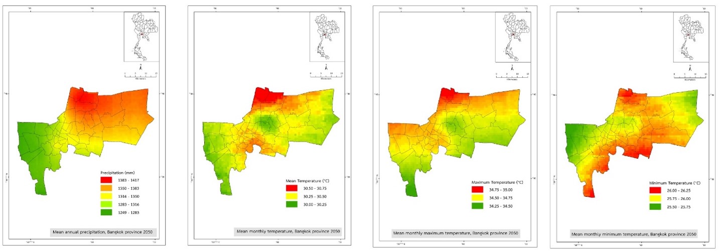
Temperature increases in Bangkok are expected to be within the range of 2.0 °C to 2.4 °C by 2050 in comparison to 1960 to 1990, including mean monthly maximum and minimum temperatures. However, precipitation is projected to decrease by 2050 slightly.
3.1.2 Hanoi
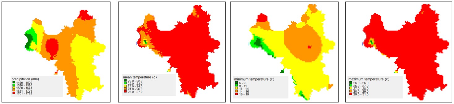
The projection of mean monthly temperature, maximum temperature, minimum temperature, and annual rainfall for 2050 for Hanoi is illustrated in Figure 2.
Climate change scenarios consider the change of climate variables in the middle of the 21st century (2050), such as temperature (maximum temperature (°C), minimum temperature (°C)), and rainfall (monthly rainfall). Downscaled climate data revealed a slight increase in precipitation. Warmer temperatures are expected to increase with drought spells. Greater evaporation, particularly during the summer and fall, could exacerbate drought conditions and increase the risk of wildfires.
A comparative study reveals that the pattern of rainfall change for 2050 in Bangkok and Hanoi is quite similar in terms of increasing temperature that can cause severe drought and heatwave, as indicated by (Costa et al., 2015) and (Guerreiro et al., 2018) . However, the increase in Hanoi’s temperature is slightly higher than in Bangkok, as shown in Table 1 below.
|
Climate parameters |
1960-1990 |
2050 |
||
|
Bangkok |
Hanoi |
Bangkok |
Hanoi |
|
|
Annual precipitation (mm) |
1,445 |
1,689 |
1,337 |
1,645 |
|
Mean monthly temperature (°C) |
28.0 |
23.7 |
30.3 |
26.3 |
|
Mean monthly maximum temperature (°C) |
32.4 |
27.3 |
34.6 |
30.1 |
|
Mean monthly minimum temperature (°C) |
23.6 |
20.1 |
26.0 |
22.5 |
3.2 Land-use projection in 2050
Land-use in 2050 is projected by involving two scenarios: business as usual (BAU) and green growth (GG) scenarios. Physical and socio-economic driving forces, distance to transportation networks and streams, and population density have been used to ascertain the relationship between land use and driving forces through logistic regression. Conversion resistance is one of the specific settings to determine the temporal dynamics of a simulation (Eitelberg, Vliet, & Verburg, 2015).
3.2.1 Bangkok
BAU tends to be driven by higher demands for urban expansion when compared to GG scenarios. The GG scenario encourages the conservation of existing urban green space by minimizing urban expansion in comparison with BAU. A comparison between 2013 land use and 2050 projected land use for the GG scenario is shown in Figure 3 below.
Projected urban land use for BAU and GG in Bangkok in 2050 is increased by 4.8 and 3.1 percent, respectively. The rate of urban expansion for BAU is greater than that of GG scenarios due to urban sprawl and socio-economic development during the last decades.
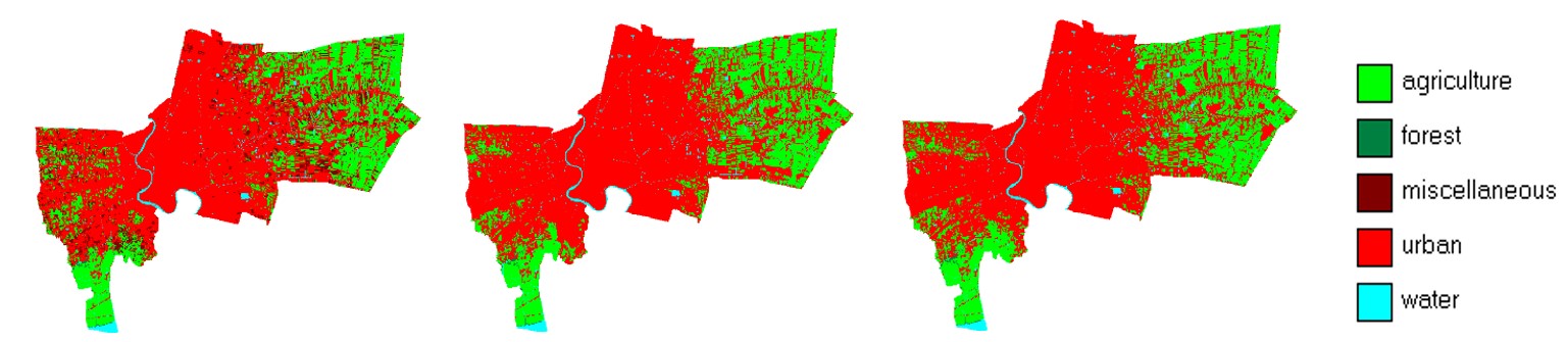
3.2.2 Hanoi
For the BAU scenario, most agricultural and miscellaneous land is converted to urban land with a significant agricultural land proportion. The GG scenario seems to increase the natural assets to provide the resources and environmental services on which the city relies. A comparison between 2015 land use and 2050 projected land use for the GG scenario is shown in Figure 4.
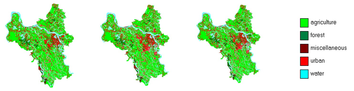
A projection of urban land area for 2050 is increased by 4.2 and 2.4 percent, respectively, compared to 2013. The urban expansion rate for the GG scenario is lower than those of the BAU scenario due to sustainable development goals (SDGs) promoted by the United Nations.
3.3 Water resources assessment
Water resources in cities have been estimated by assessing urban water demand for different activities.
3.3.1 Bangkok
Water demand in Bangkok comes mainly from domestic uses, agriculture activities and small and medium businesses (SMEs). The future water demand tends to increase with the increase in the population due to urban growth in 2050. The top priority for water use is domestic supply, which is having the highest demand, followed by agriculture. Therefore, city planners need to carefully look at effective planning and management under the projected decrease in precipitation and increase in urban expansion. As a result of the 2050 projection, Bangkok will probably face more frequent and more intense floods and heatwaves.
3.3.2 Hanoi
Demand for water in Hanoi for domestic supply remains the highest in 2050 due to continuing increase in urban expansion, followed by industrial parks in the city’s major centres and agriculture. As a result, a careful urban plan and policies need to be developed to meet those demands. Based on the results obtained from the water balance calculations developed for the study area for the 2050 scenario, the watershed will still face many difficulties in terms of distributing and supplying water for domestic, agriculture and industrial use. As a relatively large basin, agriculture is the main activity in the river basin, resulting in high demand for water use. However, water resources in the basin are unevenly distributed over space and time, which causes significant difficulties in distribution works and water use.
Both land use projections indicate a similar pattern of future urban growth in both Bangkok and Hanoi, which can affect the increase in water demand and land requirements. As stated by (Pageler, 2009), the increase in the number of urban dwellers can lead to higher future urban water use and cause a water crisis in case of mismanagement plan and practice.
3.4 Adaptation
3.4.1 Bangkok
There are many challenges to Bangkok in terms of adaptation regarding two crucial factors. The internal factors include population growth, labour migration, overconsumption, economic growth and competition, and capitalization trends. Many external factors influence Bangkok in various aspects, such as technological change, globalization and climate change. These factors significantly impact the environment, e.g., air pollution, solid waste, water pollution, lack of green space, and flooding and coastal erosion. The situation of the rise in the sea level in 2050 is expected to affect Bangkok, becoming far more severe than the current situation. Several measures, such as flood management and drainage infrastructure improvement, and natural buffers and early warning systems, are applied to improve the flood management system.
Furthermore, good coordination among city planners and committees for the upper river basins, such as the Chao Phraya and Tha Chin river basins, is essential to secure a sufficient amount of water for the domestic supply in Bangkok. Although the agricultural land in Bangkok will tend to decrease by 2050 dramatically, drought spells, along with seawater intrusion, might affect Bangkok in terms of water quality and availability. Additionally, urban runoff can be reduced by increasing green spaces, parks and urban wetlands, which can be effective adaptation strategies. This will enable more rainfall to soak into the underlying soil, which will help combat the occurrence of urban flooding.
3.4.2 Hanoi
As a rapidly growing metropolis, the urbanization process has decreased agricultural land and a subsequent increase in residential, industrial, and commercial land. Both projected climate change and land-use/cover change have an impact on water resources. Therefore, adaptation to climate change and land-use/cover change on streamflows within river basins has become necessary in the hydrology and water resource fields. Despite having the essential water management and climate change adaptation plans to lessen the impacts of water security in the future, these plans cannot be expected to counter the effects of a warming climate. The risk of experiencing water shortages limits the effectiveness of local solutions, such as acquiring more water from neighbouring counties or basins since many other localities will attempt to control the same resources. Many infrastructure-based solutions have been proposed for flood protection in Hanoi, i.e. strengthening the dike system in order to protect the right bank of the Red River, relocating houses and construction to areas with reduced flood risk, building upstream water reservoirs to control the pressure of floods, and strengthening flood discharge and construction. Hanoi’s city planners have to find a fair balance between economic growth and the competitiveness of the city on the one hand and the protection of its natural wealth and built environment on the other.
4. Conclusion
Bangkok and Hanoi are among the growing metropolises with the most rapid urbanization in Southeast Asia. This process has led to a decrease in agricultural land and subsequently increasing residential, industrial, and commercial land, resulting in more vulnerability to flooding, both in frequency and intensity. Based on the 2050 projection, climate impacts are expected from a slight decrease in precipitation and an increase in average temperature, which can lead to more frequent heavy rain due to the increase in water vapour in the atmosphere, making extreme water-related weather events stronger than before. The interaction between land-use change and hydrological responses is a complex phenomenon. In this study, urban expansion in both cities is expected to be increased by 2050, affecting the increase of water demand and land requirement in the Chaophraya river basin (Bangkok area) and the Nhue Day river watershed (Hanoi area).
The results reveal that the increase of built-up land and a rapid urbanization rate will significantly affect urban water resources in terms of higher water demand regarding domestic use, agriculture and industrial activities. Urban sprawl in 2050 could be the main cause of land subsidence in Bangkok and Hanoi at present and can worsen some impacts from climate change, i.e. urban flooding, coastal inundation and seawater intrusion. When considering both climate and land-use change in Bangkok and Hanoi in 2050, the increase in temperature is more prominent than precipitation. The combined impact of rising temperatures and urban sprawl may lead to an urban heat stress problem. Thus, urban planners and policymakers should consider their significant impacts and prepare cities for a changing climate. This preparation must be instituted by implementing effective adaptation strategies to integrate climate, land-use, and water resources into the mitigation and adaptation strategies in the short-term and long-term city development plans.