Overcoming barriers to agroforestry adoption: Empowering local farmers through participatory establishment of agroforestry models in Laguna, Philippines
Keywords
Agroforestry · ALCAMs · Local farmers · Participatory approach · Sustainable farming
HIGHLIGHTS
- ALCAMS is a useful and effective tool in assessing the capability of land to support agroforestry
- Two agroforestry models were established, serving as learning sites for local farmers
- Active farmers’ participation throughout the process encouraged the adoption of agroforestry
- Collaboration among stakeholders plays a key role in the success of the agroforestry initiative
1. INTRODUCTION
Sustainable and resilient farming has become critical nowadays as many farming communities around the world face a variety of environmental and socioeconomic issues. Among the serious concerns is the impact of climate change, which is severely affecting the agricultural sector. Studies have shown that climate change reduces farm productivity, which is likely to pose a serious threat to smallholder farmers’ livelihoods, particularly to those farms that are rainfed and have limited options for diversification (Lewis et al., 2018). In addition, soil erosion has been a long-standing constraint in farming, causing degradation to environmental sustainability and reducing soil productivity, thus affecting food security (Ahmad et al., 2020).
In response to these pressing concerns, there is an emerging realisation of the need to shift from conventional farming to climate-resilient and sustainable farming. One of the farming practices that offers harmony between the environment and socioeconomic conditions is agroforestry. It is considered a land use system which integrates perennials with agricultural crops and/or livestock on the same land, creating a diversified and multifunctional farming system. By diversifying income sources, enhancing biodiversity, sequestering carbon and improving soil health, agroforestry has a significant role in ecosystem functions, mitigating climate change impacts and socioeconomic growth (Nguyen et al., 2023; Oelbermann et al., 2024; Santos et al., 2019; Willmott et al., 2023). Globally, agroforestry is recognised as a climate-smart farming initiative that directly contributes to the resilience of communities and the restoration of degraded lands (Dissanayaka et al., 2025; Roy et al., 2025).
Despite the global recognition of the multifaceted benefits of agroforestry, the adoption of this system remains a challenge in the Philippines. The majority of farmers still practice monoculture farming because it is easy to manage, provides immediate economic returns and is deeply rooted in traditions that have been passed down through generations. Other barriers to the adoption of agroforestry could be the lack of awareness (Jha et al., 2021), limited knowledge and understanding (Irwin et al., 2025) and lack of technical assistance related to agroforestry (Baynes et al., 2009).
While convincing every farmer to shift from their current farming practices to agroforestry is challenging, this initiative hypothesises that gradual and community-led approaches, such as establishing agroforestry models, will enhance farmers’ knowledge and skills on sustainable farming practices and thereby encourage their adoption of agroforestry. Exposing farmers to model farms through firsthand observation and hands-on experience may help them recognise the practical benefits of agroforestry for both the environment and their economic welfare. Hence, this initiative aimed to establish an agroforestry model farm through a participatory approach in selected upland farming communities in Laguna, Philippines. It highlights the active involvement of local farmers and other stakeholders in empowering them with sustainable farming practices through agroforestry.
2. METHODOLOGY
2.1. Study sites
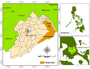
The study was conducted in the province of Laguna, Philippines, specifically in Barangay San Cristobal, San Pablo and Barangay Tala, Rizal. These two barangays are approximately situated 90–100 km southeast of Manila (Figure 1). These are rural areas that are recognised as agricultural production areas due to the land allocated for growing a variety of crops, including vegetables and fruits. Both sites are characterised by having undulating to very steep terrain and fall under climate type III, which has no very pronounced maximum rain period, with the dry season occurring either from December to February or from March to May (PAGASA, 2014).
2.2. Establishing a partnership
Collaboration among stakeholders at each study site was considered crucial for facilitating the project effectively and ensuring its successful implementation. Hence, partnerships were formed prior to the project implementation among the implementers, people’s organisations (POs), and local government units (LGUs). The Mamay Tobal Farmer’s Association of Barangay San Cristobal, San Pablo and Sto. Niño Farmers Association of Barangay Tala, Rizal, Laguna, served as the main partners for this project. Although local farmers were the primary beneficiaries of this initiative, LGUs were also recognised as collaborators. Throughout the entire project cycle, the implementers worked closely with some of the municipal offices responsible for providing agricultural support, managing natural resources and planning various development programmes within their localities. Specifically, these involved the municipal agriculture, municipal environment and natural resources, and the municipal planning and development office.
2.3. Selection of land to serve as agroforestry models
A consultation was conducted with local farmers and representatives of LGUs to identify the best farm for establishing an agroforestry model. This process ensured that the selected farms met the set of criteria and gained community support. For each study site, the selected farms to serve as agroforestry models were chosen based on the following criteria:
Farm Characteristics:
- The farm has a minimum area of 1,500 m2 to provide sufficient space for integrating agroforestry practices.
- The farm must be strategically located to ensure accessibility to many, especially other farmers interested in observing the practices being demonstrated.
Farm Owner Qualifications:
- The farm must be owned by farmers to ensure security and easily facilitate the necessary decision-making in planning and implementing agroforestry activities.
- The farm owner must be an active member of the farmers’ association in the barangay to ensure their active involvement in agricultural practices and be committed to collaboration.
- The farmer must be willing to allocate part of the farm for agroforestry model development.
- The farmer must be willing to dedicate time to both setting up and maintaining the model farm.
- The farmer must be willing to record all farm activities, including harvests, and understand the importance of this data for the farm’s overall development.
- The farmer must be willing to engage in regular monitoring and evaluation to track the progress of the model farm.
- The farmer must be willing to collaborate with project implementers, groups, or institutions to help ensure the smooth implementation of activities.
- The farmer must be willing to participate in agreements established by the farmers’ association concerning the sharing of products produced from the established agroforestry model farm.
- The farmer must be willing to allow other farmers and interested individuals to visit and observe the established agroforestry model as a learning and demonstration area.
- The farmer must be eager to share experiences and insights related to agroforestry practices with fellow farmers and other individuals.
- The farmer must be committed to promoting agroforestry systems within their locality.
2.4. Agroforestry land capability assessment
The Agroforestry Land Capability Assessment and Mapping Scheme (ALCAMS), a tool developed by the Institute of Agroforestry, was used to assess the land’s capability to support agroforestry. At the farm level, three major factors were considered: slope, existing vegetation and soil fertility.
- Slope: The slope was calculated using the conventional approach, where the rise was divided by the run, and the resulting value was multiplied by 100 to get the percentage. Along with the metre tape and metre stick, the A-frame was used as a levelling tool.
- Existing vegetation: This was assessed by determining the current land use, including the identification of existing crops such as vegetables and perennial trees.
- Soil fertility: This was quantified by collecting a composite soil sample from each farm. These samples were sent to the Soils Laboratory of Analytical Services Laboratory, College of Agriculture and Food Science, University of the Philippines Los Baños, where various soil physical and chemical properties were assessed, including soil texture, pH level, organic matter content, phosphorus, potassium and nitrogen.
The results of the assessment of each of these key factors were categorised based on the criteria outlined in Table 1. The resulting combination of the categorised factors determined the specific land capability classes (Tables 2–5), which were crucial in determining the appropriate agroforestry intervention for specific land.
| Slope | Vegetation | Soil Fertility |
|---|---|---|
| S1: 0–18% | L1: Forest | F1: High |
| S2: 18–25% | L2: Brushland/pasture | F2: Medium |
| S3: 25–50% | L3: Open, cultivated | F3: Low |
| S4: >50% | L4: Alienable and Disposable |
| S1L2F1 | S1L3F1 | S1L4F1 |
| S1L2F2 | S1L3F2 | S1L4F2 |
| S1L2F3 | S2L3F2 | S3L4F1 |
| S1L3F3 | S2L4F2 | S3L2F2 |
| S1L4F3 | S2L2F3 | S3L3F2 |
| S2L2F1 | S2L3F3 | S3L4F2 |
| S2L3F1 | S2L4F3 | S3L2F3 |
| S2L4F1 | S3L2F1 | S3L3F3 |
| S2L2F2 | S3L3F1 | S3L4F3 |
| S4L2F1 | S4L2F2 | S4L2F3 |
| S4L3F1 | S4L3F2 | S4L3F3 |
| S4L4F1 | S4L4F2 | S4L4F3 |
| S4L1F1 |
| S4L1F2 |
| S4L1F3 |
The following classification was used to assess the capability of land to support agroforestry:
- Class I (Highly capable for agroforestry): Areas under this category have slopes ranging from 0–18%, are either covered with existing vegetation or utilised as brushland/pasture and may already be planted with perennial crops or cultivated annual crops. These lands are classified as alienable and disposable, with medium to high soil fertility. This indicates a high potential for agroforestry, where incorporation of soil and water conservation may not be necessary. The only limitation is the suitability of crops within the area.
- Class II (Marginally capable for agroforestry): This class includes areas with either of the following conditions: a slope of 0–18% with low soil fertility, or a slope of 18–50% under cultivation, regardless of the crop type. It indicates that the implementation of soil and water conservation measures may be required for agroforestry to be sustainable.
- Class III (Conditionally capable for agroforestry): This class refers to areas with more than 50% slope, either used for cultivation with low soil fertility or utilised as brushland/pasture with low soil fertility. This indicates that proper soil and water conservation practices are required to establish agroforestry.
- Class IV (Not for agroforestry use): Any land that has a slope greater than 50% and either currently used as forest land or any public land that is being used for specific purposes such as forest reserves or parks. This suggests that the land is more suitable for uses other than agroforestry.
2.5. Establishment of agroforestry models
The farm-level biophysical assessment conducted at each study site served as the basis for selecting the appropriate agroforestry system to be established. The choice of agricultural crops and perennial tree species was made upon consultation with stakeholders, including local farmers and local agricultural technicians. This participatory decision was crucial to ensure that all aspects of the established agroforestry model were tailored to the specific local needs and conditions. The establishment phase, which includes the layout and planting of selected crops and trees, was carried out with the active involvement of the local farmers, particularly those who were active members of the PO. These farmers were not only involved in the planting stage but also took part in monitoring and managing the established agroforestry model. The agroforestry model farms were established in August 2024.
2.6. Monitoring of agroforestry models
Monitoring the agroforestry model is essential to assess the system’s progress and performance. For this project, monitoring was conducted over a period of seven (7) months, from September 2024 to March 2025. The growth performance of fruit-bearing trees was determined by measuring the actual height and diameter of each seedling using a meter stick and digital calliper, respectively. These measurements were taken every two (2) months. Additionally, the costs and revenues of the short-term crops were recorded on a per-hectare basis, including expenses for manpower, seeds and other maintenance operations.
2.7. Data analysis
Both descriptive and inferential analyses were employed to highlight the key features observed in the establishment of agroforestry models. The Wilcoxon rank test was used to compare the growth performance among the different plant species.
3. RESULTS AND DISCUSSION
3.1. Farm characteristics
Each model farm exhibited distinct biophysical characteristics which influence its suitability for agroforestry development (Table 6). While the two model farms are nearly similar in their land area, their elevation and slope differ. A gentle slope was observed in Barangay San Cristobal, implying a more accessible and less susceptible area to erosion. Conversely, the higher elevation and steeper slope in Barangay Tala indicate a challenging farm management system, particularly in terms of soil conservation. In terms of soil texture and fertility, both had sandy loam soil and low fertility, which explains why they were classified as Class II – marginally capable for agroforestry. Despite this, several agroforestry systems can be employed on both sites. Considering the landscape of Barangay San Cristobal and the presence of various fruit-bearing tree species that can thrive therein, a fruit-tree-based agroforestry was chosen as a suitable agroforestry system in the area. Meanwhile, an alley cropping system was employed as an agroforestry system in Barangay Tala due to its potential for production and soil and water conservation.
| Farm attributes | Barangay San Cristobal, San Pablo | Barangay Tala, Rizal |
|---|---|---|
| Farm size | 2,409 m2 | 2,441 m2 |
| Elevation | 313 masl | 617 masl |
| Slope | 8.6% | 28.5% |
| Soil texture | Sandy loam | Sandy loam |
| Soil fertility | Low | Low |
| Land capability class based on ALCAMS | Marginally capable for agroforestry | Marginally capable for agroforestry |
3.2. Agroforestry system established at each study site
The fruit tree-based agroforestry system established in Barangay San Cristobal, San Pablo, serves as a model for sustainable farming (Figure 2a). The integration of high-value fruit trees, such as avocado (Perseaamericana), lanzones (Lansiumdomesticum), and durian (Duriozibethinus), along with short-term agricultural crops, demonstrates the multifunctional features of agroforestry. The use of these high-value fruit trees was vital, as they have been identified as well-suited to the area and address long-term economic and environmental sustainability by diversifying farm income and supporting ecosystem services.
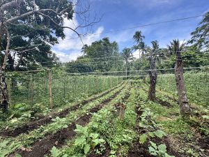
In this agroforestry model, the integration of short-term crops such as eggplant (Solanum melongena), string beans (Phaseolus vulgaris), squash (Cucurbita maxima), and long green chilli pepper (Capsicum sp.) through intercropping provides immediate sources of food and economic needs while waiting for the fruit trees to mature. Practising intercropping techniques in agroforestry helps not only to optimise the land’s economic potential but also to boost biodiversity (Moreira et al., 2024) and reduce the incidence of pests and other diseases (Toker et al., 2024). In countries like Vietnam and Ethiopia, similar agroforestry systems demonstrated multiple benefits, including higher economic return in the long run and support ecosystem services such as soil erosion reduction, carbon sequestration, and maintain soil moisture and fertility (Bogale et al., 2023; Do et al., 2020).
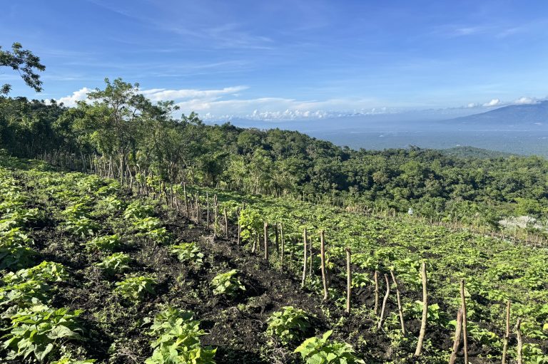
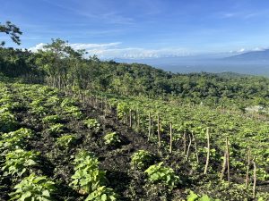
Meanwhile, the alley cropping system established in Barangay Tala, Rizal, is characterised as an innovative practice addressing concerns on soil and water conservation, biodiversity enhancement and economic management for farmers in sloping and/or marginal lands (Figure 2b). In particular, alley cropping is a form of agroforestry system in which rows of trees and/or shrubs are planted along the contour line while short-term crops are cultivated along the alleys (Cárceles Rodríguez et al., 2022). By using kakawate (Gliricidia sepium) as hedgerows, it acts as a soil conservation measure by significantly reducing soil and nutrient loss through their above and below biomass (Xiao et al., 2024). Similarly, the nitrogen-fixing properties of kakawate improve organic matter and other soil properties (Srinivasa Rao et al., 2011). In addition to the soil quality, the alley cropping system established in Barangay Tala optimises land use by combining perennial hedgerows with short-term crops such as eggplant (Solanum melongena), sweet potato (Ipomoea batatas), cabbage (Brassica oleracea var. capitata), mustard greens (Brassica juncea) and radish (Raphanus sativus). These short-term crops offer a valuable contribution to the overall food production, making agroforestry not only economically viable but also addressing food security.
Additionally, in high-elevation areas like Barangay Tala, the area is exposed to strong winds, particularly during the northeast monsoon. This exposure can result in soil erosion and crop damage, which is a common concern among farmers in mountainous areas. To mitigate this concern, the agroforestry system model in Barangay Tala integrates perennials along its boundary to serve as windbreaks. Perennial trees such as lipote (Syzygium polycephaloides), duhat (Syzygium cumini), pili (Canarium ovatum) and even mango (Mangifera indica) were among the chosen species for windbreak due to their stability and potential in enhancing ecosystem services such as the provision of shade, maintenance of soil structure and moisture, carbon sequestration, and biodiversity conservation (Lasco et al., 2015). Likewise, these trees can provide extra income for the farmers once they mature and produce fruits and/or nuts.
3.3. Monitoring agroforestry model farms
3.3.1. Survival rate and growth performance of fruit-bearing trees
Fruit-bearing trees were carefully integrated into both model farms to enhance their environmental resilience and farm productivity. In terms of survival rate, all planted seedlings exhibited a 100% survival rate in the fruit tree-based agroforestry model, which reflects suitable site conditions and effective farm management. Meanwhile, in the alley cropping agroforestry model, a 100% survival rate was observed for most of the seedlings except for duhat, which showed a slightly lower survival rate of 80%. The reduced survival of duhat was attributed to human activity, particularly the unintended cutting of seedling stems during farm maintenance work. To ensure the integrity of the agroforestry model, replanting was promptly conducted to replace the damaged seedlings.
In general, the performance of planted fruit-bearing trees was favourable, although a few exhibited irregular growth, specifically at the model farm in Barangay Tala. It was observed that there was a reduction in the height of the duhat in the 3rd measurement and for the mango in the 3rd and 4th measurements (Table 8). These reductions were likely due to the accidental trimming of the top portions of some seedlings, which may have affected their height measurements. Meanwhile, the growth performance (height and diameter) of durian and lanzones in the model farm located at Barangay San Cristobal showed significant change, while avocado exhibited no significant change. At the model farm in Barangay Tala, the mango tree species demonstrated a statistically significant increase in diameter. Other species showed growth in both height and diameter, but these changes were not statistically significant. Nevertheless, most of the planted trees across model farms showed promising performance, as evidenced by increases in both height and diameter over the seven-month monitoring period (Tables 7 and 8). This suggests that the current management applied and the farm conditions are generally effective in promoting the growth and development of the fruit-bearing trees. In agroforestry practices, improved management techniques such as proper fertilisation can be done to further maximise the growth potential of all fruit-bearing trees (Do et al., 2020).
| Fruit-bearing trees | Mean height (cm) | Mean diameter (mm) | ||||||
|---|---|---|---|---|---|---|---|---|
| 1st | 2nd | 3rd | 4th | 1st | 2nd | 3rd | 4th | |
| Durian (Durio zibethinus) | 67.94a | 70.38 | 77.43 | 75.22b | 7.58a | 8.11 | 12.22 | 13.3b |
| Lanzones (Lansium domesticum) | 94.50a | 95.55 | 99.00 | 101.00b | 7.47a | 7.77 | 9.67 | 10.3b |
| Avocado (Persea americana) | 53.50 | 62.75 | 64.25 | 87.75 | 10.20 | 11.61 | 16.08 | 20.12 |
| Values with different superscript letters (a, b) within the same row indicate statistically significant differences at p < 0.05. | ||||||||
| Fruit-bearing trees | Mean height (cm) | Mean diameter (mm) | ||||||
|---|---|---|---|---|---|---|---|---|
| 1st | 2nd | 3rd | 4th | 1st | 2nd | 3rd | 4th | |
| Duhat (Syzygium cumini) | 34.30 | 51.60 | 51.00 | 67.00 | 7.64 | 8.17 | 10.36 | 14.57 |
| Lipote (Syzygium polycephaloides) | 82.30 | 88.40 | 88.50 | 90.80 | 9.66 | 11.79 | 13.83 | 16.38 |
| Pili (Canarium ovatum) | 51.81 | 65.88 | 86.50 | 99.63 | 9.83 | 12.17 | 15.34 | 18.39 |
| Mango (Mangifera indica) | 96.86 | 101.43 | 99.43 | 92.00 | 13.91a | 15.20 | 17.83 | 19.63b |
| Values with different superscript letters (a, b) within the same row indicate statistically significant differences at p < 0.05. | ||||||||
3.3.2. Financial analysis of the agroforestry models
An initial cost and revenue analysis of two (2) established model farms was conducted to assess their potential in generating income for farmers. The analysis included both establishment and maintenance costs, which comprised the overall farm cost as well as the revenue generated from the sales of harvested agricultural crops (Table 9). For the fruit tree-based agroforestry model, the introduced high-value fruit trees are still at their early stage of growth and have yet to provide additional income. Hence, the revenue was primarily derived from agricultural crops. Overall, it generated a net income of $117.80 on its first production cycle. Results suggest that fruit tree-based agroforestry generates positive economic returns, even in the early stages of establishment, when intercropped with agricultural crops. While other studies showed that fruit tree-based agroforestry had higher investment costs when compared to a monoculture system, it offered higher economic benefits once the fruit trees began to bear fruit 3–4 years after their establishment (Do et al., 2020). Over time, this kind of agroforestry system is more economically viable than monocropping systems as it is labour-efficient and has a lower-risk investment with diversified income sources (Kassa, 2015).
| FRUIT TREE-BASED | ALLEY CROPPING | |
|---|---|---|
| COST | ||
| A. Establishment | ||
| Variable Cost | ||
| Seeds (beans), kg | 72.82 | |
| Seedlings (eggplant), per tray | 37.87 | |
| Twines, roll | 37.87 | |
| Chicken manure | 21.85 | 86.25 |
| Seeds (cabbage), per tray | 280.30 | |
| Seedlings (eggplant), per tray | 93.43 | |
| Total variable cost | 170.41 | 459.98 |
| Fixed Cost | ||
| Avocado, seedlings | 29.13 | |
| Lanzones, seedlings | 145.65 | |
| Durian, seedlings | 117.98 | |
| Kakauate stakes | 127.93 | |
| Pili, seedlings | 34.50 | |
| Lipote, seedlings | 16.17 | |
| Mango, seedlings | 75.47 | |
| Duhat, seedlings | 53.90 | |
| Total fixed cost | 292.76 | 307.97 |
Total Establishment cost |
463.18 |
767.95 |
| B. Maintenance/Management | ||
| Insecticide, karate | 49.52 | |
| Herbicides | 93.43 | |
| Fertiliser, kg | 31.86 | 118.59 |
| Labour, manday | 400.54 | 503.10 |
Total Maintenance cost |
481.93 |
715.12 |
Grand total cost |
945.10 |
1,483.07 |
| REVENUE | ||
| C. Harvest | ||
| Eggplant, kg | 275.28 | 618.10 |
| Beans, kg | 787.62 | |
| Cabbage, kg | 229.99 | |
| Sweet potato, kg | 668.41 | |
Total revenue |
1,062.90 |
1,516.49 |
| NET INCOME | 117.80 |
33.42 |
Meanwhile, the alley cropping established in Barangay Tala generated lower returns of $33.42 compared to fruit tree-based (Table 9). This can be attributed to the adverse impacts of heavy rainfall brought about by the southwest monsoon and a typhoon that hit Laguna province in 2024, resulting in significant damage to the agricultural crops. Nevertheless, previous studies have shown the promising potential of alley cropping, particularly in improving farmers’ economic condition, demonstrating higher net present value (NPV) than monocultures (Xu et al., 2019). This aligns with the findings of Cary and Frey (2020), showing that alley cropping offers higher NPV compared to monocropping even under climate risk.
3.4. Lessons to carry forward
The establishment of agroforestry models using a participatory approach has generated essential lessons or insights that can serve as a guide for future initiatives. These are the following:
- Community engagement builds ownership – Active involvement of stakeholders throughout the project phases (planning, decision-making, implementation) can shape a strong sense of ownership. This tends to potentially increase their commitment to devote time and effort to ensure success.
- Capacity building empowers farmers – Initiatives such as training sessions and exposure trips to successful farms practising sustainable techniques enable farmers to develop an in-depth understanding of agroforestry concepts and principles. Hands-on experience also boosts farmers’ confidence in managing and adopting agroforestry effectively on their own farms.
- Harmonising local and scientific knowledge is crucial – Effective agroforestry initiatives are founded on the combination of local knowledge and scientific principles. Local farmers have a deep understanding of the environment in which they live — plant species that thrive in the area, local climate, the season for planting, and even soil conditions are essential, which is crucial for planning and designing an appropriate agroforestry system. Through the integration of scientific and local knowledge, the agroforestry model can be more adaptive to the current site conditions and more readily accepted by the community.
- Good coordination is facilitated by clearly defined roles and responsibilities – Defining stakeholders’ roles and responsibilities from the initiation phase promotes accountability, ensures active participation, and helps avoid confusion and conflicts. Consistent communication and open discussions among stakeholders are also effective strategies for keeping everyone informed and staying on track.
- Working together for a common drive to success – When individuals come together to achieve a common goal, voluntary cooperation becomes a powerful catalyst for any initiative’s success. The willingness to collaborate and contribute without expecting anything in return builds social capital and strengthens the ability to overcome challenges. In the Philippines, this spirit is locally known as “bayanihan”, a deeply ingrained cultural value that highlights communal unity and cooperation.
4. CONCLUSION
This effort demonstrates how the promotion and adoption of agroforestry can be boosted by successfully establishing model farms through a participatory approach. Local farmers often embrace new farming practices when they see the practical benefits and gain firsthand experience. The established fruit tree-based system in Barangay San Cristobal and the alley cropping system in Barangay Tala serve as demonstration sites, offering valuable opportunities for learning and promoting sustainable farming among local communities.
A key strength of this initiative was the use of the Agroforestry Land Capability Assessment and Mapping Scheme (ALCAMS) as a practical and unique tool for land assessment. ALCAMS facilitated the determination of the land’s capability to support agroforestry and the identification of appropriate agroforestry systems tailored to site-specific conditions. Meanwhile, the success of the establishment can also be attributed to stakeholders’ active involvement, particularly the local farmers. Their hands-on engagement in all phases of agroforestry management developed a sense of ownership and empowerment. Additionally, the strong support from the LGU played a key role in the success of the initiative.
While the initial assessment of the agroforestry models showed positive results, such as favourable growth performance of fruit-bearing trees and positive economic returns, it is important to note that these outcomes were based on a seven-month monitoring period and were limited to two pilot sites. Moreover, findings have no direct comparisons with the conventional monocropping system, and no long-term ecological assessments were conducted. As such, further efforts should prioritise the long-term ecological and economic monitoring to better understand the sustainability and scalability of the agroforestry system. Additionally, it is recommended that agroforestry be incorporated in the development plans and programmes to support its widespread adoption.
5. ACKNOWLEDGEMENT
The authors would like to express their gratitude to the Asia-Pacific Network for Global Change Research (APN) for the financial support given to successfully implement this initiative under the Grant No. CBA2022-07MY-Ramirez. The authors are, likewise, grateful to the University of the Philippines Los Baños-Institute of Agroforestry (UPLB-IAF) for the technical and logistical support given to smoothly execute all the necessary activities. Sincere thanks are also given to the Mamay Tobal Farmers’ Association of Barangay San Cristobal, San Pablo, and Sto. Niño Agroforestry Farmer Association of Barangay Tala, Rizal, for their dedication and strong commitment to this initiative that contributed to its success. The LGUs of San Pablo and Rizal, Laguna, particularly the offices of agriculture, environment and natural resources, and planning and development, are also acknowledged for their unwavering support.